* The Ka Huru Manu project is now complete. You may also wish to check Canterbury Maps online. Please note that both of these mapping systems are living documents. As they are constantly being revised, information in them can only be considered to be a guide.
5.8 Ngā Tūtohu Whenua
Wāhi Tuarima | Part 5
Ngā Take ā-rohe Me Ngā Kaupapa | Regional Issues and Policy
5.8 Ngā Tūtohu Whenua | Cultural Landscapes [CL]
This section addresses issues associated with Ngāi Tahu cultural heritage: sites, places, resources, traditions, knowledge, and landscapes of importance to Ngāi Tahu. This includes wāhi tapu, wāhi taonga, mahinga kai and other sites of significance, and the traditional and contemporary landscapes within which they occur. For Ngāi Tahu cultural heritage isn’t something that happened in the past; but rather a reflection of an ongoing and enduring relationship with the land.
Ngā tūtohu whenua, or cultural landscapes, is a concept used in this IMP to recognise areas and places of particular importance. As a planning tool, cultural landscapes are a culturally meaningful and effective framework for the identification, protection and management of sites and places of significance, the multiple values associated with those sites and places, and the relationship of tāngata whenua to them.
The RMA 1991 instructs local authorities, in relation to managing the use, development and protection of natural and physical resources, to recognise and provide for the following matters of national importance:
- The protection of historic heritage from inappropriate subdivision, use and development (s.6 (f)).
- The protection of outstanding natural features and landscapes from inappropriate subdivision, use and development (s.6 (b)). The courts have used this as a mechanism to consider cultural landscapes of historical importance.
- The relationship of Māori and their culture and traditions with their ancestral lands, water, sites, wāhi tapu and other taonga (s.6 (e)).
Ngā Paetae | Objectives
(1) Cultural landscapes are recognised and provided for as a planning tool to protect wāhi tapu and wāhi taonga, the multiple values associated with these sites and places (traditional and contemporary), and the relationship of tāngata whenua to them.
(2) The Ngāi Tahu cultural heritage mapping project is completed and used to effectively protect and manage wāhi tapu and wāhi taonga in a manner consistent with tikanga Ngāi Tahu.
(3) Wāhi tapu and wāhi taonga are protected from inappropriate use, subdivision and development.
(4) Ngāi Tahu whānui have access to sites of cultural significance in the takiwā.
(5) Good working relationships are maintained with those agencies involved in the protection of Ngāi Tahu cultural and historic heritage, including the New Zealand Historic Places Trust Pouhere Taonga (NZHPT).
Ngā Take | Issues of Significance
- CL1: Cultural landscapes
- CL2: Cultural mapping
- CL3: Wāhi tapu me wāhi taonga
- CL4: Silent files
- CL5: Access
- CL6: Ingoa wāhi
- CL7: Ngāi Tahu tikanga tūturu
- CL8: Maunga
CL1: Recognising Cultural Landscapes
Issue CL1: Ngā Tūtohu Whenua –
(a) There is a need for culturally appropriate tools to identify and express the relationship of tāngata whenua with particular places, and the values that define that relationship;
(b) Land use and development can have both positive and adverse effects on cultural landscapes;
(c) An RMA focus on outstanding landscapes and outstanding natural features can mean that cultural landscapes are not recognised in planning and policy;
(d) Enhancement and restoration of cultural landscapes is important to Ngāi Tahu culture, identity and well being.
Ngā Kaupapa / Policy
CL1.1 To require that local and central government recognise and provide for the ability of tāngata whenua to identify particular landscapes as significant cultural landscapes, reflecting:
(a) Concentration, distribution and nature of wāhi tapu and wāhi taonga;
(b) Setting within which sites occur and significance of that setting;
(c) Significance with regard to association and relationship to place;
(d) Degree of risk/threat.
CL1.2 To require that local and central government give effect to cultural landscapes in policy, planning and decision making processes as a tool to:
(a) Enable holistic assessment of effects on cultural values;
(b) Recognise the relationship of Ngāi Tahu to particular areas and sites;
(c) Provide a wider context for cultural heritage management and the protection of individual sites.
CL1.3 To work with local authorities to increase awareness and knowledge of the use of cultural landscapes as a tāngata whenua planning tool.
CL1.4 To require that oral tradition and history is considered equally alongside documented evidence when determining the cultural landscape values associated with a particular area or site.
CL1.5 To require that NTCSA 1998 provisions are recognised and provided for as cultural landscape indicators, including Statutory Acknowledgments, Nohoanga, Tōpuni and Dual Place Names provisions.
CL1.6 To require that known Māori archaeological sites and silent files are recognised and provided for as cultural landscape indicators.
Protecting and restoring cultural landscapes
CL1.7 To use the following methods to protect and restore cultural landscapes of particular importance:
(a) Purchasing particular areas (tribal or Papatipu Rūnanga ownership);
(b) Designation as Māori reserve;
(c) Registration with Historic Places Trust as wāhi tapu or wāhi tapu area;
(d) Co-management arrangements or transfer of ownership; (e) Development of restoration plans to restore the mauri of particular places;
(f) Covenants (e.g. heritage, open space, protective, etc);
(g)Heritage orders;
(h) Zoning in district plans to protect places from development;
(i) Designation as Mahinga Kai Cultural Park;
(j) Designation as Historic Reserve or local purpose reserve, under the Reserves Act 1977.
CL1.8 To identify opportunities to enhance cultural landscapes, including but not limited to:
(a) Restoration/enhancement of indigenous biodiversity;
(b) Enhancing views and connections to landscape features;
(c) Appropriate and mandated historical interpretation;
(d) Setting aside appropriate areas of open space within developments;
(e) Use of traditional materials, design elements and artwork.
CL1.9 To enhance Ngāi Tahu cultural landscape values in the takiwā by:
(a) Protection and restoration of places of cultural value to Ngāi Tahu, including those associated with mahinga kai;
(b) Restoration and enhancement of indigenous biodiversity on the landscape, rural and urban;
(c) Providing for cultural traditions (both traditional and contemporary) associated with particular places, including mahinga kai and recreational use (e.g. waka ama);
(d) Incorporating Ngāi Tahu heritage values into landscape and urban design, through the use traditional place names, interpretation, artwork and public structures.
He Kupu Whakamāhukihuki / Explanation
The whole of the Canterbury region has cultural landscape value: Ngāi Tahu travelled through, engaged with and named the land, and tāngata whenua history is part of the landscape. However, within this landscape of Ngāi Tahu land use and occupancy particular areas are identified as cultural landscapes.
A cultural landscape is a geographical area with particular (and often related) traditional, historical, spiritual and ecological value to Ngāi Tahu. An area may be identified as a cultural landscape due to the concentration of values in a particular location, the particular importance of the area to Ngāi Tahu cultural, history or identity, or the need to manage an area as a particular landscape unit. Cultural landscapes are integral to Ngāi Tahu culture, identity and history, and are testament to relationship of tāngata whenua with the land over time. They are intergenerational: providing future generations (our tamariki and mokopuna) the opportunity to experience and engage with the landscape as their tūpuna once did.
Cultural landscapes provide a culturally appropriate and useful framework for assessing and protecting the physical features of a site or area (e.g. sites of significance) and the relationship of tāngata whenua and their culture and tradi-tions to the site or area (RMA s.6(e)). The values associated with particular cultural landscapes are indicators of what tāngata whenua value most about the land.
Planning for cultural landscapes is useful when making decisions about resources and appropriate use of an identified area, providing an assessment of potential effects on a site, place or resource and the relationship of that site, place or resource within a larger landscape of values and meaning. A cultural landscape approach shifts the focus from individual sites (e.g. New Zealand Archaeological Association or NZAA site) to the wider setting or context of a site - the relationship and linkages of the site to the area and other landscape features.
"Archaeological sites exist not only as entities in their own right, but as part of a much larger Ngāi Tahu identity. Some areas must be considered in light of the contribu-tion they make to the greater picture, not merely on the basis of their individual and isolated attributes. Ngāi Tahu concern with archaeological sites extends beyond that of ancestral connection alone. They are also valuable sources of information on the activities of their Tupuna which those in the present world know little about." (2)
He Kupu Whakamāhukihuki / Explanation
The focus on Policies CL1 to CL8 is to promote the recognition of cultural landscapes as a tāngata whenua land use planning and heritage management tool in regional and district planning and decision making processes, including landscape assessment and assessments of effects on the environment associated with resource consent applications, outline development plans, structure plans and area master plans. As a planning tool, cultural landscapes enable recognition of the particular cultural associations to an area and the way that activities may impact on those associations, including tāngata whenua aspiration and outcomes for that landscape.
Part 6 of this IMP identifies specific cultural landscapes in the various catchments of the takiwā, and local issues associated with those landscapes. An important kaupapa is that while land use and development has the potential to adversely affect cultural landscape values, these activities may also provide opportunities also enhance cultural landscapes. For example, the rebuild of Christchurch provides a significant opportunity to restore features of the traditional Ngāi Tahu cultural landscape and reflect the contemporary relationship of Ngāi Tahu to the city (see Section 6.5 Ihutai).
Te Aranga: Māori Cultural Landscape Strategy
- As Māori we have a unique sense of our cultural landscape. It includes past, present and future. It includes both physical and spiritual dimensions.
- It is how we express ourselves in our environment, it connects whānau and whenua through whakapapa, it includes both urban and rural, it is not just where we live it is who we are!
- The Māori Cultural Landscape Strategy is a strategy which enables us to work collaboratively to enhance our cultural landscapes so we can better see our faces in our places!
Source: Te Aranga: Māori Cultural Landscape Strategy – www.tearanga.maori.nz
Cross reference:
» Issue CL2: Ngāi Tahu Cultural Mapping
» Issue CL3: Protection of wāhi tapu me wāhi taonga
» Issue CL5: Access to wāhi tapu and wāhi taonga
» Issue CL7: Ngāi Tahu tikanga tūturu
» Appendix 2 – NZAA sites from the Hurunui to the Hakatere
Information resource:
» NZHPT (2012). Heritage Guidance for Iwi Management Plans: A guide for Māori working in resource management and planning. [Appendix 1 of this document provides an excellent summary of legislative frameworks for Māori heritage, including further information on the methods identified in Policy CL1.7 above).
CL2: Cultural Mapping
Issue CL2: There is a need for a comprehensive and accurate source of information on sites of significance, and a tool to protect and manage these sites according to tikanga Ngāi Tahu.
Ngā Kaupapa / Policy
CL2.1 To recognise and provide for the Ngāi Tahu Cultural Heritage Mapping Project as an authoritative source of information on wāhi tapu, wāhi taonga, mahinga kai and other cultural landscape features in the takiwā covered by this IMP.
CL2.2 To work with Te Rūnanga o Ngāi Tahu on the Ngāi Tahu Cultural Heritage Mapping Project to:
(a) Ensure that Papatipu Rūnanga maintain control and ownership of information used in the project;
(b) Develop access policies regarding who can access and use different types of information;
(c) Investigate the use of Heritage Alert Layers and Heritage Risk Models as mechanisms to integrate information from the Ngāi Tahu Cultural Mapping Project into central and local government planning processes.
He Kupu Whakamāhukihuki / Explanation
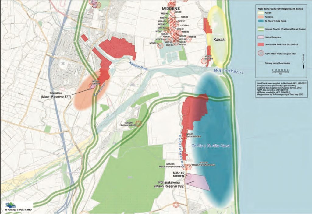
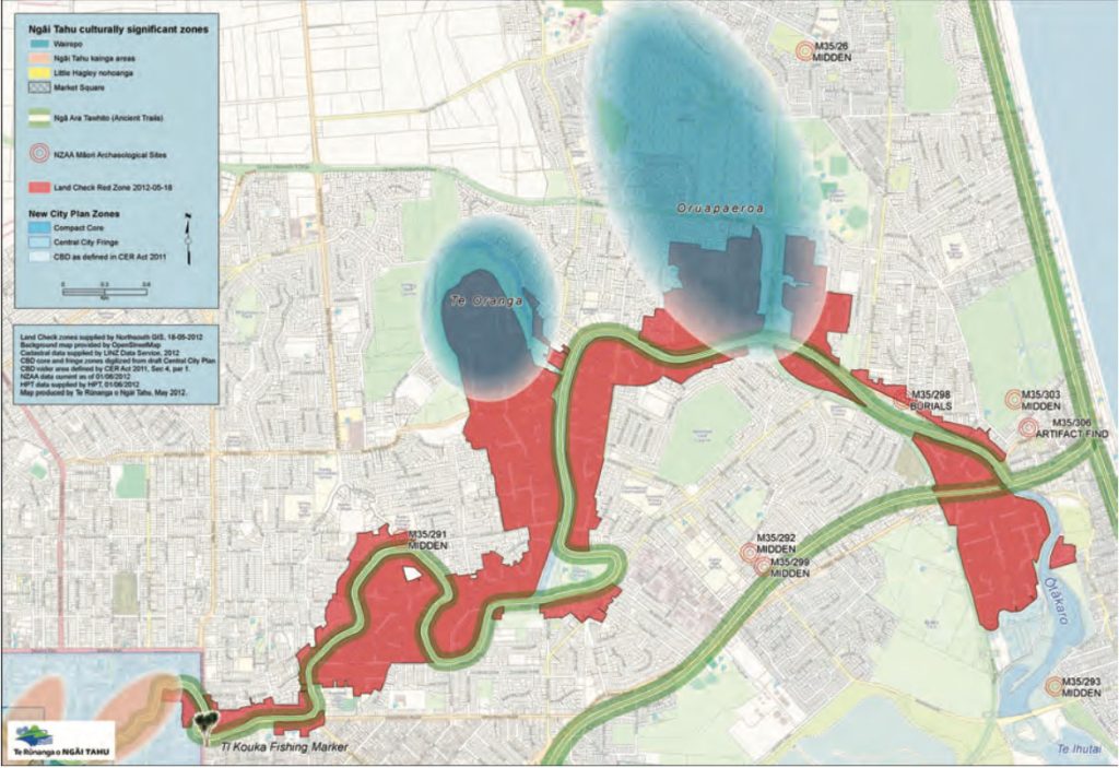
Since 2006 Toitū Te Whenua (Environmental Management Unit for Te Rūnanga o Ngāi Tahu) has been working with Papatipu Rūnanga to map sites of cultural significance and develop an electronic database on the Toitū Te Whenua Geographical Information System (GIS). Examples of sites and values include archaeological sites, ingoa wāhi (traditional place names), ara tawhito (ancient trails), wāhi tapu and mahinga kai.
Once complete*, the Ngāi Tahu Cultural Heritage Mapping Project will assist Papatipu Rūnanga to manage and protect cultural heritage values, providing a reliable and accurate basis of information upon which to inform planning maps and provide guidance to local authorities (see examples below of maps produced by Te Rūnanga o Ngāi Tahu for the Christchurch and Kaiapoi Red Zones) . The outcomes of the project may also be used by Ngāi Tahu to develop Heritage Risk Models or Heritage Alert Layers on planning maps, similar to the use of “hot zones” at Te Mata Hāpuku (see Section 6.10, Issue W6).
Maps 4 and 5: Ngāi Tahu culturally significant zones in the Kaiapoi and Christchurch Red Zones (Interim land management options map prepared by Te Rūnanga o Ngāi Tahu). These maps are an example of how cultural mapping work can be used to inform planning maps and decision making.
CL3: Wāhi tapu me wāhi taonga
Issue CL3: Identification, protection and management of wāhi tapu and wāhi taonga.
Ngā Kaupapa / Policy
CL3.1 All taonga within the takiwā of Ngāi Tahu, accidental discovery or otherwise, belong to the Papatipu Rūnanga/ Te Rūnanga o Ngāi Tahu.
Information on wāhi tapu and wāhi taonga
CL3.2 The Ngāi Tahu Cultural Heritage Mapping Project is an authoritative source of information on wāhi tapu, wāhi taonga, mahinga kai and other cultural landscape features in the takiwā covered by this IMP (as per Policy CL2.1 and CL2.2).
CL3.3 To ensure that local and central government recognises:
(a) Existing schedules and maps of cultural sites are not comprehensive nor exhaustive;
(b) Many sites and information about sites are held by whānau;
(c) Protecting wāhi tapu and wāhi taonga requires effective working relationships with Papatipu Rūnanga.
CL3.4 To require that oral tradition and history is considered equally alongside documented evidence when determining the nature, extent or significance of wāhi tapu or wāhi taonga values associated with a particular area or site.
CL3.5 To require that existing registered NZAA sites are recognised and provided for as indicator sites only, reflecting a larger network of Ngāi Tahu cultural heritage values. Any development of area adjacent to a NZAA site must be considered and monitored for potential effects on unknown additional sites (see Appendix 2).
Protecting wāhi tapu and wāhi taonga
CL3.6 Ngāi Tahu have the right to identify any site as a wāhi tapu or wāhi taonga, and have the discretion as to how these sites are protected, including the right to identify sites that must be protected from development. It is anticipated that the NZHPT will support Papatipu Rūnanga in this process, as part of the Trust’s kaupapa to support the management and kaitiakitanga by whānau, hapū and iwi of their heritage places.
CL3.7 To require appropriate policies and rules in territorial and regional plans to protect sites of cultural significance from inappropriate land use and development, including but not limited to:
(a) Explicit recognition of the relationship of tāngata whenua to wāhi tapu and wāhi taonga;
(b) Processes for engagement with Papatipu Rūnanga with regard to wāhi tapu and wāhi taonga;
(c) Recognition of cultural landscapes as a planning tool to identify and assess sites (see Issue CL1);
(d) Recognition of silent files (see Issue CL4);
(e) Recognition that wāhi tapu and wāhi taonga values may extend beyond the physical boundaries of individual sites;
(f) Setting aside land from development.
CL3.8 To require, where a proposal is assessed by tāngata whenua as having the potential to affect wāhi tapu or wāhi taonga, one or more of the following:
(a) Low risk to sites:
(i) Accidental discovery protocol (ADP) - See Appendix 3
(b) High risk to sites:
(i) Cultural Impact Assessment (CIA);
(ii) Site visit;
(iii) Archaeological assessment, by a person nominated by the Papatipu Rūnanga;
(iv) Cultural monitoring to oversee excavation activity, record sites or information that may be revealed, and direct tikanga for handling cultural materials;
(v) Inductions for contractors undertaking earthworks;
(vi) Accidental discovery protocol agreements (ADP); and/or
(vii) Archaeological Authority from the New Zealand Historic Places Trust.
CL3.9 To support a range of methods to protect sites identified as wāhi tapu and wāhi taonga, including but not limited to:
(a) Registration with Historic Places Trust as wāhi tapu or wāhi tapu area;
(b) Covenants (e.g. heritage, open space);
(c) Heritage orders;
(d) Designation as Historic Reserve or local purpose reserve, under the Reserves Act 1977;
(e) Tribally developed ‘hot zones’, Heritage Risk Models or Heritage Alert Layers to protect wāhi tapu, wāhi taonga and archaeological sites; and
(f) Methods to protect and restore cultural landscapes, as per Policy CL1.7.
Archaeological assessments
CL3.10 When an archaeological assessment is required or archaeology is undertaken at a site or area where wāhi tapu and wāhi taonga values exist or may exist:
(a) The consultant archaeologist should be determined by the Papatipu Rūnanga;
(b) The Papatipu Rūnanga will advise whether a cultural monitor is required;
(c) Cultural monitors are responsible to the Papatipu Rūnanga, and not the archaeologist; and
(d) The Papatipu Rūnanga may have specific tikanga requirements with regard to the recording, handling, storage, care and final placement of taonga.
Archaeological authorities
CL3.11 Any application for an Archaeological Authority to damage, destroy or modify a wāhi tapu or wāhi taonga site must involve engagement with Papatipu Rūnanga.
CL3.12 Papatipu Rūnanga have the right to identify wāhi taonga and wāhi tapu that must be protected from development, and therefore ensure that an Authority to damage, destroy or modify a site is not granted.
CL3.13 Where an Archaeological Authority is granted, Papatipu Rūnanga must be involved in the establish-ment of conditions on the authority, including
(a) Cultural monitoring provisions;
(b) Induction training for contractors undertaking earthworks; and
(c) Tikanga issues surrounding accidental discoveries.
Relationships
CL3.14 To continue to develop and maintain effective working relationships with:
(a) Those agencies involved in the protection of cultural and historic resources, including local government, NZHTP and the Department of Conservation, to enable a coordinated and collaborative approach to cultural heritage management; and
(b) Private landowners, with regard to the protection of and access to wāhi tapu and wāhi taonga on private land.
Assessing existing information and mechanisms
CL3.15 To undertake an internal Papatipu Rūnanga initiated assessment of existing sites of significance to Ngāi Tahu identified in District Plans to determine:
(a) Existing knowledge of identified sites;
(b) Ongoing relevance and/or importance of identified sites;
(c) Need for additional site designations; and
(d) Whether existing District Plan mechanisms are achieving its purpose. [/show_more]
He Kupu Whakamāhukihuki / Explanation
Wāhi tapu and wāhi taonga are sites and places that are cul-turally and spiritually significant to tāngata whenua history and identity, and include sites such as urupā, pā, midden, umu, urupā, tauranga waka, and places where taonga have been found. The relationship of Māori with wāhi tapu and wāhi taonga is a matter of national importance in the RMA (section 6 (f) and (e)).
Papatipu Rūnanga may have different ways of defining, identifying and classifying significant sites in their takiwā. In some cases, these are reflected in district planning processes, such as the identification of wāhi taonga management areas in the Selwyn District Plan (see Appendix 5). The management and the protection of wāhi tapu and wāhi taonga in specific areas must therefore be based on engagement with Papatipu Rūnanga. It is particularly important that documented sites such as NZAA sites (see Appendix 2 - NZAA sites from the Hurunui to the Hakatere) are recognised as indicator sites only, and not a comprehensive account of sites of significance.
Any activity that involves ground disturbance has the potential to uncover cultural material or wāhi tapu. How this potential is managed is dependent on the level of risk identified by tāngata whenua. As a general rule, an Acciden-tal Discovery Protocol (ADP) is used to manage the potential for unearthing cultural materials in low risk areas. An ADP establishes a relationship between Papatipu Rūnanga and consent applicants with regard to the processes and proce-dures associated with accidental discoveries (see Appendix 3 for the ADP used by the Papatipu Rūnanga). In areas identi-fied as high risk, archaeological assessments, Archaeological Authorities, cultural impact assessments, cultural monitor-ing, or some combination of these will be required.
Under the Historic Places Act 1993, any person wishing to undertake work that may damage, modify or destroy an ar-chaeological site, or to investigate a site by excavation, must first obtain an authority from the New Zealand Historic Plac-es Trust (NZHPT). While this is an important tool, it does not always result in the level of protection of wāhi tapu or wāhi taonga desired by tāngata whenua, and therefore cannot be used in isolation from consultation with tāngata whenua.
Maintaining effective working relationships with other agencies involved in the management of cultural heritage resources is an important part of ensuring wāhi tapu and wāhi taonga are protected. A good working relationship with the NZHPT is particularly important, as the Trust has a statutory responsibility to promote the identification, protection, preservation and conservation historic heritage including Māori heritage places and archaeological sites. The kaupapa for Māori heritage within the NZHPT is to support the management and kaitiakitanga by whānau, hapū and iwi of their heritage places. The registration of Ngāi Tahu cultural heritage sites with the NZHPT is one method for the protection of sites (see Appendix 4 - Ngāi Tahu cultural heritage sites registered with the NZHPT).
"Wāhi tapu and wāhi taonga values extend beyond the physical boundaries of individual sites and the artefacts or heritage values they contain. In contrast, resource managers have in the past approached these values as if drawing a tight circle around the physical artefacts and sites was enough to justify destructive action outside of the those sites. (3)
"When you are on a site and you find a mere that is not quite finished...there is nothing to describe the feeling of connection to our ancestors. This is not just an artefact or a ‘find’ - it is a taonga that is part of our history. "
Clare Williams, Ngāi Tūāhuriri
CL4: Silent Files
Issue CL4: There are a number of challenges associated with the use of silent files to protect wāhi tapu, including:
(a) Silent files are a useful mechanism, but are not the complete representation of wāhi tapu in the takiwā; and
(b) There are difficulties with using and translating the silent file mechanism in planning and policy, including the lack of specific information provided to external agencies on the nature of these sites, and discrepancies between planning documents as to the location and extent of silent file areas.
Ngā Kaupapa / Policy
CL4.1 Silent files remain an appropriate mechanism for protecting sites of significance, but are not limited to those identified on planning maps in this IMP or otherwise.
Information on wāhi tapu and wāhi taonga
CL4.2 There are many wāhi tapu that are not identified as silent files, and this must be recognised and provided for in central, territorial and regional planning processes.
CL4.3 To ensure the location of silent files in district and regional planning maps is consistent with the schedule of maps included in Appendix 6 of this IMP.
CL4.4 The Silent File designation means that:
(a) There must be a high level of engagement with Papatipu Rūnanga to assess whether the location, type and scale of proposed activities may adversely effect the values associated with the Silent File area;
(b) The Papatipu Rūnanga shall have a high level of influence over decisions to grant or decline consents. Only tāngata whenua can determine whether a development will affect silent file value; and
(c) The Papatipu Rūnanga shall not be required to justify the nature and extent of cultural effects, or why an activity may be inconsistent with values in a Silent File area. Tāngata whenua must be able to “say no” without revealing the location or status of a site.
CL4.5 A high level of engagement, as per Policy CL4.4(a), means provisions for some or all of the following:
(a) Early consultation with Papatipu Rūnanga as an information requirement for resource consent applications;
(b) Affected party status;
(c) Cultural Impact Assessment (CIA);
(d) Cultural monitoring; and
(e) Archaeological assessment (see Policy CL3.8).
Assessment of silent file mechanism
CL4.6 To undertake an internal Papatipu Rūnanga assessment of existing silent files, to evaluate:
(a) Existing knowledge of site;
(b) Ongoing relevance/importance of site;
(c) Need for additional silent file designations;
(d) Whether the silent file mechanism is achieving its purpose; and
(e) Whether there are alternative tools available.
He Kupu Whakamāhukihuki / Explanation
Silent files remain an appropriate tool to protect sites of significance in the takiwā. Silent files are used to protect cultural important sites, often urupā or other wāhi tapu sites. Rather than identifying an exact location, a silent file gives a general indication and identification of the location of a site.
There is a need for an authoritative source of information on the locations and extent of silent file areas in the takiwā. There are currently a number of discrepancies between silent file maps in various planning documents. including district and city plans. For example, in some district planning maps, specific silent files are either missing, or differ from Te Whakatau Kaupapa: the Ngāi Tahu Resource Management Strategy for the Canterbury Region (1990) with regard to size and the area covered. Appendix 6 provides an schedule of maps showing the location and boundaries of silent files in the takiwā.
The occurrence of a silent file does not necessarily mean that Ngāi Tahu will oppose an activity. The importance of a silent file is that is trigger for a high level of engagement with tāngata whenua. Some activities may be acceptable near or adjacent to a silent file area, if the activity is consistent with protecting the values that the silent file is protecting. It is also important to recognise that there are numerous wāhi tapu that are not formally identified as silent files.
CL5: Access
Issue CL5: Access to wāhi tapu, wāhi taonga and general places of cultural importance.
Ngā Kaupapa / Policy
CL5.1 Ngāi Tahu whānui must have unrestricted access to wāhi tapu, wāhi taonga and other places of cultural importance on Crown land.
CL5.2 To increase the ability of Ngāi Tahu whānui to access wāhi tapu and wāhi taonga on private land by any of the following means:
(a) Engaging landowners to develop access arrangements;
(b) Engaging landowners to develop management plans to protect sites;
(c) Purchasing land outright;
(d) Opposing development that may ‘lock places away’
(e) Registering sites or places with the NZHPT;
(f) Caveats on land titles;
(g) Creation of reserves; and
(h) Use of covenants.
CL5.3 To require that local government recognise and provide for the importance of paper roads to ensuring tāngata whenua access to wāhi tapu and wāhi taonga, by:
(a) Identifying all paper roads on council maps; and (b) Developing explicit policy and rules to protect and enforce the right of tāngata whenua to use paper roads.
He Kupu Whakamāhukihuki / Explanation
Much of Ngāi Tahu tangible cultural heritage (e.g. pā sites; rock art sites) is located on non-tribally owned lands, both Crown and private. Access to wāhi tapu and wāhi taonga is important to Ngāi Tahu culture and identity, and there are a number of methods that can be used to address this issue. For example, paper roads on the Peninsula originally gave tāngata whenua access to many of the remote coastal pā sites. Today, many of these paper roads have been blocked by gates or fences, and ‘forgotten’ on planning maps.
Cross reference:
» General policy on overseas investment and purchase of land (Section 5.4, Issue P19)
CL6: Ingoa Wāhi
Issue CL6: Increasing the use of traditional ingoa wāhi on the landscape.
Ngā Kaupapa / Policy
CL6.1 To require the recognition and use of dual place names in the region, as per the NTCSA, in regional and district plans, policy statements and non-statutory planning documents.
CL6.2 To encourage the use of Ngāi Tahu place names in addition to those amended under the NTCSA.
CL6.3 To use the Ngāi Tahu Cultural Heritage Mapping Project as one method to retain and transfer knowledge of names and places, and the stories that go with these names and places.
CL6.4 To recognise the need to build the capacity of Papatipu Rūnanga to make applications to the New Zealand Geographic Board to have traditional ingoa wāhi recognised on the landscape, through name changes and dual place name provisions.
CL6.5 To continue to work with the Department of Conservation to provide Ngāi Tahu names for public conservation lands.
CL6.6 To ensure that the use of ingoa wāhi on the landscape (e.g. in subdivisions, naming of buildings) occurs in consultation with, and is approved by, Papatipu Rūnanga (see Issue CL7).
He Kupu Whakamāhukihuki / Explanation
Ingoa wāhi are a significant symbol of the relationship of Ngāi Tahu with the landscape, and an integral part of the whakapapa, history and traditions of Ngāi Tahu. They record tāngata whenua history, and point to the landscape features that were significant to people for a range of reasons. Many traditional place names are evident on the landscape today, but others remain only in the customary knowledge base of tāngata whenua. The accurate identification of traditional ingoa wāhi on the landscape is an important element of sense of place and belonging for tāngata whenua.
“There are stories to every one of those names.”
Pere Tainui, Ōnuku Rūnanga
“Place names are one with the land they identify with the land. They connect us to our ancestors; our whakapapa. We need to keep these names, use them and pass them on to those who come after us.”
Elizabeth Cunningham, Te Rūnanga o Koukourārata
CL7: Ngā Tahu Tikanga Tūturu
Issue CL7: The use and interpretation of Māori cultural traditions, tikanga, values, language and symbols in the takiwā of Ngāi Tahu.
Ngā Kaupapa / Policy
CL7.1 To encourage the use and representation of Māori culture (e.g. tikanga, kawa, markers, symbols, names, design) in public open space and the built environment, including but not limited to:
(a) Pouwhenua and wāharoa; and
(b) Naming of features, roads, reserves, or buildings.
CL7.2 To require that the use and representation of Māori culture as per Policy CL7.1 above involves, and is endorsed by, Ngāi Tahu as the tāngata whenua who hold manawhenua across Ngā Pākihi Whakatekateka o Waitaha and Te Pātaka o Rākaihautū.
Cultural Interpretation
CL7.3 To support the use of interpretation as a tool to recognise and provide for the relationship of Ngāi Tahu to particular places, and to incorporate Ngāi Tahu culture and values into landscape design.
CL7.4 The interpretation of Ngāi Tahu values and history is best provided by Ngāi Tahu, and Papatipu Rūnanga and Te Rūnanga o Ngāi Tahu should be commissioned and resourced to provide this service.
CL7.5 To require that any interpretation or information relating to Ngāi Tahu history, values, traditions or place names is agreed to and approved by Papatipu Rūnanga.
He Kupu Whakamāhukihuki / Explanation
The use and representation of Māori culture, values and traditions on the landscape is important to acknowledging and reflecting the relationship between tāngata whenua and Ngā Pākihi Whakatekateka o Waitaha and Te Pātaka o Rākaihautū. For example, pouwhenua can provide a powerful visual marker of the cultural and spiritual importance of a site, and the mana of Ngāi Tahu in relation to it. On site interpretation, through panels, artwork or other media, can recognise and communicate Ngāi Tahu values and history.
While tāngata whenua support the use of tikanga, culture, traditions, symbols, design and other elements of Māori culture on the landscape, how this occurs is of utmost importance. In the rohe of Ngāi Tahu the use of Māori tikanga, culture, symbols, design or otherwise must recognise Ngāi Tahu as the tāngata whenua who hold manawhenua, and this means engagement with, and approval from, the appropriate Papatipu Rūnanga. Across Ngā Pākihi Whakatekateka o Waitaha and Te Pātaka o Rākaihautū, tikanga and kawa belongs to Ngāi Tahu.
For so long interpretation consultants, government departments and other people have undertaken interpretation work on Ngāi Tahu history and values. This was in part because tāngata whenua lacked the resources and the capacity to do this work. However, Ngāi Tahu now have resources and the capacity, and are in the best position to provide cultural interpretation.
CL8: Maunga
Issue CL8: Recognising and providing for the relationship of Ngāi Tahu to maunga.
Ngā Kaupapa / Policy
CL8.1 To protect the views of ancestral maunga, from marae and other culturally important sites such as ancestral pā and mahinga kai sites.
CL8.2 To prohibit the erection of buildings or structures on our ancestral maunga.
CL8.3 To actively encourage the use of ingoa wāhi associated with maunga.
CL8.4 To require that the use of any cultural information or interpretative material relating to Ngāi Tahu associations with maunga is agreed to and approved by Papatipu Rūnanga.
He Kupu Whakamāhukihuki / Explanation
Maunga play an important role in the spiritual and cultural beliefs of Ngāi Tahu Whānui. As the gateways to the Atua, they are considered the most sacred part of the landscape. Maunga carry the names of tūpuna and significant historical events and stories. The tūpuna are etched into the landscape through oral traditions and history, as a permanent reminder for the generations that follow them.
"Maunga are named after our tipuna, we do not want to desecrate them. Our maunga tell our stories, they are links to our whakapapa, our ancestors, through their names, if the views are blocked the ability to tell our stories is lost."
Iaean Cranwell, Wairewa Rūnanga
"Our maunga provide us with a sense of being, they are our silhouettes at dawn and dusk."
Pita Simon, Wairewa Rūnanga
Cross reference:
» Issue CL7: Ngāi Tahu tikanga tūturu
END NOTES / REFERENCES
NZ Marine Hatcheries v Marlborough District Council W129/97, as described in: Heritage Management Guidelines for Resource
Management Practitioners (Historic Places Trust, 2004).Te Whakatau Kaupapa, 1990: 4-31.
Crengle, H. with Te Rūnanga o Kaikoura, Te Rūnanga o Tuahuriri and Te Rūnanga o Ngāi Tahu, 2002. Hurunui River Tangata Whenua Values Report. Environment Canterbury Report R02/23.
“Kā mauka”, In: Hikoi Whakawhānaukataka, Wāhaka Tuatahi, Te Rohe o Wairewa. Document compiled by I. Cranwell and M. Wakefield, 2008.