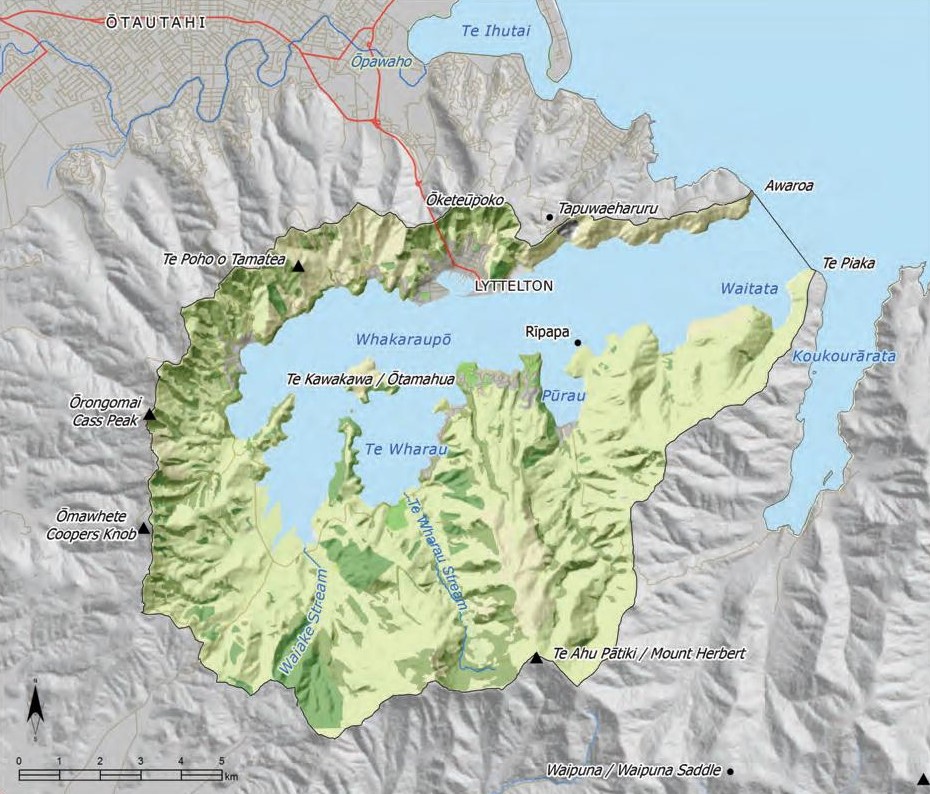
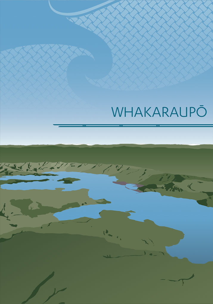
IMP: Ngā Take ā-hikawai Me Ngā Kaupapa | Catchments

6.6 Whakaraupō

Wāhi Tuaono | Part 6

6.6 Whakaraupō [WH]

Whakaraupo

This section addresses issues of particular significance in the Whakaraupō (Lyttelton Harbour) catchment (Map 15).

Whakaraupō has a rich history of Ngāi Tahu land use and occupancy, and strong tradition of mahinga kai. The harbour was named after the raupō reeds that were once plentiful at Ōhinetahi at the head of the harbour. Kaimoana such as pipi, tuaki, kutai, pāua, tio, kina and pūpū, and ika such as pātiki, pātiki rori, pīoki, hoka, aua, pāpaki, koiro and hokarari provided an abundant and reliable supply of mahinga kai for tāngata whenua and their manuhiri. The restoration of kaimoana values to the Whakaraupō is a key kaupapa for the kaitiaki Rūnanga in this catchment.

Whakaraupō is part of Te Tai o Mahaanui (SelwynBanks Peninsula Coastal Marine Area) Coastal Statutory Acknowledgement Area), as per schedule 101 of the TSCA 1998 (see Appendix 7).

"Tāngata whenua know the Harbour very well. Many generations of whānau knowledge provide a base upon which the present residents exercise their kaitiakitanga in both traditional and contemporary ways." (1)

Map 15: Whakaraupō

Lyttleton Harbour

NOTE: See Section 5.1 (Issue K1 - Recognising Manawhenua) for guidance on identifying the Papatipu Rūnanga with manawhenua and kaitiaki interests in this area.

Ngā Paetae | Objectives

(1) Restoration of the cultural health of Whakaraupō, including elimination of wastewater discharges, reducing sedimentation and achieving a water quality standard consistent with the Harbour as mahinga kai.
(2) The wāhi taonga status of the catchment’s waterways and waipuna is recognised and provided for.
(3) Natural and cultural landscape values associated with the Whakaraupō catchment are enhanced through restoration of indigenous biodiversity values.
(4) Tāngata whenua continue to contribute to, and influence, community issues and projects within the catchment.
(5) Sites and places of cultural significance, including wāhi tapu and wāhi taonga, are protected from inappropriate land use and development.
(6) Kaimoana is managed according to Ngāi Tahu values and tikanga, enabling the sustainable customary harvest of these resources in Whakaraupō.

Ngā Take | Issues of Significance

WH1: Cultural Health of Harbour

Issue WH1: The cultural health of the harbour is at risk as aresult of:
(a) Discharge of wastewater;
(b) Sedimentation;
(c) Stormwater run off;
(d) Inflow from streams carrying increased sediment and nutrient loads.

Ngā Kaupapa / Policy

WH1.1 To require that Whakaraupō is recognised and provided for as a cultural landscape of historical, spiritual, traditional and customary significance.

WH1.2 To require that Whakaraupō is managed for mahinga kai first and foremost. This means:
(a) All proposed activities for the lands and waters of Whakaraupō are assessed for consistency with the objective of managing the harbour for mahinga kai. We should be asking, “How does this activity affect the harbour?” and adjust accordingly; and
(b) Water quality in Whakaraupō is consistent with the protecting mahinga kai habitat and enabling customary use (whole of harbour not just designated areas).

WH1.3 To recognise Whakaraupō as a working port and harbour, and to build relationships and develop clear strategies that enable these activities to occur alongside managing the Harbour for mahinga kai.


Holistic approach to management

WH1.4
To adopt a holistic approach to restoring the cultural health of Whakaraupō. This means:
(a) Recognising the cumulative effects of all activities on the cultural health of the harbour;
(b) Recognising and providing for the relationship between land use and the cultural health of the harbour; and
(c) Collaboration and integration of efforts between local authorities, Ngāi Tahu, the community, and other agencies and organisations.


Wastewater discharge

WH1.5
To require the elimination of the discharge of wastewater to Whakaraupō, as this is inconsistent with Ngāi Tahu tikanga and the use of the harbour as mahinga kai.

WH1.6 To require, until such time as wastewater discharges are eliminated from Whakaraupō:
(a) Initiatives and incentives to reduce the volume of wastewater entering the system, as per general policy on Waste management (Section 5.4, Issue P7);
(b) Limits on subdivision and building activity, to avoid further connections to existing infrastructure;
(c) Ongoing monitoring of nutrient concentrations in wastewater and in Harbour water; and
(d) Discharge on outgoing tide only to achieve greater dilution and dispersal.


Sedimentation

WH1.7 To advocate that local authorities develop a regional management strategy for addressing soil loss in the Whakaraupō catchment, and sedimentation of the harbour. The strategy to include:
(a) Identification of those land use activities that are contributing to sedimentation;
(b) Effective and enforceable controls on those activities to minimise sedimentation and contamination of waterways and coastal waters; and
(c) Incentives to promote reforestation (with native species), riparian margin enhancement and soil conservation as measures to address sedimentation of the harbour.

WH1.8 To investigate the feasibility of dredging the areas at the Head of the Bay where sedimentation and infilling is having effects on mahinga kai habitat quality.


Cultural monitoring

WH1.9 To formalise a program of cultural monitoring (State of the Takiwā) of the health of Whakaraupō, with a focus on:
(a) Quality of mahinga kai habitat;
(b) Species diversity and abundance;
(c) Water quality; and
(d) Suitability of traditional mahinga kai areas for customary use.


Priority Areas

WH1.10 To investigate options and opportunities to restore the salt marsh at the Head of the Harbour as a mahinga kai habitat and kōhanga as a matter of priority. The name Whakaraupō comes from the raupō reeds that were once plentiful at Ōhinetahi at the head of the harbour.

He Kupu Whakamāhukihuki / Explanation

Restoration of the cultural health of Whakaraupō is a priority objective for tāngata whenua. The cultural impact of pollution and sedimentation on the harbour and its mahinga kai resources is significant. Restoring cultural health is about restoring the mauri of the harbour and the mana of the people. Until recent years, Rāpaki was known widely for the kaimoana available to the community for its own use – and to host visitors. Decline in the available quantities and quality of kaimoana because of the deteriorating marine environment have prevented tāngata whenua from exercising their cultural values such as manaakitanga.(2)

"Our goal for the waters of Whakaraupō is to restore the harbour to the state it was before deforestation, sewage discharges and other activities degraded it. The long term goal is to restore the harbour to a state where the kaimoana return and we can once again harvest mahinga kai without cultural, environmental and health concerns."

"A lifestyle has been taken from us - gathering our kai. I can’t take my mokopuna down to the beach to gather kai in case we get sick."

"Our kaupapa is the quality of our water."

The discharge of wastewater from sewage treatment plants contributes significant volumes of high nutrient effluent to the harbour. While this activity will cease in the next 5-8 years when existing resource consents expire, tāngata whenua continue to advocate for measures to limit the volume of wastewater entering the existing system, including avoiding further connections. Sedimentation is also a key contributor to the poor cultural health of Whakaraupō. Historical deforestation, inappropriate land use practices and urban development have de-stabilised soils and accelerated erosion of the highly erodible Port Hills loess soils. Catchment erosion is recognised a significant external source of sediment to the harbour and the source of the infilling of intertidal mudflat areas (see Box – Sedimentation and Whakaraupō).

A community based approach based on the principle of Ki Uta Ki Tai is required to address the impacts of land use and other activities on the cultural health of the harbour. A key feature of a holistic approach is working with the wider community to establish positive cultural relationships and ensure good cultural, environmental and community outcomes. Tāngata whenua firmly believe that managing the harbour for mahinga kai can recognise and provide for multiple uses and values, while protecting and restoring this tribal taonga.

"The local kaitiaki and the community know what’s best for a local place."

"Where do we start? At the top of the hill and work our way down to the harbour. We look at every waterway, every little ephemeral stream. And we go from there."

Sedimentation and Whakaraupō

The need for improved information and understanding of the effects of sedimentation on the harbour and mahinga kai is a priority area for tāngata whenua.

Primary sources of sedimentation in the harbour as identified by tāngata whenua include:

  • Accelerated erosion of highly sensitive soils;

  • Stock access to waterways, including ephemeral waterways;

  • Sediment loads in waterways;

  • Earthworks associated with subdivision and urban development;

  • Dredging and reclamation activities;

  • Coastal structures such as breakwaters that change tidal patterns; and

  • Stormwater run off from roadworks and slips.

Cross reference:

» Issue WH2: Lyttelton Port Company activities
» General policy on waste management (Section 5.4, Issue P7)
» Section 6.5 (Ihutai), Issue IH3

WH2: Lyttleton Port Company (LPC) Activities

Issue WH2: The need to work closely with LPC to manage effects of port activities on the cultural health of the harbour and the relationship of tāngata whenua to it, in particular:
(a) Inner harbour activities, and expansion of these activities;
(b) Changes to tidal flows, ebbs and flushes as a result of structures and/or landfill in the harbour (e.g. breakwaters);
(c) Disposal of dredge spoil;
(d) Biosecurity risks.

Ngā Kaupapa / Policy

Relationships

WH2.1 To continue to maintain a good working relationship between tāngata whenua and the LPC to address cultural issues and achieve positive cultural, environmental and economic outcomes.

WH2.2 To require that the relationship between tāngata whenua and the LPC reflects the spirit of a Treaty relationship.

WH2.3 To investigate the feasibility of having a Papatipu Rūnanga representative appointed to the LPC Planning Board.


Cultural effects

WH2.4
To require that LPC recognise and provide for the relationship of Ngāi Tahu to Whakaraupō, and aspirations to manage the harbour as mahinga kai, by:
(a) Ensuring that port activities avoid contributing to pollution in the outer harbour;
(b) Ensuring that port activities at all times seek to avoid or minimise pollution in the inner harbour; and
(c) Providing appropriate mitigation and/or compensation where cultural and environmental effects cannot be avoided, including but not limited to:
(i) Funds for restoration projects.

WH2.5 To work with LPC on the following issues of cultural concern and significance:

(a) The need for a research program to investigate and address how dredging, reclamation, sedimentation and structures in the harbour are affecting mahinga kai, including the potential effects of breakwaters on the ability of tidal flows to flush the harbour of sediment, and the resultant accumulation of sediment on kaimoana beds at Rāpaki;
(b) The need for an alternative location for the disposal of dredging soil. Disposal of spoil along the northern edge of the harbour is contrary to cultural interests and objectives for improving the Whakaraupō marine environment, and may be adversely affecting Te Ara Whānui o Makawhiua (Koukourārata); and
(c) The feasibility of dredging the mudflat areas at the Head of the Harbour, where sediment build up and infilling is having significant cultural and environment impact.

WH2.6 To require effective marine rules to protect Whakaraupō from the effects of discharges associated with ballast, bilge and sewage from ships and boats, including biosecurity risks.

He Kupu Whakamāhukihuki / Explanation

Tāngata whenua accept that Lyttelton is an important working port for the South Island, providing significant economic benefits for the community and region. However, it is important to manage the effects of LPC activities on the cultural health of the Whakaraupō, and on Ngāi Tahu and community values. Whakaraupō as a working port and harbour does not have to be inconsistent with managing the harbour for mahinga kai (see Issue WH1).

Tāngata whenua have worked with LPC on a number of proposals for various activities in the inner harbour. These include deepening the main channel, extending the reclaimed area, changing the function of the inner harbour, removal of toxic materials form the harbour floor and recovery from the earthquake damage. In each case, LPC and tāngata whenua have worked together to identify and address cultural issues.

"We believe that reclamation is having an affect on kaimoana beds. The harbour isn’t able to ‘flush’ itself. There used to be a good flow coming up the harbour to flush the kaimoana beds, but this doesn’t happen anymore."

"One of the questions we need to ask is: Is there more sedimentation coming into the harbour, or is there less sediment leaving the harbour, or both?"

WH3: Waterways and Waipuna

Issue WH3: The protection and enhancement of waterways and waipuna is essential to improving the cultural health of the catchment.

Ngā Kaupapa / Policy


Waipuna

WH3.1 To require that all waipuna of Ngā Kōhatu Whakarakaraka o Tamatea Pōkai Whenua (the Port Hills) are recognised and managed as wāhi taonga, as per general policy on Wetlands, waipuna and riparian margins (Section 5.3 Issue WM13).

Waterways

WH3.2 To require that all waterways of Ngā Kōhatu Whakarakaraka o Tamatea Pōkai Whenua are recognised and provided for as wāhi taonga, in particular:
(a) Te Wharau;
(b) Pūrau;
(c) Waiake;
(d) Ōmaru;
(f) Zephyr;
(e) Living Springs; and
(g) Taukahara.

WH3.3 To continue to initiate, support and undertake waterway restoration projects in the catchment, including the lower reaches of Ōmaru, the local stream at Rāpaki.

WH3.4 To address the impacts of stock access to waterways (i.e. sedimentation and effluent discharge) by:
(a) Prohibiting stock access to waterways in the catchment, including ephemeral streams;
(b) Advocating for less stock overall on the hills surrounding the harbour; and
(c) Advocating for removal of cattle from some areas of the hills surrounding the harbour, to enable reforestation with low impact sheep grazing.

WH3.5 To require stringent and enforceable controls on land use and earthworks activities as part of the resource consent process, to protect waterways from sedimentation.

He Kupu Whakamāhukihuki / Explanation

Whakaraupō is surrounded by steep hills and valleys incised by numerous permanent and ephemeral streams. The soils of the catchment are particularly sensitive to land use and vegetation clearance, and local streams can carry high sediment and nutrient loads. Degraded or the lack of planted riparian margins reduce the ability of waterways to capture and filter sediment.

"One of the best ways we can pay tribute to our old people is to work to improve the water quality and the health of our waterways."

Ōmaru Puna Wai

Ōmaru puna wai was registered with the NZHPT as a wāhi tapu in 2005. The site is located on the ‘Whaitiri block’ (Rapaki MR 875 Lot 9/sec 46.)

Ōmaru puna wai is a Wāhi Tapu in the traditional, spiritual and mythological senses. The puna wai (spring) flows into the Ōmaru Stream, which is sourced at the foot of the hill named Te Poho o Tamatea (the bosom of Tamatea Pokai Whenua, captain of the Takitimu waka). The hill’s name derives from when Tamatea recited karakia at its peak, causing fire to erupt from Mount Ngaruhoe in the north. The fire travelled to Te Waipounamu to relieve Tamatea’s cold and suffering in this new and hostile environment. Thus the stream and puna wai are sites of mythological significance associated with the footprint of Tamatea Pokai Whenua.

The puna wai is also of immense traditional and historical significance to whānau. While other natural springs existed in the bay, these passed through an old urupā and were therefore considered tapu. The only other natural spring in Rāpaki Bay emerges on the sandy beachfront and is therefore not of a sufficient quantity or quality to be consumed or utilised in ritual.

Historically, fresh water was collected from Ōmaru Puna Wai in large containers and carted back to the marae by horse. The water was made available for consumption or transported to the urupā for cleansing to whakanoa peo- ple returning from the urupā during tangi, etc. Whānau from the kaitiaki runanga and the owners of the Whaitiri block intend to reinstate the ritual use of the puna, for tangihanga, burial of whenua, pito and other uses.

The restoration of the puna wai as part of the broader restoration programme for the Ōmaru Stream. The equilibrium of the stream and puna wai has been affected over the years by farming activities in the upper catchment. Restoration will involve acknowledging

the holistic attributes which support the mauri of the stream and puna wai. Balancing the physical, biological and spiritual values are critical success factors to the restoration process.

Sources: Wāhi tapu registration proposal for Ōmaru Puna Wai (NZHPT); personal communication Amos Kamo.

Cross reference:

» Issue WH4: Soil conservation
» Issue WH6: Coastal land development

WH4: Soil Conservation

Issue WH4: The mauri of soils in the catchment is at risk from historical and contemporary land use practices.

Ngā Kaupapa / Policy


WH4.1 To require that the sensitivity of the soils on the hills around Whakaraupō to erosion is recognised and provided for in land management and consenting processes.

WH4.2
To require the identification of those catchments that are experiencing the highest rates of soil loss, and the activities or land practices that are contributing to this loss, as a matter of priority.

WH4.3
To require stringent and enforceable controls on land use and earthworks activities as part of the resource consent process, to protect soil resources from further degradation and loss.

WH4.4 To support and encourage the restoration and protection of indigenous vegetation, including riparian margins, as part of conserving soil resources.

He Kupu Whakamāhukihuki / Explanation

Erosion and soil loss is a significant issue in the Whakaraupō catchment, particularly the influx of sediment in the harbour and the infilling of mudflat areas. The soils of the steep hills that surround the harbour are predominately greywacke loess, and are vulnerable to erosion as a result of vegetation clearance, earthworks, urban development and other human activity. Soil conservation is the primary measure to protect the mauri of soils and reduce sedimentation into waterways and the harbour. It is critical that land use activities in the catchment match the nature of the land (e.g. soil type, elevation, slope) in order to protect soil resources.

The nature of our soils on the hills means we have to be vigilant about stormwater.”

Cross reference:

» Issue WH6: Subdivision and coastal land development
» General Policy on Papatūānuku (Section 5.4, Issue P1)
» General Policy on soil conservation (Section 5.4, Issue P9)

WH5: Tools to Protect Customary Fisheries

Issue WH5: Appropriate management tools are required to protect and enhance customary fisheries and the marine environment.

Ngā Kaupapa / Policy

Rāpaki Mātaitai Reserve

WH5.1
To continue to manage the Rāpaki Mātaitai Reserve according to its management aim:
(a) To maintain and improve the local fishery, and to ensure the sustainability of the resources and its environment with the local community, hoping it will help return the bay to its former healthy state.

WH5.2 To require that the key management mechanisms for the Mātaitai Reserve are recognised and adhered to:
(a) Gazetted tāngata tiaki/kaitiaki, who are responsible for the management of the Mātaitai Reserve; and
(b) Bylaws to manage fishing in the reserve, and enhance fish stocks.


Whakaraupō as mahinga kai


WH5.3 Tāngata whenua intend to work to extend the mātaitai over the whole of the harbour, consistent with aspirations to manage the Whakaraupō as mahinga kai.

WH5.4 To require that water quality in the harbour is such that tāngata whenua can exercise customary rights to safely harvest kaimoana.

WH5.5 To support an ongoing programme of water and kaimoana testing in the harbour.

WH5.6 To continue to use rāhui to protect particular species to allow stocks to recover, including areas that have been reseeded.

He Kupu Whakamāhukihuki / Explanation

The primary emphasis for tāngata whenua with regard to the relationship with Whakaraupō is kaimoana, and therefore the environment within which the kaimoana lives. This means that appropriate management tools are required to protect the marine environment. For Ngāi Tahu, the most appropriate tools are customary management tools, supported by mātauranga Māori and science. An example is the prohibition on the taking of paua to allow the stock to recover, and the use of a rāhui in 2008 to protect an area reseeded with cockles brought in from Ōtakou.(3)

During the lifetime of Rāpaki tāua and pōua, pollution of Whakaraupō has resulted in the inability of Rāpaki residents and their visitors to eat Whakaraupō shellfish such as: pipi, tūaki, kūtai, pāua, tīo, kina and pūpū. Two generations ago there were also sufficient supplies of ika such as: pātiki, pātiki rori, pīoke, hoka, aua, pāpaki, koiro and hokarari to provide regular food for those living at Rāpaki. No longer is this possible. (4)

The Rāpaki Mātaitai Reserve was established in 1998 as the country’s first mātaitai reserve. The purpose of the reserve is to protect the customary fisheries resource (for more information on mātaitai and a map of the Rāpaki Mātaitai see Section 5.6 Issue TAN4).

“Our intention is to have a mātaitai reserve over the whole of Whakaraupō.”

Cross reference:

» General policy on Tools to protect customary fisheries and the marine environment (Section 5.6. Issue TAN4)

WH6: Subdivision and Coastal Land Development

Issue WH6: Settlement expansion, coastal land development and the conversion of rural land to residential can have effects on the relationship of tāngata whenua with Whakaraupō, including but not limited to:
(a) Adding to the volume of wastewater discharged to the harbour;
(b) Increasing sedimentation of waterways and harbour waters;
(c) Risk to culturally important landscape features such as headlands and ridge lines;
(d) Risk of disturbance or damage to significant sites, including silent files; and
(e) Restricting tāngata whenua access to the coast.

Ngā Kaupapa / Policy

WH6.1
To use the following principles as a guide for assessing subdivision and development on land surrounding Whakaraupō:
(a) Retain the rural environment and keep small communities small;
(b) Concentrate settlements in areas able to absorb change;
(c) Concentrate urban development around a ‘middle band’ around the harbour, therefore avoiding impact on the peaks and ridge lines, and on the coast; and
(d) Recognise that there may be “no-go areas” that need to be protected from development.

WH6.2 To require stringent and enforceable controls on land use and earthworks activities as part of the resource consent process, to protect waterways from sedimentation.

WH6.3 To advocate for a limit on all new residential land developments until wastewater discharges to the harbour cease.

WH6.4 To assess subdivision and residential and coastal land development proposals with reference to general policy on Subdivision and development (Section 5.4 Issue P4) and Coastal land use and development (Section 5.6 Issue TAN7), with particular attention to:
(a) Requiring that developers have plans in place for:
(i) Stormwater infrastructure - stormwater must be clean before it hits the harbour;
(ii) Protection of local streams; and
(iii) Erosion and sedimentation control, including minimising the area of land cleared and left bare at any given time.

WH6.5 To ensure that coastal land use and development does not restrict or prevent access to the harbour.

WH6.6 To advocate for the protection of paper roads, in recognition of the reason that they were established: to enable public access to streams and the foreshore.

WH6.7 To work with the community and local government to address the following matters of priority during the Lyttelton re-build:
(a) Improvement of existing stormwater infrastructure (as this has impacts on the Harbour); and
(b) Recognition of the relationship between tāngata whenua and Lyttelton.

He Kupu Whakamāhukihuki / Explanation

Policies WH6.1 to WH6.6 are intended to minimise the effects of subdivision, residential land development and coastal development on Whakaraupō and tāngata whenua values. There is an increasing demand for development in the catchment, but a lack of appropriate wastewater and stormwater infrastructure to support this.

Tāngata whenua want to see a limit on development until wastewater discharges to the harbour cease. More development equals more people and therefore more wastewater into the harbour. Subdivision consents continue to be granted without the appropriate infrastructure in place to support the increased population. For example, the Governors Bay sewage treatment facility does not have the capacity for all of the sections being developed in the area.

Sedimentation is a further concern with regard to subdivision and development activities. Vegetation clearance and earthworks increases the risk of sediment and contaminants entering local waterways and the harbour.

“The threat of inappropriate coastal development is something we constantly monitor.”

The Queen’s chain is important. It goes right around the harbour. The Queen’s chain and paper roads guarantee access to the coast and sea.”

Cross reference:

» Issue WH4: Soil conservation
» Issue WH7: Protection of cultural landscape values » General policy on subdivision and development (Section 5.4, Issue P4)
» General policy on coastal land use and development (Section 5.6, Issue TAN7)

WH7: Cultural Landscape Values

Issue WH7: Protection of wāhi tapu, wāhi taonga and other cultural landscape values from inappropriate subdivision, land use and development.

Ngā Kaupapa / Policy

WH7.1 To adopt a cultural landscape approach to identify and protect wāhi tapu and wāhi taonga from the adverse effects of land use, subdivision and development in the Whakaraupō catchment.

WH7.2 To use the methods set out in general policy on Cultural landscapes, Wāhi tapu me wāhi taonga, and Silent files (Section 5.8, Issues CL1, CL3, and CL4) to protect wāhi tapu and wāhi taonga in the catchment from inappropriate land use, subdivision and development.

WH7.3 To require that potential effects on wāhi tapu and wāhi taonga be fully and effectively assessed as part of all resource consent applications associated with the Whakaraupō catchment.

He Kupu Whakamāhukihuki / Explanation

Whakaraupō is a cultural landscape with important mahinga kai, wāhi taonga and wāhi tapu associations. The protection of wāhi tapu and wāhi taonga is an essential part of recognising and providing for the relationship of tāngata whenua with this catchment.

There are three silent files associated with Whakaraupō: 030 at Governors Bay, 031 at Rāpaki, and 032 at Little Port Cooper and Te Piaka/Adderley Head (See Appendix 6 for a Schedule of silent file maps). The silent file areas include both land and water. Silent files remain an important mechanism for protecting wāhi tapu values in this area.

“We continue to care for the places on the hills that hold our history.”

Cross reference:»

» General policies in Section 5.8 – Issue CL1: Cultural landscapes; Issue CL2: Ngāi Tahu Cultural Mapping Project; Issue CL3: Wāhi tapu me wāhi taonga; and Issue CL4: Silent files

WH8: Indigenous Biodiversity

Issue WH8: Enhancing natural and cultural landscape values, including mahinga kai, through protecting and restoring indigenous biodiversity.

Ngā Kaupapa / Policy

WH8.1 To initiate and support initiatives for restoration efforts in the catchment, with particular emphasis on:
(a) Waterways;
(b) Species valued for mahinga kai and other cultural use;
(c) Areas of high erosion/soil loss;
(d) Creating corridors between each site/project/ existing native vegetation/remnants; and
(e) Protection of endemic species.

He Kupu Whakamāhukihuki / Explanation

Enhancing natural landscape values is a significant kaupapa for tāngata whenua in this catchment. Land clearance for farming, settlement and roading has impacted on the abundance and diversity of native vegetation, and along with it, native birdlife. Restoring indigenous biodiversity enhances the health of the land and the restores important cultural associations to place.

Cross reference:

» General policies in Section 5.5 – Issue TM2: Indigenous biodiversity; and Issue TM3: Restoration of indigenous biodiversity

WH9: Reserves and Open Space Management

Issue WH9: Ensuring that public open space (i.e. parks and reserves) is managed in way that recognises and provides for tāngata whenua values and interests.

Ngā Kaupapa / Policy

WH9.1 To work with and alongside the local council and community to manage the Reserves of Ngā Kōhatu Whakarakaraka o Tamatea Pōkai Whenua with a long term objective of:
(a) Restoration of the indigenous biodiversity of these areas; and
(b) Increasing indigenous biodiversity values in the catchment as a whole.

WH9.2 To encourage the recognition of the relationship between tāngata whenua and Ngā Kōhatu Whakarakaraka o Tamatea Pōkai Whenua and Whakaraupō in parks, reserves and other open space), including but not limited to the use of:
(a) Pou whenua;
(b) Ingoa wāhi;
(c) Interpretation panels; and
(d) Ngāi Tahu artwork.

He Kupu Whakamāhukihuki / Explanation

There are numerous reserves in the Whakaraupō catchment, largely associated Ngā Kōhatu Whakarakaraka o Tamatea Pōkai Whenua. It is important that reserve and open space management recognises and provides for kaitiakitanga through the involvement of tāngata whenua, and the use of physical markers on the landscape acknowledging Ngāi Tahu historical and contemporary associations with the landscape.

Cross reference:

» Issue WH10: Islands
» General policy on restoration of indigenous biodiversity (Section 5.5 Issue TM3)
» General policy on Ngāi Tahu tikanga tūturu (Section 5.4 Issue CL7)

WH10: Islands

Issue WH10: Ngāi Tahu values associated with islands of Whakaraupō.

Ngā Kaupapa / Policy

WH10.1 To continue to work with the Department of Conservation on the management of island reserves in Whakaraupō, including:
(a) Ngāi Tahu contributions to management plans and setting of management priorities and objectives;
(b) Restoration of indigenous biodiversity;
(c) Pest control;
(d) Interpretation and appropriate visitor use; and
(e) Protection of Ngāi Tahu values such as archaeological sites.


Rīpapa


WH10.2
To require that Rīpapa is recognised as a wāhi tapu.

WH10.3
To continue to work with the Department of Conservation to manage and restore Rīpapa Island.

WH10.4
To require that Ngāi Tahu values are recognised and provided for in all management and conservation activities on Rīpapa island, as per sections 241 and 242 of the NTCSA 1998 (Tōpuni).

WH10.5 To continue to encourage understanding of and respect for Ngāi Tahu cultural, historical and spiritual values associated with Rīpapa Island.


Ōtamahua


WH10.6
To continue to support, and be involved with, the Ōtamahua/Quail Island Ecological Restoration Trust.


Aue


WH10.7
To monitor the island for disturbance to archaeological sites as a result of tree windthrow.

WH10.8 To work with the Department of Conservation to determine appropriate management strategies for:
(a) Pest control;
(b) Future of exotic trees; and
(c) Protection of archeological sites.

He Kupu Whakamāhukihuki / Explanation

There are three islands in Whakaraupō: Rīpapa, Ōtamahua (Quail Island) and Aue (King Billy Island), and each is classified as a different type of reserve (see Box – Reserves established under the Reserves Act 1977). These places have a range of cultural values and associations. Rīpapa is a wāhi tapu and a Tōpuni site. The island was the pā of Taununu, a leading Ngāi Tahu warrior in the 1820s (see Appendix 7 – Schedule 88, NTCSA 1998 for more information). Rīpapa Island is now a Historic Reserve.

Ōtamahua means ‘the place where children collect sea birds’ eggs’. Ngāi Tahu historically used the island as a base to gather eggs and kaimoana. An earlier name for the island was Kawakawa, after the highly valued native shrub that grew there. Ōtamahua is a now a Recreation Reserve.

Aue, or King Billy Island, was a source of fine sandstone. Ngāi Tahu collected the sandstone to use for grinding and polishing pounamu/greenstone. The island is now a Scenic Reserve.

Historic Reserves, Recreation Reserves and Scenic Reserves are established under the Reserves Act 1977.

Historic Reserves are established primarily to protect and preserve in perpetuity places, objects and natural features of historic, archaeological, cultural, educational and other special interest. Rīpapa Island is a Historic Reserve.

Recreation Reserves provide areas for recreation and sporting activities. This is to provide for the physical welfare and enjoyment of the public and for protection of the natural environment and beauty. Ōtamahua is a Recreation Reserve.

Scenic Reserves are established to protect and preserve in perpetuity, for their intrinsic worth and for the public benefit, enjoyment and use, such qualities of scenic interest or beauty or natural features worthy of protection in the public interest. Aue is a Scenic Reserve.

WH11: Structures in the Marine Coastal Area

Issue WH11: The potential for too many coastal structures in the harbour.

Ngā Kaupapa / Policy

WH11.1 To consider all structures in the coastal marine area on a case by case basis, assessed on:
(a) Purpose (e.g. private or community);
(b) Effects on mahinga kai;
(c) Effects on the marine environment; and
(d) Cumulative effects.

Moorings

WH11.2
As a general principle:
(a) To maintain the level of existing moorings in Whakaraupō as opposed to increasing the density; and
(b) Moorings should remain concentrated in areas where they already exist.

He Kupu Whakamāhukihuki / Explanation

Whakaraupō has significant recreational value for the community. However, recreational use should not compromise Ngāi Tahu customary values and interests associated with the harbour.

Tāngata whenua have a particular interest in ensuring that structures in the coastal marine area do not affect mahinga kai resources and use of the bay for mahinga kai purposes.

END NOTES / REFERENCES

1. Couch, D.W., 2003. Cultural Impact Assessment: Lyttelton Seabed Contamination, p.8.
2. Ibid.
3. Couch, D.W., 2008. In: Te Karaka. Issue 43, p. 27.
4. Couch, D.W., 2003. Cultural Impact Assessment: Lyttelton Seabed Contamination.