IMP: Ngā Take ā-hikawai Me Ngā Kaupapa | Catchments

6.8 Akaroa Harbour

Wāhi Tuaono | Part 6

6.8 Akaroa Harbour [A]

Akaroa Harbour

This section of the IMP addresses issues of particular
significance in the catchment of Akaroa Harbour (Map 17). Ngāi Tahu culture, history and identity is strongly embedded in the land and seascapes of this catchment. The Harbour is part of Te Tai o Mahaanui, the Selwyn – Banks Peninsula Coastal Marine area Statutory Acknowledgement (See
Appendix 7). Ngāi Tahu oral traditions explain the creation
of Akaroa Harbour:

Our oral traditions of Te Ukura (maunga that stands on the
western side of Akaroa Harbour, overlooking Ōnawe) recall
the establishment of the ley-lines to Rāpaki, Tūwharetoa and Te Arawa through the deeds of Tamatea-Pokaiwhenua and are linked to the Takitimu oral traditions.

These oral traditions tell of Tamatea and his people’s
Southern expedition resulting in the Takitimu floundering
in the Murihiku area. As they returned to their home in the
North Island Tamatea and his people travelled up the East
Coast of the South Island arriving at Rāpaki.

Overcome by the cold, Tamatea summoned fire to warm his
people from Ngātorirangi through karakia. Oral tradition
recalls that Ngātorirangi sent fire in the form of two fireballs one from Ruapehu and the other from Ngauruhoe. On their journey south the fireballs merged into one fireball.

Upon reaching the Te Irika o Kahukura also known as Kā Kōhatu Whakarakaraka a Tamatea-Pokaiwhenua, the fireball broke back into two fireballs. The first fireball continued down the slope carving out Te Whakatakaka-o-te-karehuo-te ahi-Tamatea and Whakaraupō (known today as Lyttelton Harbour). The second fireball continued eastward landing at Te Ukura and carved out Whakaroa (known today as Akaroa Harbour).

The fire having warmed Tamatea and his people, remains today in the form of thermal spots around the Lyttelton Harbour and are known to our people for their therapeutic and mahinga kai values.

Now warmed Tamatea and his roopū continued their journey north eventually arriving at Ōhinemutu where they gave Ngātorirangi “Te Mauri o te Mātao” in exchange for the fireballs he had sent. This mauri was placed at Ōhinemutu where it remains today and became the basis of the solidification of the volcanic plateau. (1)

Map 17: Akaroa Harbour

Akaroa Harbour

NOTE: See Section 5.1 (Issue K1 - Recognising Manawhenua) for guidance on identifying the Papatipu Rūnanga with manawhenua and kaitiaki interests in this area.

Ngā Paetae | Objectives

(1) Elimination of discharges of contaminants to Akaroa Harbour.
(2) Integrated approach to the management and development of Akaroa Harbour, based on the principle of Ki Uta Ki Tai and recognising the relationship between land use and coastal waters.
(3) Ngāi Tahu, as tāngata whenua, are strongly involved in planning and decision making for the land, waters and historic and cultural heritage of Akaroa Harbour.
(4) Customary fisheries and the marine environment of Akaroa Harbour are maintained and enhanced mō tātou, ā, mō kā uri ā muri ake nei, through the use of tikanga based fisheries management tools.
(5) Akaroa Harbour is recognised and provided for as a Ngāi Tahu cultural landscape, and territorial and regional plans and policies reflect this.

Ngā Take | Issues of Significance

A1: Discharge of Wastewater into the Harbour

Issue A1: The discharge of wastewater into the harbour is culturally offensive and incompatible with the harbour as mahinga kai.

Ngā Kaupapa / Policy

Reducing volume of wastewater

A1.1 To support incentives and initiatives to reduce the volume of wastewater entering the system, as per general policy on Waste management (Section 5.4, Issue P7), including but not limited to:
(a) Requiring on site stormwater treatment and disposal to avoid stormwater entering the wastewater system.


Discharge to land

A1.2 To require the elimination of the discharge of wastewater to Akaroa Harbour, as this is inconsistent with Ngāi Tahu tikanga and the use of the harbour as mahinga kai. This includes:
(a) Direct discharge from treatment plants;
(b) Indirect discharge via land (run-off), surface waterways or groundwater; and
(c) Wastewater coming back into harbour with tides and currents (if pumping out of harbour via pipeline).

A1.3 Wastewater should be treated and irrigated to land; subject to the following conditions:
(a) Effluent is treated to the highest possible standard;
(b) The land used as a receiving environment is suited to the nature and volume of discharge, to avoid run off or groundwater contamination;
(c) The land used as a receiving environment is used productively, in a way that is conducive to assimilating waste, such as native or exotic timber plantation; and
(d) Monitoring programs include both water and soil, and include clear strategies for responding to negative monitoring results.

A1.4 To assess potential sites for discharge to land with the following considerations:
(a) Cultural landscape values;
(b) Slope of site;
(c) Proximity to surface waterways, wetlands, waipuna;
(d) Proximity to coast;
(e) Type of soil (assimilative capacity); and
(f) Current and potential land use.


Treatment plants

A1.5 To avoid locating a wastewater treatment plant at:
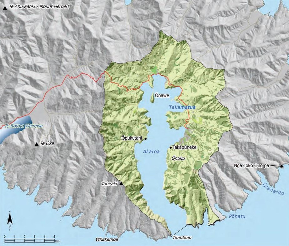
(a) Takapūneke;
(b) Near Ōnuku marae;
(c) Near waterways; or
(d) Near sites identified by tāngata whenua as wāhi tapu.


Holistic Approach

A1.6 To adopt a holistic and creative approach to finding a solution for wastewater management in the Akaroa Harbour area, including but not limited to:
(a) Recognising and providing for the cumulative effects of discharges on the harbour, as opposed to assessing effects of individual discharges;
(b) Minimising the volume of wastewater produced (Policy A1.1);
(c) Recognising and providing for future urban growth and rural land use change;
(d) Providing increased weight to cultural, social and environment costs and benefits, including costs to future generations; and
(e) Affording equal weighting to those cultural effects that may be intangible (e.g. effects on tikanga) with effects identified and measured by western science.

A1.7 If no local solution to wastewater can be found, then wastewater should be transported to Christchurch City and discharged via the existing ocean outfall.


Consent terms and monitoring

A1.8 To support the granting of short term consent of no more than 5 years, for renewal of consent for the discharge of wastewater to the harbour, to enable investigation, evaluation and development of discharge to land options.

A1.9 To require regular monitoring of the cultural health of the harbour, including sampling of kaimoana species at locations, until discharges of wastewater to the harbour cease.

He Kupu Whakamāhukihuki / Explanation

Wastewater treatment and disposal is one of the most significant issues in the Akaroa Harbour area. The primary concern is the discharge of wastewater directly into the harbour from treatment plants servicing reticulated system in the communities of Akaroa, Duvauchelle, Wainui and Tikao Bay. However, there is also a concern about poorly maintained or clustered septic tank systems in small communities.

The biggest issue in this area is sewage: we want to keep the harbour clean.”

The discharge of wastewater to the harbour is culturally offensive and inappropriate. Ngāi Tahu values associated with Akaroa Harbour are strongly focused on mahinga kai and the discharge of waste to water is inconsistent with these. The harbour is a Taiāpure Reserve, recognising the importance of the customary fishery, and tāngata whenua have aspirations to establish mātaitai as well (Issue A2). Tāngata whenua have observed that the upper harbour does not fully clear on every tidal cycle, and there are concerns about the cumulative effects of discharges in this part of the harbour. We would not put treated wastewater on our vegetable gardens so why would we discharge it to the sea where we get our mahinga kai?

We now must go further up the harbour to collect kaimoana that we know is clean and safe.”

When we were kids the mussels and paua were eaten raw; but not now. They are cooked because of contamination in the harbour.”

Policies A1.1 to A1.9 set out the cultural bottom lines associated with wastewater treatment and disposal and a framework for alternative options that are consistent with tāngata whenua aspirations for the harbour. An important kaupapa is that the cultural and environmental costs and benefits to current and future generations must be considered equally alongside economic costs (see Box - It is too expensive not to discharge to land).

Tāngata whenua recognise that discharge to land is complicated by the availability of suitable land, particularly given the amount of land needed to accommodate the excess volume of discharge that will occur in wet weather (stormwater overflow) and summer peak community populations. However, a creative and holistic approach that includes finding ways to eliminate stormwater contributions to the volume of wastewater entering treatment plants is a move in the right direction. For Ngāi Tahu, eliminating discharges of contaminants to Akaroa Harbour is in the interest of the community as a whole, and not just tāngata whenua.

For Ngāi Tahu, it is too expensive not to discharge to land

For Ngāi Tahu, it is too expensive not to discharge to land. The expense is not monetary; it is the environmental cost of not doing anything that we must be concerned with. This is an extremely sensitive issue for Ngāi Tahu. The cost to the environment, our takiwā and the loss of values for future generations far outweigh the dollars.

Cross reference

» General policy on waste management, (Section 5.4 Issue P7)
» Section 6.6 (Whakaraupō), Issue WH1
» Section 6.4 (Waimakariri), Issue WAI1
» Section 6.5 (Ihutai), Issue IH4

A2: Tools to Protect Customary Fisheries

Issue A2: Appropriate tools for protecting and enhancing the marine environment and customary fisheries.

Ngā Kaupapa / Policy

Reducing volume of wastewater

A2.1 To require that water quality in Akaroa Harbour is consistent with protecting and enhancing customary fisheries, and with enabling tāngata whenua to engage in mahinga kai activities.

A2.2 The Akaroa Taiāpure is a significant mechanism to protect the Akaroa Harbour marine environment and mahinga kai values.

A2.3 To continue to work with the wider community to implement the Akaroa Taiāpure.

A2.4 To investigate making an application to the Minister responsible for Fisheries under the Customary Fishing Regulations 1999 to establish mātaitai reserves on particular areas of Akaroa Harbour, recognising:
(a) The importance of particular areas as traditional fishing grounds and the need to provide for customary management practices and food gathering; and
(b) The need to protect marine based wāhi tapu and wāhi taonga (see Issue A10).

A2.5 To oppose the establishment of marine reserves in the Akaroa Harbour.

He Kupu Whakamāhukihuki / Explanation

A Taiāpure reserve was established in Akaroa Harbour in 2006. Taiāpure is a tikanga and community-based area management tool to protect the marine environment (see Section 5.6 Issue TAN4 for a description of Taiāpure, and Map 3 for the location map of the Akaroa Taiāpure). The Akaroa Taiāpure Committee includes representatives from Ngāi Tahu, local commercial and recreational fishing groups, and charter and tourist operators.

The vision for the Akaroa Taiāpure is to improve the sustainability of the customary fishery and create opportunities for future generations to continue to fish in the harbour, through a combination of western science and matauranga Māori based methods. For example, a project looking at the experimental translocation of pāua from Pōhatu Marine Reserve to Akaroa Harbour incorporates traditional Ngāi Tahu methods of putting pāua into kelp bags, transporting them to their new ocean location and letting them eat their way out of the bags.

“The best eyes on any coast line are the community’s. A taiapure should be a collaborative approach, like the Neighbourhood Watch of the sea. It’s not about taking a freezer full; it’s about taking enough for a feed so we can all use the sea.” (2)

“My grandfather used to take the little ones [paua] and leave the big ones for breeding. Now they take the big ones and don’t leave anything for breeding. If you allowed people to take the little ones today to save breeding stock, it wouldn’t work as they would just take everything.”

Tāngata whenua are also investigating the potential to establish mātaitai reserves on particular areas of the harbour, to complement the taiāpure and further protect customary fisheries.

Cross reference:

» General policy on tools to protect customary fisheries and the marine environment (Section 5.6, Issue TAN4)
» Issue A10: Ngā rohe wāhi tapu

A3: Urban, Rural and Coastal Subdivision and Development

Issue A3: Subdivision, settlement expansion and rural and coastal land development can have effects on the relationship of Ngāi Tahu with Akaroa Harbour, including but not limited to:
(a) Increased discharge of contaminants to waterways and the harbour;
(b) Risk to culturally important landscape features such as headlands and ridge lines; and
(c) Risk of disturbance or damage to significant sites, including wāhi tapu.

Ngā Kaupapa / Policy

General Principles
A3.1 To use the following principles as a guide for assessing subdivision and development on land surrounding Akaroa Harbour:
(a) Retain the rural environment and keep small communities small;
(b) Concentrate settlements in areas able to absorb change;
(c) Protect important unmodified and natural areas from inappropriate subdivision and development, given the importance of these areas to Ngāi Tahu cultural heritage values; and
(d) Recognise particular areas as “no-go areas” to be protected from development.

A3.2 To require that local authorities recognise and provide for the particular interest of Ngāi Tahu in coastal land development activities in the Akaroa Harbour catchment, as per general policy on Subdivision and Development (Section 5.4, Issue P4) and: (a) Ensure that engagement with tāngata whenua is not limited to silent file or wāhi tapu triggers.


Assessing subdivision and development proposals

A3.3 To assess subdivision and residential and coastal land development activities in the Akaroa Harbour catchment with reference to general policies on Subdivision and development (Section 5.4 Issue P4), with particular focus on:
(a) Precedence - will the activity set a precedent on the landscape?

(b) Potential effects on harbour water quality;
(c) Potential effects on cultural landscape values and significant sites;
(d) Infrastructure plans for water supply, stormwater and wastewater treatment and disposal;
(e) Sustainability provisions; and
(f) Potential effects on the view of significant landscapes from Ōnuku marae.

A3.4 To require that the management and consenting of subdivision and development activity in the Akaroa Harbour catchment does occur in isolation from the need to eliminate discharge of wastewater to the harbour.


Protecting wāhi tapu and wāhi taonga

A3.5 To recognise the following areas as exclusion, or ‘no-go’ areas for subdivision and coastal land development:
(a) Takapūneke;
(b) Takamatua (Red Point); and
(c) Ōnawe.


A3.6 To require a precautionary approach, with a high level of engagement with tāngata whenua, for urban, rural and coastal subdivision and development activity in the following areas:
(a) Areas identified by tāngata whenua as culturally significant, including existing silent files and areas considered equivalent to silent file areas (see Issue A10);
(b) The land above Ōnuku marae;
(c) The ridge line above Akaroa;
(d) Ridge lines on the western side of Akaroa Harbour; and
(e) Headlands and ridge lines in general.

A3.7 Any development in the areas identified in Policy A3.6 above must be consistent with the protection of Ngāi Tahu values and with Papatipu Rūnanga aspirations for the site/area.


Urban growth and development in Akaroa township

A3.8 To require that the Akaroa township is recognised and provided as a Ngāi Tahu cultural landscape, in addition to French and English heritage associations. This means:
(a) Working with Christchurch City Council, NZHPT, the Akaroa Civic Trust and the wider community to manage and protect the unique and shared historic heritage of Akaroa;
(b) Requiring that assessments of effects on the distinctive character, form and heritage of Akaroa includes assessments of effects on Ngāi Tahu cultural heritage values;
(c) Ensuring that district plan objectives, rules and design guidelines to protect the historic character and heritage of Akaroa do not limit the ability of Ngāi Tahu whānui to express their relationship to this important ancestral landscape; and
(d) Ensuring that district planning processes encourage and enable opportunities to recognise Ngāi Tahu culture, history and identity in the Akaroa Harbour catchment, particularly in public open space (e.g. artwork) and through the use of Ngāi Tahu names on natural features such as waterways.

He Kupu Whakamāhukihuki / Explanation

Urban growth in existing communities, and development pressure in rural areas are significant issues in the Akaroa Harbour catchment, particularly given ongoing issues with wastewater disposal (Issue A1).

For tāngata whenua it is not about opposing development. Rather, it is about ensuring that development is appropriate to the takiwā and avoids effects on cultural, environmental and community values. Settlement expansion, coastal land development, and rural land use change should be assessed on a case-by-case basis, guided by general principles (Policy A3.1) and according to a number of criteria (Policy A3.3). Given the immense traditional, historical and spiritual significance of Akaroa Harbour, it is critical that tāngata whenua are recognised in the decision making process regarding where and how development occurs.

“When we think about subdivision and development in the harbour we think, ‘can our land take it?’ This is the measure. It is not about no development, it is about making sure that the land and the Harbour are protected from adverse effects.”

We are not against development. We are against development that does not have the infrastructure and plans in place to address wastewater, water and stormwater issues.”

Whilst the colonial heritage of Akaroa is largely displayed in the built environment, the cultural heritage of Ngāi Tahu is strongly connected to and embedded in the natural environment and undeveloped areas, and therefore particular attention should be afforded to avoiding inappropriate land use, subdivision and development in these areas.” (3)

The future development of Akaroa is an issue of specific concern for tāngata whenua with regard to the protection of cultural and historic heritage. Ngāi Tahu cultural heritage is a part of what makes Akaroa unique, and efforts to retain the distinctive form and colonial character of Akaroa’s built environment should not occur in isolation from the protection and enhancement of Ngāi Tahu cultural heritage values.

Cross reference:

» Issue A10: Ngā rohe wāhi tapu
» General policy on subdivision development (Section 5.4 Issue P4)
» General policy on coastal land use and development (Section 5.6 Issue TAN7)
» General policy on Ngāi Tahu tikanga tūturu (Section 5.8 Issue CL7)

Information resources:

» Jolly, D., 2009. Cultural Values Report: Takamatua to Takapūneke. Prepared for Christchurch City Council at the request of Mahaanui Kurataiao Ltd.
» Akaroa Harbour Basin Settlements Study 2009. Christchurch City Council.

A4: Papakāinga Housing

Issue A4: Māori landowners should be able to build homes and establish kaumatua flats on Māori land at Ōnuku and Ōpukutahi.

Ngā Kaupapa / Policy

See general policy on Papakāinga, Section 5.4, Issue P5.

He Kupu Whakamāhukihuki / Explanation

As with other catchments covered in this IMP, papakāinga housing is an issue of importance in the Akaroa Harbour catchment. Owners of Māori land at Ōnuku and Ōpukutahi want to be able to build homes and live on their ancestral land. Council policies and rules for zoning and subdivision should enable and not impede this aspiration.

“In the 1960s and 1970s, my parents and grandparents tried to build at Ōnuku. They were told by council that they had to live at Akaroa, alongside the Europeans. They weren’t allowed a building permit to build at Ōnuku. Today, we still can’t go home and build on our land. The zoning rules prevent us from building.”

A5: Waterways and Waipuna

Issue A5: Effects on waterways and waipuna as a result of:
(a) Stormwater run-off;
(b) Indigenous riparian vegetation removal;
(c) Stock access;
(d) Abstractions associated with rural land use; and
(e) Sedimentation from earthworks and vegetation clearance activities.

Ngā Kaupapa / Policy

A5.1 To support the development of an Integrated catchment management plan (ICMP) for Akaroa Harbour to address water quality and quantity issues in the catchment, recognising and providing for:
(a) Mauri and mahinga kai as first order priorities;
(b) The relationship between groundwater and surface water; and
(c) The effects of land use on water quality and quantity.

A5.2 To require that water quality in the catchment is consistent with the objectives and policies set out in general policy on Water quality (Section 5.3 Issue WM6).

A5.3 To improve water quality in the Akaroa Harbour using the methods identified in general policies on Water quality (Section 5.3 Issue WM6), with particular focus on:
(a) Eliminating existing discharges of pollutants;
(b) Establishing native riparian buffer zones along all waterways and drains;
(c) Restoring degraded waipuna and wetlands;
(d) Requiring appropriate controls on land use to control sedimentation; and
(e) Prohibiting stock access to waterways, wetlands and waipuna.

A5.4 To require that waipuna in the Akaroa Harbour catchment are recognised and provided for as wāhi taonga, as per general policy on Wetlands, waipuna and riparian margins (Section 5.3 Issue WM13).

A5.5 To highlight the cultural significance of stream mouths along the edge of the harbour: areas where waterways flowing into the inner harbour meet the sea. Many of these areas were wetlands prior to reclamation for roads and other development, and were used by tāngata whenua for mahinga kai and the gathering of cultural materials.

Marae drinking water supply

A5.6 To work with local authorities to address those activities that are having adverse effects on the quality of marae drinking water supply, including:
(a) Stock access to, and sedimentation of, Te Awaiti stream.

He Kupu Whakamāhukihuki / Explanation

Waterways in the Akaroa Harbour catchment are important to Ngāi Tahu cultural heritage. While most waterways in the Akaroa region now carry European names, the original Ngāi Tahu names and histories of these waterways remain an important part of the cultural landscape.

“I have noticed that the creeks around Akaroa have less water in them than they use to.”

Abstractions, stock access and land use activities such as subdivision, development and forestry have effects on surface water quality and quantity in the Akaroa basin. An issue of particular significance is how rural land use is affecting marae drinking water supply. Drinking water for Ōnuku Marae is sourced from the Awaiti stream, originating in the hills above Ōnuku. The water is treated due to the levels of contaminants present. Whānau identify the primary source of contaminants as stock access to the waterway. The protection of marae and community drinking water supplies must have priority over other activities.

Water quality in streams used for mahinga kai such as watercress and mint is also an issue. Sustaining the mauri of freshwater resources and fitness for cultural use must have priority over abstractive use.

Cross reference:

» General policy Wai Māori (Section 5.3)

A6: Contaminated Sites

Issue A6: Closed landfill sites in the Akaroa catchment and potential impacts on:
(a) Coastal water quality;
(b) Groundwater;
(c) Wāhi tapu and wāhi taonga.

Ngā Kaupapa / Policy

A6.1 To require investigation, monitoring, and where required, remediation, of closed landfill sites in the Akaroa Harbour catchment, as per general policy on Contaminated Land (Section 5.4 Issue P10), with priority given to: (a) Takapūneke.

A6.2 To assess the feasibility of removing contaminated soil and fill from the Takapūneke site (as opposed to remedial work such as capping or constructing barriers), given the immense cultural significance of this site to Ngāi Tahu.

He Kupu Whakamāhukihuki / Explanation

Closed landfill sites are a concern in the Akaroa Harbour catchment. Unused landfill sites can be contaminated sites, posing a risk to soils and groundwater via the leaching of contaminants. The old Akaroa rubbish tip at Takapūneke is a resource management issue of particular concern in the catchment. Environmental concerns are coupled with the cultural issue of having a contaminated site in an area of such immense cultural and historic significance.

Cross reference:

» Issue A11: Takapūneke

A7: Freedom Camping

Issue A7: Freedom camping is having effects on the environment and tāngata whenua values associated with Akaroa Harbour.

Ngā Kaupapa / Policy

A7.1 To identify the following areas where freedom camping is not desirable, and to require that local government implement these recommendations:
(a) Ōnuku;
(b) Wainui;
(c) Takapūneke; and
(d) Ōnawe.

He Kupu Whakamāhukihuki / Explanation

Under the Freedom Camping Act 2011, freedom camping is considered a permitted activity everywhere in a local authority (or Department of Conservation) area, except at those sites where it is specifically prohibited or restricted.

Cross reference:

» General policy on fredom camping (Section 5.6 Issue TAN12)

A8: Structures in the Coastal Marine Area

Issue A8: The need to avoid inappropriate or too many structures in the Akaroa coastal marine area.

Ngā Kaupapa / Policy

A8.1 To consider structures in the coastal marine area on a case by case basis, considering:
(a) Purpose of the structure (e.g. private or community);
(b) Effects on mahinga kai;
(c) Effects on the marine environment; and
(d) Cumulative effects.

A8.2 To ensure that moorings remain concentrated in areas where they already exist.

A8.3 To oppose the development of marinas on the western side of Akaroa Harbour, from Ōnawe to Timutimu Heads.

He Kupu Whakamāhukihuki / Explanation

Akaroa Harbour has significant recreational value for the community. The purpose of Policies A8.1 to A8.3 is to ensure that recreational use does not compromise customary values and interests.

Tāngata whenua have a particular interest in ensuring that structures in the coastal marine area do not adversely affect mahinga kai resources, and use of the bay for mahinga kai purposes. Structures such as boat ramps, slipways and jetties can interfere with kaimoana beds and water flow in the harbour.

A9: Aquaculture

Issue A9: Papatipu Rūnanga have rights and interests in how and where aquaculture occurs in Akaroa Harbour.

Ngā Kaupapa / Policy

A9.1 To require that Papatipu Rūnanga have an explicit and influential role in decision-making regarding the allocation and use of coastal space for aquaculture, as per general policy on Aquaculture (Section 5.6, Policies TAN10.1 and TAN10.2).

He Kupu Whakamāhukihuki / Explanation

A Cultural Impact Assessment prepared in 2000 for a marine farms proposal in Akaroa Harbour identified a number of values that may be affected by aquaculture:

  • Wāhi tapu and wāhi taonga sites and values, including dwelling places for taniwha kaitiaki, urupā, safe repositories for taonga artefacts and cultural objects, and the locations of chiefly deaths in intertribal warfare;
  • Mahinga kai species, sites and values;
  • Customary relationship with coast, harbour and resources;
  • Natural character and visual beauty;
  • Water quality.

Given the significance of the harbour and the customary relationship of Ngāi Tahu with the coastal environment, tāngata whenua must have an explicit and influential role in defining where and how aquaculture occurs in Akaroa Harbour. The harbour is currently identified as a significant natural area and aquaculture exclusion area in Environment
Canterbury’s Regional Coastal Environment Plan (2005). The four existing marine farms in the harbour qualify as Aquaculture Management Areas.

Cross reference:

» General policy on Aquaculture (Section 5.6 Issue TAN10)


Information resource:


» Crengle, D. with Te Rūnanga o Ōnuku, Wairewa Rūnanga and Te Rūnanga o Ngāi Tahu, 2000. Akaroa Harbour Marine Farms Cultural Impact Assessment

A10: Ngā Rohe Wāhi Tapu

Issue A10: Protection of wāhi tapu, wāhi taonga, silent files and other sites of significance in Akaroa Harbour.

Ngā Kaupapa / Policy

Cultural landscape

A10.1 To require that the Akaroa Harbour catchment is recognised and provided for as a Ngāi Tahu cultural landscape with significant historical, traditional, cultural and contemporary associations. This means:
(a) Local authority assessments and decision making should adopt a cultural landscape approach to assessing effects on Ngāi Tahu values, as per general policy on Cultural landscapes (Section 5.8 Issue CL1).

Protecting wāhi tapu and wāhi taonga

A10.2 Land and marine based wāhi tapu and wāhi taonga associated with Akaroa Harbour are the responsibility of Papatipu Rūnanga.

A10.3 To use the methods set out in general policy on Wāhi tapu me wāhi taonga (Section 5.8 Issue CL3) to protect wāhi tapu and wāhi taonga from inappropriate land use, subdivision and development.

A10.4 Silent files remain an appropriate mechanism for protecting sites of significance in the Akaroa Harbour region as per general policy on Silent files (Section 5.8 Issue CL4).

A10.5 To require that the following areas are recognised and provided for as equivalent to existing silent file designations:
(a) Dan Rogers;
(b) Ōnuku;
(c) Takapūneke;
(d) Akaroa beach fronts;
(e) Ōnawe;
(f) Tikao Bay;
(g) Waiwhakakuku;
(h) Titoki Bay;
(i) Little Tikao Bay; and
( j) Ōpukutahi.

Marine based wāhi tapu

A10.6 To require the recognition and protection of marine based wāhi tapu and wāhi taonga, including but not limited to:
(a) Waiana kōiwi at Dan Rogers and Wainui;
(b) Food storage caves; and
(c) Tauranga waka.

Ingoa wāhi

A10.7 To apply to the New Zealand Geographic Board to have the name Tuhiraki recognised as a dual name for Tuhiraki/Mt. Bossu (see Box - Ngāi Tahu associations with Tuhiraki).

He Kupu Whakamāhukihuki / Explanation

Akaroa Harbour is a Ngāi Tahu cultural landscape with significant historical, traditional, cultural and contemporary associations. The history of land use and occupancy is extensive, as evidenced by the richness of traditional places names on the landscape (see Map 18 - Ingoa wāhi associated with Akaroa Harbour).

A cultural landscape approach is the most appropriate way to manage and protect Ngāi Tahu cultural heritage values associated with Akaroa. The approach shifts the focus from individual sites to the landscapes that they occur in, and sites are viewed as indicators of wider cultural landscape values rather than discreet or isolated dots on a map. For example, NZAA site N36/93, located on the southern edge of Takamatua Bay, is recorded as a midden/oven site, and as destroyed by roadworks in 1969. However, for tāngata whenua, the site is not a midden or oven or destroyed archaeological site, but rather the location of a small kāinga or living area. Therefore a culturally accurate assessment of risk or significance of adverse effects to the archaeological site would assess risks to a kāinga site, as evidenced by a midden/oven site.

“While risk to the known archaeological site [NZAA site N36/93 ] is considered low (i.e. the site is covered by a parking lot), Ōnuku Rūnanga considers the site an indicator site. Therefore, any development that may excavate existing slopes or shoreline of the southern part of Takamatua Bay has a risk of destroying or damaging archaeological sites. Specific concerns include road widening, building dwellings on surrounding slops and erecting coastal structures.” (4)

A cultural landscape approach also ensures that sites not recognised as registered archaeological sites or listed significant sites are recognised and provided for. These include pounamu working sites (small beach areas), tauranga waka and hill top sites where fires were lit for communication between parties in different areas of the Harbour.

Our old people were buried in burial caves along the hilltops of the Akaroa Harbour, as they were across much of Horomaka. They were placed in the caves looking out to sea, to protect the fisherman.”

There are six silent files associated with the Akaroa Harbour (see map in Appendix 6). As with other silent files, Akaroa silent files are about the nature of the values and associations with a particular site and the need to protect locations, as opposed to a measure of significance alone. A silent file designation does not necessarily preclude development; rather it is a trigger for a high level of engagement. A silent file means taking the time to talk to those who know why the area is a silent file how best to protect it.

These places [silent files] are wāhi tapu and wāhi taonga. You are not going to find the information in books or plans, you need to consult.”

Ngāi Tahu Associations with Tuhiraki

Upon reaching the Canterbury region, the Waitaha eventually settled in the Akaroa Harbour area. As a sign of retirement, or perhaps overwhelmed by the magnificence of his artistic endeavors, Rākaihautū decided to stay, driving his digging stick Tūwhakaroria (the kō used to dig the many lakes and rivers of Te Waipounamu) deep into the ground above Wainui, where it became the great maunga Tuhiraki. When the French arrived, the maunga was named Mount Bossu after a French explorer. The kō of Rākaihautū remains today where he left it.


Ka piki ki te tihi o Tuhiraki
Tērā Tūwhakarōria
Kā puna hauaitū, puna waimārie
Kā puna karikari a Rākaihautū


Source: “Tuhiraki”in: Hikoi Whakawhānaukataka, Wāhaka Tuatahi, Te Rohe o Wairewa. Document compiled for Wairewa Rūnanga by I. Cranwell and M. Wakefield. 2008; and I. Cranwell (2011) Statement of Evidence for the Proposed Canterbury Regional Policy Statement 2011).

Map 18: Ingoa wāhi associated with Akaroa Harbour. Ingoa wāhi are a tangible indicator of Ngāi Tahu land use and occupancy and reflect the significance of Akaroa Harbour as a cultural landscape. | Source: Māori Place Names of Banks Peninsula 1894. Christchurch City Library digital map collection.

Map 18 Akaroa harbour

Cross reference:

» General policies in Section 5.8 – Issue CL1: Cultural landscapes; Issue CL3: Wāhi tapu me wāhi taonga; Issue CL4: Silent files; and Issue CL6: Ingoa wāhi

Information resource:

» Jolly, D., 2009. Cultural Values Report, Takamatua to Takapūneke. Prepared for Christchurch City Council at the request of Mahaanui Kurataiao Ltd.

A11: Takapūneke

Issue A11: There are a number of issues of concern regarding the protection of Ngāi Tahu associations with Takapūneke, including:
(a) Recognition of kaitiakitanga;
(b) Risk to cultural and spiritual values;
(c) Risk to known and unknown Māori archaeological values;
(d) Appropriate management and use, including the nature and extent of permitted activities on the Historic Reserve and existing inappropriate uses of the site;
(e) Effects of adjacent land use and coastal activities;
(f) Cultural interpretation.

Ngā Kaupapa / Policy

A11.1 To require that the rangatiratanga and kaitiakitanga of Ngāi Tahu over Takapūneke is recognised and provided for. This means:
(a) The wāhi tapu status of the site, as identified by Ngāi Tahu, is the primary value to be protected;
(b) The Papatipu Rūnanga is able to exercise tikanga and kawa with regard to management and use of the Historic Reserve;
(c) The Papatipu Rūnanga is involved as a primary decision maker in all management plans for the Reserve (e.g. Reserve Management Plan, Interpretation plan; Archaeological Plan);
(d) Takapūneke is recognised as part of a wider Ngāi Tahu cultural landscape that includes sites such as Tuhiraki, Ōpukutahi, Wainui and Ōnawe; and
(e) The protection of wāhi tapu and wāhi taonga must take precedence over other values (e.g. amenity), and all activities at Takapūneke must be consistent with avoiding damage or modification to these values. Earthworks are not to be undertaken without agreement of the Papatipu Rūnanga; and any earthworks that do occur are to be supervised by a cultural monitor.

A11.2 To support the principles and policies in the Takapūneke Conservation Report (Christchurch City Council, 2012).

A11.3 To work collaboratively with the NZHPT to assess the need for an updated archaeological assessment of Takapūneke.

A11.4 To require the establishment of a buffer around Takapūneke Historic Reserve to prevent land use and land intensification that may adversely affect the values of the reserve.

A11.5 To require a boundary adjustment to the residential zone as defined in the Banks Peninsula District Plan, as the zone currently includes Takapūneke.

He Kupu Whakamāhukihuki / Explanation

Takapūneke was the kāinga of the Ngāi Tahu upoko ariki Te Maiharanui, and a place of immense significance in the story of Te Tiriti o Waitangi (see Part 3 of this plan - Ōnuku Rūnanga, for a history of Takapūneke).

Long recognised as a wāhi tapu by Ngāi Tahu, Takapūneke was registered as a Wāhi Tapu Area by the NZHPT in 2002, in response to an application from Ōnuku Rūnanga. It is the first registered wāhi tapu area on the mainland of the South Island. In 2008, Takapūneke was made a local purpose (Historic Reserve) by Christchurch City Council.

One known archaeological site exists at Takapūneke. NZAA site N37/11 is identified as platform terraces and coastal midden. The midden was destroyed by earthworks, and the terraces largely covered by vegetation.

Cross reference:

» Issue A6: Contaminated sites

A12: Ōnawe

Issue A12: Protecting Ngāi Tahu values associated with Ōnawe pā.

Ngā Kaupapa / Policy

A12.1 To manage Ōnawe Pa in a manner that reflects the importance of the site as a wāhi tapu.

A12.2 To encourage organised groups to contact the Papatipu Rūnanga prior to visiting Ōnawe Pā.

A12.3 To restore the indigenous biodiversity values of Ōnawe. This includes the development of a pest management strategy to control and eradicate plant and animal pests within the reserve.

A12.4 To develop on-site signage with interpretation for:
(a) Acknowledging the significance of the site to Ngāi Tahu;
(b) Ngāi Tahu history and other cultural information;
(c) Ecological information;
(d) Tikanga associated with the site (expected conduct of the public).

A12.5 To maintain regular contact with adjacent landowners for the mutual benefit of the reserve and the neighboring properties.

A12.6 To work with local government to ensure that land use planning on lands adjacent to Ōnawe is sensitive to the wāhi tapu status of the site.

A12.7 To prohibit the taking or possessing of kaimoana from the Ōnawe Peninsula area, in accordance with the Akaroa Taiāpure Management Plan 2008.

He Kupu Whakamāhukihuki / Explanation

Located on a small peninsula at the northern end of Akaroa Harbour, Ōnawe Pā is a wāhi tapu of immense cultural and historic significance to Ngāi Tahu. A fighting pā, Ōnawe was a refuge for Ngāi Tahu during the Northern Raids of 1820s and 1830s (see Part 3 of this plan - Ōnuku Rūnanga, for more information on the history of Ōnawe).

The Ngāi Tahu Deed of Settlement 1997 (section 11.4.9) vests Ōnawe Pā in Te Rūnanga o Ngāi Tahu to ‘hold and administer’ as a Historic Reserve (s.154 NTCSA 1998). The focus of A12.1 to A12.7 is to avoid activities that may degrade the cultural and spiritual values associated with this special place.

Information resource:

» Ōnawe Wāhi tapu Registration (NZHPT)

END NOTES / REFERENCES

  1. Gray, Rev Maurice Manawaroa, 2008. In: Hikoi Whakawhānaukataka, Wāhaka Tuatahi, Te Rohe o Wairewa. Document compiled for Wairewa Rūnanga by I. Cranwell and M. Wakefield.
  2. Solomon, M., 2006. As quoted in The Press.
  3. Jolly, D., 2009. Cultural Values Report: Takamatua to Takapūneke. Prepared for Christchurch City Council at the request of Mahaanui Kurataiao Ltd.
  4. Ibid, p. 10.