IMP: Ngā Take ā-hikawai Me Ngā Kaupapa | Catchments

6.3 Rakahuri

Wāhi Tuaono | Part 6

“The value of the Ashley/Rakahuri River to tāngata whenua who hold customary rights, is first and foremost the water itself, and secondly the river and food resources within and adjacent to the water. The river is a wāhi taonga.”

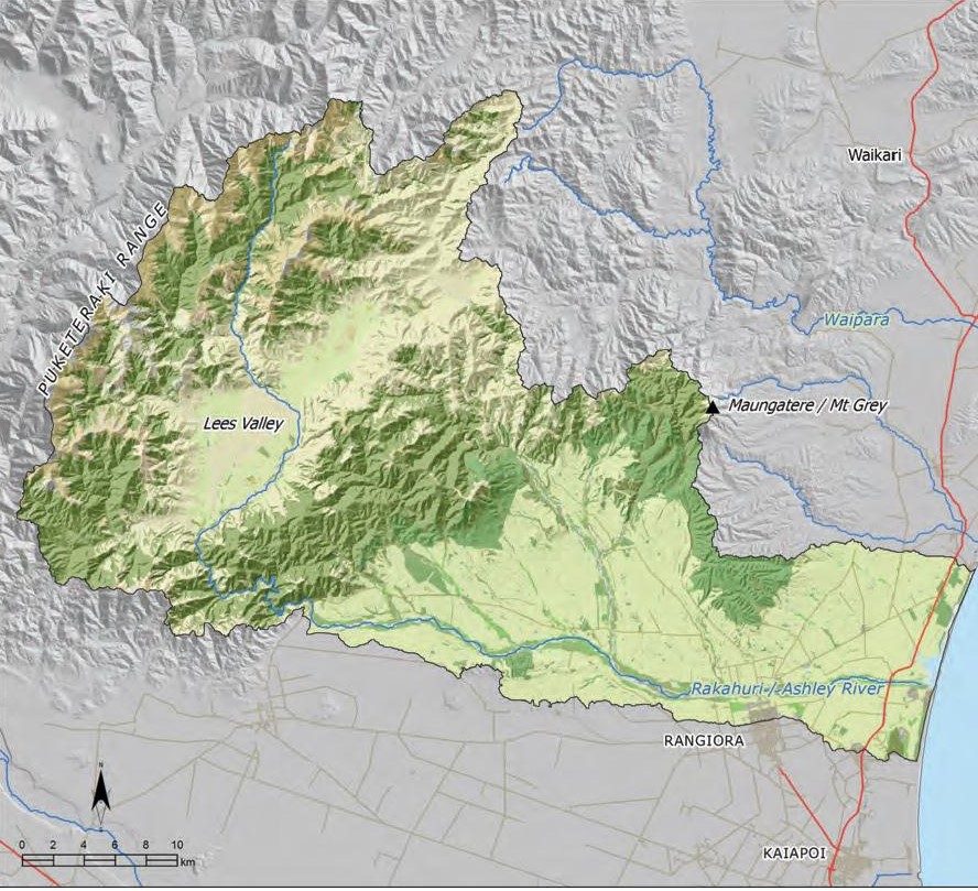
This section addresses issues of particular significance in Rakahuri River catchment (Map 9). Originating in the native forested hills of the Puketeraki Range, the hill fed Rakahuri winds through a narrow gorge before braiding across the North Canterbury plains and flowing into an extensive estuarine area.

The Rakahuri estuary is a significant feature of the catchment, and is a wāhi taonga for tāngata whenua. The estuary is part of a wider network of coastal wetlands and swamps between the Rakahuri and the Waimakariri rivers that have long been a source of mahinga kai for Ngāi Tahu.

The catchment has strong mahinga kai associations for Ngāi Tahu. The river and its associated tributaries, wetland and lagoons were known as the food basket of Kaiapoi pā. The Rakahuri was one of the three waterways (the others being Waimakariri and Ruataniwha/Cam) that continued to sustain Ngāi Tahu even after the land purchases in Canterbury.

From the late 1800s the Rakahuri has been managed with an emphasis on flood control and land preservation rather than mauri or mahinga kai. The substantial physical modification of the river and its tributaries has had significant effects on the relationship of Ngāi Tahu and their culture and traditions with this ancestral river.

"Ahi ka is about being brought up on the river and our continuous use over seven generations. It is about the river being more precious to us then any possession we may have. It is very hard to explain - it is how we live, it is what we know, it is what we have been taught. The Rakahuri is part of who we are."

"My poua didn’t have a whole lot of material things to leave us. But he had the river, and the river would always provide kai for us. The river was our inheritance; better than money in the bank, because it would always be there. Our poua left us the river, and the knowledge of the river."

Map 9: Rakahui catchment

NOTE: See Section 5.1 (Issue K1 - Recognising Manawhenua) for guidance on identifying the Papatipu Rūnanga with manawhenua and kaitiaki interests in this area.

Ngā Paetae | Objectives

(1) Restoration of the cultural health and mahinga kai values of the Rakahuri to a level and state whereby manawhenua can once again provide manuhiri with local kai that the river is known for.
(2) Water quality and quantity in the Rakahuri and tributaries is such that whānau and the wider community have places they can go to safely swim and fish.
(3) The coastal/lowland region from the Rakahuri to the Waimakariri is recognised and provided for as a cultural landscape of immense importance, and the cultural and physical connectivity between the Rakahuri, Taranaki stream, Tūtaepatu lagoon, Taerutu lagoon, Kaiapoi pā and the Waimakariri River is restored.
(4) The cultural health of the Taranaki stream is restored as a matter of priority, with a vision to return the waterway to its original shape and swampy character.
(5) Access to and use of customary fishing sites associated with the Rakahuri is restored.
(6) Provision of opportunities to instill traditional values in our young people through involvement in restoration projects and customary mahinga kai practices.

Ngā Take | Issues of Significance

R1: Customary Use

Issue R1: Loss and degradation of mahinga kai in the Rakahuri catchment as a result of:
(a) Physical modification of waterways for flood protection;
(b) Loss of flow;
(c) Sedimentation and gravel build up in the river;
(d) Drainage of mahinga kai wetland habitat;
(e) Loss or poor access to mahinga kai sites, including Fentons; and
(f) Inappropriate land use and development along the margins of waterways in the catchment.

Ngā Kaupapa / Policy

R1.1 To require that land and water management in the Rakahuri catchment recognises and provides for the importance of this river as mahinga kai to generations of Ngāi Tahu. This means that:
(a) The river should not be subject to the extremely low flows that it currently experiences (see Issue R2);
(b) The physical connection between the Rakahuri, Taranaki stream, Tūtaepatu, Taerutu and the Waimakariri River is restored, to enable fish passage;
(c) Inappropriate land use on floodplains and river margins is discontinued;
(d) Buffers and planted riparian margins along the river and tributaries to protect water quality;
(e) Flood protection infrastructure does not compromise fish passage;
(f) Access and use of customary fishing sites is recognised and provided for;
(g) The effects of upper catchment activities on mahinga kai in lower catchment areas are recognised and addressed;
(h) Kōhanga areas are protected; and
(i) Activities in the beds and margins of the river and its tributaries are consistent with protecting mahinga kai, including fish passage.

R1.2 To require that the regional council address the source of gravel and sediment that is accumulating in the river and resulting in the loss of mahinga kai habitat through reduced surface flow and infilling of the river mouth environment as a matter of priority. Sources of gravel and sediment include:
(a) Stop banks that confine the natural course of the river;
(b) Upper catchment erosion as a result of activities such as harvesting of plantation forestry trees; and
(c) Stock access to tributaries such as the Taranaki.

R1.3 To require that recreational use of the river is managed to avoid adverse effects on mahinga kai and Ngāi Tahu customary use.


Sustaining our mahinga kai traditions

R1.4 To investigate mahinga kai enhancement opportunities in the catchments, including restocking customary fish species.

R1.5 To continue to teach our tamariki and mokopuna about the Rakahuri River and associated waterways, springs, wetland and lagoons, and the mahinga kai traditions and pūrākau that are associated with those places.


Tributaries as mahinga kai

R1.6 To require improved tributary management in the catchment to restore mahinga kai habitat, with priority given to the following tributaries of ‘high use’ value:
(a) Taranaki Stream;
(b) Saltwater Creek;
(c) Waikuku Stream;
(d) Okuku River;
(e) Te Wera Wera (Little Ashley Stream);
(f) Harris’s Creek; and
(g) Smarts Road Creek;

R1.7 To require that the Taranaki stream is recognised and provided for as a kōhanga by:
(a) Re-naturalisation of the stream through establishment of riparian areas and restoration of the stream to original shape and levels;
(b) Redesigning the Taranaki floodgate as a matter of priority due to its impact on īnanga migration;
(c) Controls on land use on river margins and floodplain, including prohibiting intensive grazing, silage pits, offal pits, subdivision on the margins and the floodplain;
(d) Addressing stock access issues along the Taranaki between Waikuku Beach and Kaiapoi pā as a matter of priority;
(e) Fencing of the whole of the waterway; and
(f) Protection of the waipuna that feed Taranaki Creek and other spring-fed tributaries.

R1.8 To require that the upper reaches of the Okuku River are recognised and provided for as particularly important for tuna habitat.


Access for customary use

R1.9 To ensure that initiatives to protect the river mouth environment do not restrict the right of tāngata whenua to access the river mouth and mahinga kai resources.

R1.10 To require that the specific rights and interests associated with Fenton Reserves and other customary fishing sites are recognised and provided for including:
(a) Ensuring a continuous and reliable supply of water to these sites; and
(b) Unrestricted access.

He Kupu Whakamāhukihuki / Explanation

The Rakahuri catchment has experienced a significant loss of mahinga kai values. Drainage of wetlands, abstractions and the physical modification of waterways through stop banks, groynes, flood gates and channelisation have had significant effects on the physical and cultural connectivity of the river with its tributaries and coastal lagoons and wetlands. Today the river is managed for flood protection and land use, and unfortunately this has been at the expense of mauri and mahinga kai, and the ability of tāngata whenua to exercise cultural traditions such as Manaakitanga (See Box – Manaakitanga).

"Fentons were supposed to move with the water; this was the intent of the settlement. Water goes with the Fenton. You can’t have a Fenton without water."

Despite the significant loss and degradation of mahinga kai values, the importance of the river and its tributaries for mahinga kai has not diminished. Tāngata whenua are committed to restoring this wāhi taonga for future generations, and to teaching the tamariki and mokopuna about the river and associated waterways, springs, wetlands and lagoons, and the mahinga kai traditions associated with those places. The Taranaki stream is of particular importance. Restoring the river as mahinga kai requires a change of perspective - from controlling the river to working with the river; from drainage and infrastructure to wāhi taonga. Significant improvements in water quality and flow are required if the river is to sustain mahinga kai and customary use. This includes improved tributary management and the removal of impediments to fish passage. It also includes habitat enhancement and opportunities to restock customary fish species (tāngata whenua historically seeded pipi and cockles in the estuary.)(3)

"Our ideal is to have the Taranaki revert back to swamp. We realise that this is not possible to the extent we would like to see it. However, activities such as farming and subdivision on the Taranaki floodplain should not have priority. This waterway is a kōhanga for inanga. Mahinga kai values should not be the bottom of the list. We understand the need for flood protection, but in the middle of summer the floodgates on the Taranaki should not be closed."

"Before and after the whitebait season you can hear the eels [that have come from the Rakahuri] having a big feed on all the inanga that get caught at the closed floodgates."

Manaakitanga

The loss of cultural health and mahinga kai values in the Rakahuri has an affect on our ability to manaaki visitors to our marae. It is an affirmation of our mana to be able to feed manuhiri the local kai that our river is known for. This is gone for us; we now have to go to the supermarket. We want to restore the mahinga kai values to the Rakahuri: the pātiki, herrings, tuna, cockles, tuatua and pipi. We want to restore the river to a state where we can once again manaaki our visitors with local kai.

Source: Kōrero with Clare Williams and Joan Burgman, Ngāi Tūāhuriri Rūnanga, 2012

Fenton Reserves and Entitlements

In 1868, Judge Fenton made an order for water flow to be maintained to four native reserves in the Kaiapoi area: Taerutu, Waimaiaia, Torotora, and Te Aka Aka. Known as the Fenton Reserves, these areas were essentially fishing easements awarded in accordance with Kemp’s Deed to ensure on-going access by the beneficial owners to the associated waterways and their mahinga kai.

As part of the Ngāi Tahu Ancillary Claims settlement, Fenton entitlements were created to provide the Fenton reserve owners the opportunity to occupy land close to waterways in order to facilitate access to them for the lawful fishing and gathering of other natural resources. While the right to occupy is temporary (up to 210 days per year), the associated right to fish in part of the adjacent waterway is exclusive.

CASE STUDY: Te Aka Aka

Te Aka Aka was the name of an island located in the Rakahuri estuary, used as outpost mahinga kai and tauranga waka of the Kaiapoi pā. The island was reserved as a fishing easement by the Native Land Court in 1868. Today the reserve is landlocked as a result of land reclamation and river management; cut off from the estuary by the stop banks constructed
on the Rakahuri.

In the Ngāi Tahu Ancillary Claims Report (1991), the Waitangi Tribunal acknowledged that the fishing easements awarded in North Canterbury had been detrimentally affected by drainage as early as 1876. Specific reference was given to the Te Aka Aka fishing easement, which was deemed by the Tribunal as “useless for the purposes for which it was set aside”
(section 2.2)

Sources: Te Marino Lenihan, personal communication; Te Whakatau Kaupapa 1990; Ngāi Tahu Ancillary Claims Report 1995; Ashley River/Rakahuri River Catchment Tāngata Whenua Values Report 2003).

Cross reference:

» General policies on Wai Māori (Section 5.3)
» General policy on Mahinga kai (Section 5.5, Issue TM1)

R2: Water Quantity

Issue R2: The river experiences extremely low flows as a result of the cumulative effects of water abstractions, gravel build up and flood control infrastructure, and there is a lack of understanding about water recruitment into springs that are the source of the Rakahuri tributaries.

Ngā Kaupapa / Policy

R2.1 To require that environmental flow and water allocation limits for the Rakahuri and its tributaries are consistent with tāngata whenua values associated with the river, and therefore deliver the cultural outcomes set out in the general policy on flows and allocation limits (Section 5.3, Issue WM8), with particular focus on:
(a) Acknowledging the need to restore the cultural health of the river, not merely maintain its existing condition;
(b) Avoiding sediment build up and infilling of river mouth;
(c) Improving water quality; and
(d) Ensuring a continuous and quality water supply to customary fishing reserves associated with the Rakahuri.

R2.2 To require investigations into the relationship between groundwater and surface water in the catchment, with emphasis on the effects that groundwater abstractions are having on river levels and flows.

R2.3 To require that gravel build up in the riverbed is addressed by:
(a) Managing gravel extraction alongside and flow management;
(b) Extraction of gravel from the riverbed; and
(c) Addressing the sources of gravels building up in the riverbed.

He Kupu Whakamāhukihuki / Explanation

The Rakahuri currently experiences extremely low flows, particularly in summer. Local observations conclude that the loss of flow over the last 40 years is a result of the cumulative effects of water abstractions, gravel and sediment build up, and stop bank construction (see Box - Local observations of changes to the Rakahuri), and that the length of the time that particular areas of the river are dry is increasing.

Low flows affect mahinga kai and the ability to access mahinga kai. Customary fishing sites such as Te Aka Aka have been dewatered. Some reaches of the Rakahuri go dry in the summer, and this impedes the migration of tuna and other native fish. While tāngata whenua will continue to undertake fish salvaging operations, there is an urgent need to address why such operations are necessary (i.e. are these operations necessary because the river is over-allocated?).

"I have lived by the river for 46 years and over the last 10 years the rivers have become dry and stagnant. The long finned tuna, which are threatened, have been trying to migrate up and down the river but they end up in river pools and are literally cooked. The community have had to transport tuna to the coast."

"We cannot continue to take the amount of water we are currently taking out of this river without serious effects on the river."

The Rakahuri must be allowed to flow Ki Uta Ki Tai. The undisturbed passage of water from source to sea is not only necessary to sustain the wairua and the mauri of the river, but also to enable fish migration and to allow for the natural occurrence of freshes and floods and the movement of sediment down the river and out into the coastal environment. The relationship between groundwater and surface water needs to be better understood in the catchment, and reflected in the river’s environmental flow and allocation regime.

Local observations of changes to the Rakahuri over time

Flow and water levels

“Today you can walk across the Ashley River almost all year round within 1 kilometre from the estuary mouth, with the exception of when the river is in flood. To cross the Ashley River within 1 kilometre from the estuary 40 years ago a row boat was required, and this was during periods of drought.”

“Three metre Neap or spring tides used to reach the SH 1 road bridge 40 years ago. Today because of river management, the spring or neap tides do not go more than ½ the distance it used to travel up the river.”

“Whitebaiting at the mouth of the river was only available for about 1 hour after the tide turned and came up the river. After 1 hour if you remained fishing at the mouth, the waves would knock you over. This was no more than 30 years ago. Today you whitebait at the estuary for 4 hours after high tide.”


Sedimentation and gravel build up


“When groynes were built along the stop banks of the Ashley River, deep water always flowed beside them.
After many years the banks gathered shingle and sediment and the river flows began to disappear under the piles of shingle. The last 30 years has resulted in more islands of shingle and gravel slowly growing higher between the walls of the stop banks, and less water observed.”


“The shingle build up between the stop banks within the area east of SH 1 has created islands of shingle and sediment up to 6-8 feet above the water flow. These islands of sediment to the naked eye appear higher than the land level both to the north and south of the stopbanks…shingle has been piling up in the estuary and backing up west of the river. The greatest effect on the value of the river is the piling up of shingle within the riverbed.”

Degradation of mahinga kai

“Spearing of eels is now reduced substantially from previously abundant stocks. 50 years ago, 50 eels could be taken in an hour. Today, it would take twice as long to spear 5 eels, if you are lucky.”

“A net set for flounders within the estuary of the Ashley 30 years ago would net on average 40-80 flounders. The catch today would be 10 – 15 if the fisher was lucky.”


Tributaries

“Tributaries such as the Taranaki and Little Ashley have been modified by drainage, removal of associated wetlands, filling up with sediment, and very little can be seen of shingle bottoms within these tributaries. They are becoming weed infested tributaries.”

As documented by tāngata whenua in: Tau, H. R. 2003, Ashley River/Rakahuri River Catchment Tāngata Whenua Values Report. Environment Canterbury Report.

Cross reference:

» General policies in Section 5.3 – Issue WM6: Water quality, and Issue WM8: Water quantity

R3: Wetlands and Hāpua

Issue R3: The restoration of wetlands and hāpua in the Rakahuri catchment.

Ngā Kaupapa / Policy

R3.1 To highlight the importance of wetland and swamp areas in the Rakahuri catchment to Ngāi Tahu for mahinga kai and wāhi tapu values.

R3.2 To prohibit any further drainage of existing wetlands.

R3.3 To require the restoration of wetlands in the catchment as a priority, as a means of restoring cultural health and connectivity to the catchment.

R3.4 To continue to promote the role of wetlands as natural flood protection and critical mahinga kai habitat.

R3.5 To continue to support Te Kohaka o Tuhaitara Trust and the restoration of Tūtaepatu Lagoon as a matter of priority, with emphasis on:
(a) Weed control;
(b) Fencing;
(c) Planting of native species; and
(d) Providing opportunities for tāngata whenua to regain cultural associations, including mahinga kai, with this important place. This may include the development of regulations prohibiting commercial fishing.

R3.6 To advocate for the restoration of the flow and character of Taerutu stream and lagoon as a wetland of historical and cultural significance.

He Kupu Whakamāhukihuki / Explanation

Wetland and swamp areas in the Rakahuri catchment are highly significant to Ngāi Tahu for mahinga kai and wāhi tapu values. The wetland system once fed by the Rakahuri was one of the reasons why Māori settled in the area, and the wetland system became the centre of community life (4). Today, the vast majority of wetlands have been lost or substantially modified to make way for settlement and farming.

Tūtaepatu Lagoon is a wetland of immense cultural importance known for mahinga kai, kāinga nohanga and urupā values. Ownership of Tūtaepatu was transferred to Ngāi Tahu as part of the Ngāi Tahu Settlement in 1998. The site is now managed by Te Kohaka o Tuhaitara Trust and a restoration programme is in progress. The lagoon area lies within Silent file 013 (See Appendix 6 for a Schedule of silent file maps). Ngāi Tahu used the lagoon for eel fishing until the 1970s, when drainage of the area together with farm run-off led to the decline of the fishery (5).

Taerutu is a lagoon/swamp area next to Kaiapoi pā, once providing canoe access to the pā. Historically a rich source of mahinga kai, the site is also recognised as a wāhi tapu and urupā. Taerutu is one of five fishing easements awarded to Ngāi Tahu in the vicinity of Kaiapoi pā. Today, the remnant lagoon is vested in trustees nominated by Ngāi Tūāhuriri Rūnanga (Maori Reserve 898, Block vii, Rangiora SD).

"It would be ideal to have water at Taerutu. Water can protect this site and associated cultural values such as wāhi tapu from development."

"The Taranaki Creek drains the Tairutu Lagoon at Old Kaiapohia and Houhou-pounamu is the deep part of the Lagoon." (6)

R4: Water Quality

Issue R4: Water quality in the catchment is at risk as a result of:
(a) Stock access to waterways;
(b) Unconsented discharges;
(c) Inappropriate land use on waterway margins and floodplains;
(d) Poor or no riparian margins on waterways;
(e) Forestry activities in the upper catchment;
(f) Drainage of wetlands; and
(g) Run-off from farm land.

Ngā Kaupapa / Policy

R4.1 To require improved tributary management as a means to improve water quality in the Rakahuri, including but not limited to:
(a) Review of flow and allocation regimes;
(b) Elimination of discharges of contaminants from agricultural, pastoral and settlement based land use;
(c) Prohibiting stock access to waterways and wetlands, and areas that were once and should be waterways and wetlands (e.g. ephemeral streams, drained wetland);
(d) Implementing a programme for eliminating invasive species;
(e) Prohibiting the further clearance of indigenous vegetation;
(f) Protection of waipuna from inappropriate use and degradation; and
(g) Establishment of indigenous planted riparian areas to provide stability and buffers against the effects of land use.

R4.2 To require effective controls on upper catchment land use to address sedimentation in the lower catchment.

R4.3 To require the monitoring of water quality at the Rakahuri river mouth and estuary as a means to monitor the health of the catchment.

He Kupu Whakamāhukihuki / Explanation

Water quality in the Rakahuri tributaries is critical to sustaining the mauri of the river. Poor water quality and low flows in tributaries contribute to an overall cumulative effect on the river, particularly in the lower reaches and the estuary. Of particular importance is water quality monitoring at the Rakahuri river mouth. The high significance of the area and the well-recognised value of hāpua and river mouth environments as monitoring sites (see Section 5.6 Issue TAN3) makes the estuarine zone a monitoring priority.

"Ngāi Tahu priorities for the protection of flows in lesser streams and creeks are not always reflected in other sectors of the community. For example, despite its significance to tāngata whenua for food gathering, Taranaki Creek has been described as ‘of little interest’ for ‘water resources assessment purposes." (7)

Cross reference:

» Issue R1: Customary use
» General policy on water quality (Section 5.3 Issue WM6)

R5: Cultural Landscape Values

Issue R5: Inappropriate land use and development can have effects on wāhi tapu and wāhi taonga values in the catchment, and the association of tāngata whenua with these places.

Ngā Kaupapa / Policy

R5.1To recognise and provide for the area between the Rakahuri and Waimakariri as a cultural landscape with significant historical, traditional, cultural and contemporary associations. This includes:
(a) Rakahuri estuary;
(b) Saltwater creek;
(c) Taranaki stream;
(d) Taerutu stream and lagoon;
(e) Tūtaepatu lagoon;
(f) Kaiapoi pā;
(g) Waimakariri River; and
(h) The physical and cultural connections between these places.

R5.2 To work as an iwi to investigate and discuss options for improving management of the Kaiapoi pā site, consistent with the status of the site as a wāhi tapu.

R5.3 To apply to the New Zealand Geographical Board to change the name of Preeces Road to Kaiapoi pā Road.

R5.4 To utilise the methods in general policies on Wāhi tapu me wāhi taonga and Silent files (Section 5.8, Issue CL3 and CL4) to protect wāhi tapu and wāhi taonga from land use, subdivision and development activity in the catchment.

He Kupu Whakamāhukihuki / Explanation

The Rakahuri River is recognised as a cultural landscape given the numerous mahinga kai, wāhi tapu and wāhi taonga values associated with the catchment. Two silent files are located in the catchment - 017 and 014. Silent file 011 extends into the southern part of the catchment, highlighting the important cultural and physical connections between the Rakahuri and Kaiapoi pā. Silent files, wāhi tapu and wāhi taonga are predominately located in and around historic wetland areas (now drained), and along waterways (see Appendix 7 for silent file maps).

"When we walked away from areas like Ōnawe, Takapūneke and Kaiapoi, it didn’t mean we left it for someone else to live there. It was because of the tapu.  It was not that we didn’t want it.  We had put a sacred wāhi tapu so no-one else would go there. The intent was that these sites would remain with us forever."

"The whole of the Ashley/Rakahuri and its surrounding network of tributaries and wetlands is a site of historic significance to the tāngata whenua who hold customary authority to this area. It has been an important settlement, food gathering and tupuna (ancestral) heritage area over hundreds of years of occupation of the land." (8)

Kaiapoi pā

“The decision to leave Kai-a-poi pā was no doubt founded on both respect for those who had died at the hands of Te Rauparaha, and in deference to the extremely tapu nature that now prevailed over this site as a consequence of that bloodshed. Indeed, the ostensible abandonment of Kai-poi pā should not be seen as a sign of neglect or disregard of this highly significant site (as some may be tempted to conclude), but simply as tikanga Māori of that time.

Right now, we have an opportunity to reconsider our relationship with this site and decide together how we might want to recognise and celebrate our collective history not only for the benefit of our tamariki and mokopuna, but also for those that now live amongst us or who visit our shores who may otherwise never have the opportunity to learn about our unique history with this land and hence begin to understand us better… The opportunity now presents itself [however] to come together and decide what it is we want, and begin to discuss how we wish to get there.”

Source: Lenihan, TM. (2005). Pegasus Stormwater Cultural Impact Assessment Report

R6: Upper Catchment

Issue R6: Protection of the integrity and natural character of the upper catchment from effects associated with:
(a) Land use conversion;
(b) Drainage of wetlands; and
(c) Water enhancement and irrigation proposals.

Ngā Kaupapa / Policy

6.1 To require that the tributaries in the upper reaches of the Rakahuri are recognised and protected as significant for their relatively high water quality and the contribution that they make to the mainstem, as a first order priority.

R6.2 To assess any proposals for water storage and irrigation in the Rakahuri catchment with reference to general policy on regional water infrastructure proposals (Section 5.3 Issue WM9), and also:
(a) A cultural bottom line of no further impacts on water quality and quantity in the Rakahuri. The only effects of the river should be enhancement opportunities to restore the mauri of our river;
(b) Protection of Rakahuri gorge as a significant cultural landscape;
(c) Potential for mixing of waters; and
(d) The potential benefits to water quality and quantity in the Rakahuri mainstem.

R6.3 To require controls on the extent of plantation forestry in the upper catchment, reflecting the water sensitive nature of the catchment.

R6.4 To avoid the drainage of wetlands in the catchment above the Rakahuri Gorge.

R6.5 To avoid increases in trout populations in the upper catchment, as trout are a threat to inanga populations.

R6.6 To recognise and provide for the upper reaches of the Okuku River as tuna habitat as a first order priority.

He Kupu Whakamāhukihuki / Explanation

Tributaries in the higher reaches of the Rakahuri are significant for their relatively high water quality and the contribution that they make to the mainstem. They retain high natural character values with many providing important mahinga kai habitats. There is a close relationship between land use in the upper catchment and the water quality and quantity in lower catchment areas. The effects of upper catchment land use and erosion are evident in the lower reaches of the Rakahuri: gravel and sediment is accumulating in the riverbed and contributing to infilling of the river mouth area. This has significant effects on mahinga kai habitat (Issue R1) and flow volume and character (Issue R2).

END NOTES / REFERENCES

  1. Tau, H.R., 2003. Ashley River/Rakahuri River Catchment Tangata Whenua Values Report. Environment Canterbury Report No. U03/54, p. 9.

  2. Waitangi Tribunal, 1991. Ngāi Tahu Land Report 1991, chapter 17, paragraph 17.2.4.

  3. Tau, H.R., 2003. Ashley River/Rakahuri River Catchment Tangata Whenua Values Report. Environment Canterbury Report No. U03/54, p.

  4. Ibid.

  5. Waitangi Tribunal, 1991. Ngāi Tahu Land Report 1991, paragraph 2.9.1.

  6. Taylor, W. A., 1952. Lore and History of the South Island Māori. Bascands, Christchurch, NZ, 1952.

  7. Tau, H.R., 2003. Ashley River/Rakahuri River Catchment Tangata Whenua Values Report. Environment Canterbury Report No. U03/54.

  8. Ibid, p. 11.