IMP: Ngā Take ā-hikawai Me Ngā Kaupapa | Catchments

6.12 Rakaia ki Hakatere

Wāhi Tuaono | Part 6

6.12 Rakaia to Hakatere [RH]

Rakaia river

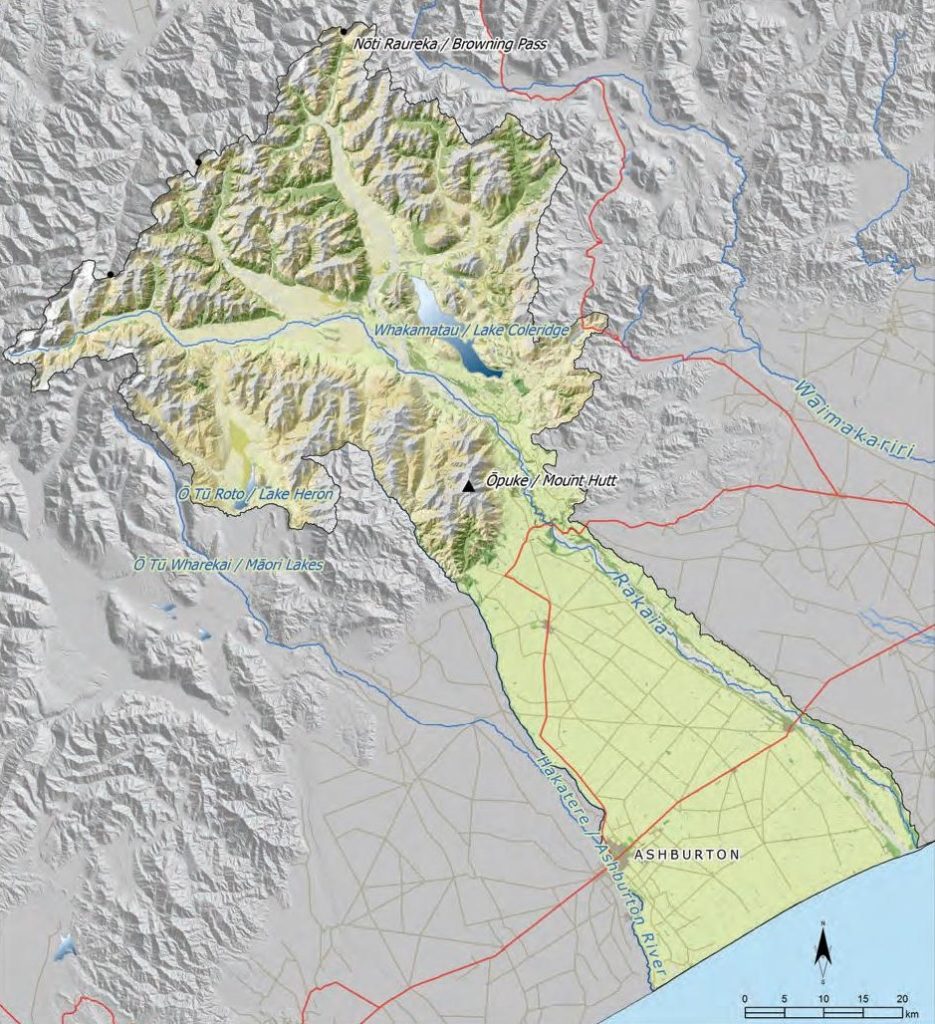
This section addresses issues of particular significance from
the Rakaia River to the Hakatere River (Map 24). The section covers all of the Rakaia catchment, and the land between the Rakaia and the Hakatere rivers. The Hakatere is the southern boundary of the takiwā covered by this IMP.

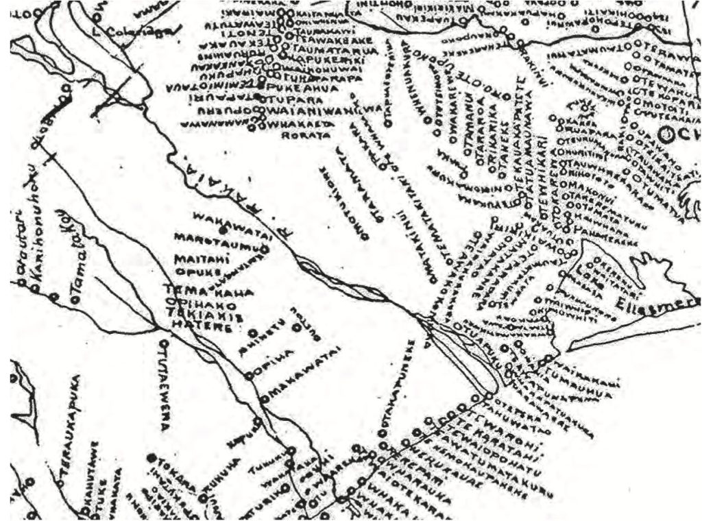
A Statutory Acknowledgement and Deed of Recognition
under the NTCSA 1998 formally acknowledge the
associations of Ngāi Tahu with the Hakatere, particularly
with regard to mahinga kai. The name of the river was
officially amended to a dual place name under the Act ,
serving as a tangible reminder of Ngāi Tahu history in
Te Waipounamu.

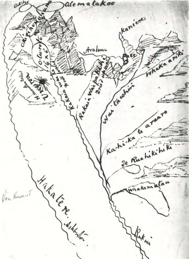
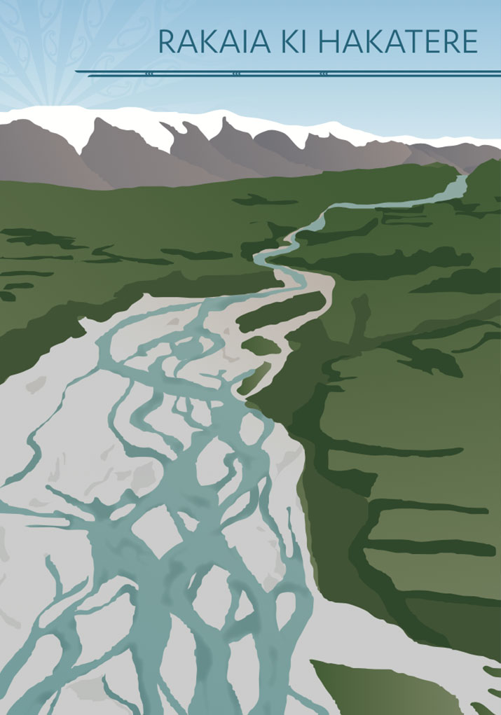
The Rakaia is one of the major braided rivers of the takiwā.
Throughout its course from the mountains to the sea, the
Rakaia exhibits a diversity of character, reflected in the
different landscapes through which the river flows. For
Ngāi Tahu, the variable character of the river is essential
to its cultural value, and is reflective of its life force.

The majority of the Rakaia River catchment is upstream
of the Rakaia Gorge, and therefore the protection of high
country values is an important kaupapa in this section.
Over-allocation of groundwater resources and contamination of both surface and groundwater are also significant issues, as the plains and coastal region between the Rakaia and Hakatere rivers is dominated by intensive land use.

Map 24: Rakaia to the Hakatere

Map 24 Rakaia and Hakatere catchment

NOTE: See Section 5.1 (Issue K1 - Recognising Manawhenua) for guidance on identifying the Papatipu Rūnanga with manawhenua and kaitiaki interests in this area.

Ngā Paetae | Objectives

(1) The mauri and mahinga kai values of the Hakatere and Rakaia Rivers and their tributaries, lakes and wetlands and hāpua are protected and restored, mō tātou, ā, mō kā uri ā muri ake nei.
(2) Management of the Rakaia River, including the Rakaia Water Conservation Order (RWCO), recognises and provides for outstanding cultural characteristics of the catchment and therefore improved protection for this ancestral river.
(3) Immediate and effective measures are implemented to address over-allocation of freshwater resources in the region from the Rakaia to the Hakatere River.
(4) Groundwater and surface water quality in the catchments is restored to a level suitable to provide a safe, reliable and untreated drinking water supply and enable cultural, customary and recreational use.
(5) Land use in the catchments reflects land capability and water limits, boundaries and availability.
(6) Ngāi Tahu cultural landscapes and cultural landscape values associated are protected and enhanced.

Ngā Take | Issues of Significance

RH1: Shared Interest

Issue RH1: The Hakatere and Rakaia rivers as areas of shared interest.

Ngā Kaupapa / Policy

RH1.1 To recognise and provide for the Hakatere and Rakaia rivers as areas of shared interest and responsibility with Te Rūnanga o Arowhenua.

He Kupu Whakamāhukihuki / Explanation

The Hakatere is the southern boundary of the takiwā covered by this IMP. The Hakatere and Rakaia Rivers are areas of shared interest with Te Rūnanga o Arowhenua, as per the takiwā boundaries set out in the Te Rūnanga o Ngāi Tahu (Declaration of Membership) Order 2001.

RH2: Rakaia River

Issue RH2: Protecting the outstanding cultural characteristics associated with the Rakaia River.

Ngā Kaupapa / Policy

RH2.1 To require that the Rakaia River catchment is recognised as possessing outstanding cultural characteristics and values, including but not limited to:
(a) Mahinga kai, including nohoanga;
(b) Ara tawhito ki pounamu;
(c) Natural character of a braided river, including natural processes;
(d) Wāhi tapu and wāhi taonga;
(e) Whakamatau;
(f) Ō Tū Roto;
(g) Waitawhiri;
(h) River mouth and the hāpua; and
(i) The Rakaia and Whakamatau as Statutory Acknowledgement sites.


Water Conservation Order

RH2.2 To require a review and amendment of the National Water Conservation (Rakaia River) Order 1988 to recognise and protect the outstanding cultural characteristics and values as per RH2.1, and the water quality and quantity to sustain those characteristics and values.

RH2.3 To require that the outstanding cultural characteristics of the Rakaia River catchment are protected by setting limits and controls to ensure:
(a) The flow of water Ki Uta Ki Tai: between the river, lakes, tributaries, hāpua and the sea;
(b) No further reduction in average flows in the river, and no further increase in the frequency or duration of low flows, particularly at the river mouth;
(c) The priority for water from Whakamatau is for the Rakaia River, to protect and maintain mauri and mahinga kai and hāpua values; and
(d) Sufficient flow to deliver the cultural outcomes set out in general policy on Water quantity (Section 5.3 Issue WM8) in particular:
(i) Maintain continuous opening of the river mouth to the sea;
(ii) Support mahinga kai and its restoration to its former diversity and abundance;
(iii) Enable cultural use, including the use of nohoanga;
(iv) Enabling the river to carry larger gravels and sediments that are necessary to sustain coastal processes;
(v) Protect and enhance qualities and character of the braided river; and
(vi) Provide security of aquifer recharge in the catchment, including protection of the relationship of the Rakaia and groundwater recharge in the lower Te Waihora catchment.


Mahinga kai

RH2.4 To oppose any proposal to take, use, dam or divert water in the Rakaia catchment that will compromise Ngāi Tahu efforts to restore mahinga kai resources and practices in the catchment.

RH2.5 To highlight two issues as of particular importance to resolve with regard to mahinga kai in the Rakaia catchment:
(a) Ensuring fish passage at the hāpua; and
(b) The recruitment and escapement of long fin eel in Whakamatau.

RH2.6 To continue to support and build the capacity of the Whakamatau (Lake Coleridge) Eel Management Trust, as a means to progressing ways to enhance the populations of long fin eel within the lake and assisting them to complete their life cycle within the Rakaia/Whakamatau catchment.

RH2.7 To work with Te Rūnanga o Ngāi Tahu to review the Nohoanga entitlements on the Rakaia River with attention to:
(a) Investigating any barriers to use (physical or otherwise);
(b) Measures to enable and encourage whānau to use nohoanga; and
(c) Use of nohoanga as part of restoring the relationship of Ngāi Tahu to the Rakaia.


Research

RH2.8 To work with the regional council to address unresolved questions about the hydrology of the Rakaia River, in particular: (a) How and why are flows at the Rakaia River mouth diminished when flows remain moderate at the Gorge?


River bed and margin

RH2.9 To advocate for riparian margins on both sides of the Rakaia River that are the same width as the river itself, to enable the river to spread in times of flooding, and preserve the character of the braided river.

RH2.10 To require the identification and control of upper catchment sources of woody weeds such as gorse and broom that are infesting lower catchment braids.

He Kupu Whakamāhukihuki / Explanation

The Rakaia River possesses a range of characteristics that are considered to be outstanding for spiritual, cultural and environmental reasons and fundamental to the relationship of Ngāi Tahu to the Rakaia River. Mahinga kai is one of the most important of these, as the catchment once provided an abundant source of mahinga kai resources (see Map 25 - 1880 Taiaroa Mahinga Kai Map). The river was also an important trail to Te Tai Poutini (Map 26).

Ngāi Tahu is actively seeking to restore mahinga kai values in the catchment, and the traditions associated with those values. Increasing pressure on the land and water resources of the catchment, including from water enhancement and hydrogeneration schemes, creates challenges to achieving these aspirations. For example, there appears to be little recruitment of tuna to Whakamatau since the implementation of the Wilberforce Diversion, and no opportunity for tuna to leave the lake and return to the sea for spawning.

"As eels are a very long-lived species, it is possible that extensive decline in the eel stocks in the Lake [Whakamatau] is yet to become apparent or is only just starting to do so." (2)

Increasing pressure on water resources is evident in observed changes to the hāpua at the river mouth. Low flows in the river are having visible impacts on the integrity, form and resilience of the hāpua and therefore on mahinga kai values. The river is close to being fully allocated, but some allocated water has yet to be taken up, so the full impact of reduced flows at the mouth may not yet be apparent. (3)

"Flooding at the river mouth is not due to too much water in the river. Flooding is actually a result of not enough flow, particularly when a moderate flood follows a period of low flows. When there is insufficient water in the Rakaia to keep the river mouth open, it blocks and then water comes up on to land and the lagoon, and the nohoanga gets flooded."

The Rakaia River is protected by the National Water Conservation (Rakaia River) Order 1988 (RRWCO). The order is designed to preserve and protect the outstanding characteristics and features of the Rakaia and its tributaries, and includes various restrictions on the take, use, damming, diversion and discharge of water within the catchment. Ngāi Tahu did not have the opportunity or capacity to contribute to the RRWCO when it was granted, and therefore the Order has no provision for safeguarding Ngāi Tahu cultural values associated with the catchment, including mahinga kai. Further, there is concern that the Order is not achieving its existing objectives:

"Ngāi Tahu do not believe the Rakaia WCO is achieving the current objective to preserve and protect the outstanding characteristics and features that exist within the Rakaia River catchment. In particular the hāpua has undergone significant changes over the past 5 years. "

The RRWCO needs to align with existing RMA and Ngāi Tahu Settlement provisions, including the ability of a water conservation order to protect those characteristics which are considered to be of outstanding significance in accordance with tikanga Māori (RMA section 199 (2) c)). Water conservation orders are effective tools for protecting freshwater resources; but like any other tool they need to be reviewed over time.

"You can’t just put a WCO on a river and then walk away. "

Map 25: Extract from the Taiaroa 1880 Mahinga Kai Maps, showing mahinga kai sites in the Rakaia and Te Waihora catchments. During the 1879 Royal Commission on the Ngāi Tahu Land Claims, Hori Kerei Taiaroa from Ōtākou gathered information from Ngāi Tahu kaumātua about their traditional food gathering sites. and the foods gathered at these sites The information collected by Taiaroa provides some of the earliest records from Ngāi Tahu kaumātua on mahinga kai sites in the 1840s.

Map 25 Extract from the Taiaroa 1880 Mahinga Kai Maps, showing mahinga kai sites in the Rakaia and Te Waihora catchment

Map 26: One of the earliest maps of the Rakaia catchment, drawn by Julius Von Haast ca 1860. The key Ngāi Tahu features of the map are: Waitawhiri is the Wilberforce River; Whakaariki is a tributary of the Waitawhiri; Rakaia-wai-pakihi is the name for the Mathias River; Rakaia-wai-ki is the southern branch of the Rakaia River; Ō Tū Roto is Lake Heron; Kirihonuhonu is Lake Emma; Hakatere is the Ashburton River and Noti Raureka is the name for Brownings Pass.

Map 26: One of the earliest maps of the Rakaia catchment, drawn by Julius Von Haast ca 1860

Cross reference:


» General policies on Wai Māori (Section 5.3) Information resource
» Norton, T., 2012. Rakaia ki Whakamatau. Ngāi Tahu cultural association with the Rakaia River and Whakamatau (Lake Coleridge). Te Rūnanga o Ngāi Tahu.

RH3: Hakatere

Issue RH3: The mauri and mahinga kai values of the Hakatere continue to be degraded as a result of:
(a) Poor water quality;
(b) Low (and no) flows and a highly modified flow regime; and
(c) Over-allocation of river water.

Ngā Kaupapa / Policy

RH3.1 To require that water quality is a paramount determinant governing land and water use and development in the Hakatere catchment, as per general policy on Water quality (Section 5.3 Issue WM6), and that the restoration of mauri and water quality is addressed as a matter of priority.


Over-allocation of surface water

RH3.2 To require immediate and effective steps for addressing over-allocation, with reference to general policy on Water quantity (Section 5.3 Issue WM8), as well as:
(a) Avoid consenting any takes for hydraulically connected groundwater, regardless of the allocation status of the groundwater zone.

RH3.3 To require that environmental flow and water allocation regimes for the Hakatere deliver cultural outcomes, as per general policy on Water quantity (Section 5.3 Issue WM8), with particular emphasis on ensuring:
(a) The flow regime restores the natural flow character and variability, and therefore mauri, of the river; and
(b) There is sufficient flow to:
(i) Keep the river mouth open;
(ii) Restore flows to those tributaries that are dry;
(iii) Maintain the braided character; and
(iv) Enable both the north and south branches to flow continuously over their full length, Ki Uta Ki Tai.

He Kupu Whakamāhukihuki / Explanation

The Hakatere has suffered low flows and poor water quality for years. Tāngata whenua assessments identify the Hakatere, Rakahuri and Waikirikiri as similar types of rivers that are all facing the same issues, and the Hakatere is assessed as in the worst state of cultural health of the three. Abstractions from the river for irrigation and for stock water (i.e. stock water races) are seriously compromising the mauri of this river. Over-allocation has resulted in a highly modified flow regime; including prolonged periods of low or no flows in some tributaries.

RH4: Water Quality in Lowland Streams

Issue RH4: Poor water quality in lowland and coastal streams, and stock water races, as a result of point and non-point source pollution. ​

Ngā Kaupapa / Policy

RH4.1 To require that water quality is a paramount determinant governing land and water use and development from the Rakaia to the Hakatere, as per general policies on Water quality (Section 5.3 Issue WM6).

RH4.2 To require that stock water races in the catchment are managed as waterways. This means:
(a) Water in stock water races is accounted for in catchment assessments of water use;
(b) Stock access is prohibited;
(c) Appropriately sized buffers and riparian margins; and
(d) Native fish values are protected, including fish passage.

He Kupu Whakamāhukihuki / Explanation

The Rakaia River has relatively high water quality, as do the foothill streams. As with other catchments in the takiwā, water quality deteriorates as you travel down the catchment. Lowland streams and stock water races between the Rakaia and the Hakatere rivers are highly enriched with nutrients and faecal contamination, reflecting the effects of intensive land use and the lack of appropriate controls to protect waterways from point and non point source pollution. This has significant effects on the mauri, taonga, wāhi tapu, indigenous biodiversity and mahinga kai values associated with these waterways.

"Should there really be a dairy farm in the middle of a river? "

Stock water races are defined as an artificial watercourse used for the managed conveyance of water for stock water purposes. However, they also provide habitat for native fish and other biodiversity, contributing to the wider network of mahinga kai habitat in lowland streams and drains. Managing stock water races as waterways is consistent with Ngāi Tahu policies that require that drains are recognised as waterways for the purposes of water management.

Cross reference:

» General policies in Section 5.3 – Issue WM6: Water quality; and Issue WM7: Effects of intensive land use on water
» General policy on Papatūānuku (Section 5.4, Issue P1)

RH5: Groundwater

Issue RH5: Nitrate contamination and over-allocation of groundwater resources.

Ngā Kaupapa / Policy

Groundwater quality

RH5.1 To require effective controls to regulate discharge to land activities associated with intensive agriculture and industrial activities in the lower catchment, as per general policy on Water quality (Section 5.3, Issue WM6) and the Effects of land use on water resources (Section 5.3 Issue WM7), with particular attention to:
(a) The cumulative impact of agricultural land use activities in the area; and
(b) Diffuse pollution from industrial discharges (e.g. effluent disposal from meatworks).


Over-allocation

RH5.2 To work with local authorities and zone committees to improve our understanding of the groundwater resource in the Rakaia and Hakatere catchments, as a matter of priority.

RH5.3 To require immediate and effective measures and timeframes to address over-allocation, as per general policy on Water quantity (Section 5.3, Issue WM8), with particular attention to:
(a) Avoiding further land use conversion (for water intensive land use) until over-allocation addressed.

RH5.4 To require a rural land and water management approach that ‘matches land use with water availability, limits and boundaries’, consistent with general policy on Water quantity (Section 5.3 Issue WM8) and Papatūānuku (Section 5.4 Issue P1).

RH5.5 To require that the relationship between surface water and groundwater resources is recognised and provided for in the catchment. This means:
(a) Recognising the relationship between over allocation and contamination of groundwater resources;
(b) Ensuring that environmental flow and water allocation regimes provide sufficient water in waterways for aquifer recharge;
(c) Recognising the relationship between Rakaia River flow and groundwater recharge in the lower Te Waihora catchment; and
(d) Recognising the effects of groundwater abstractions on lowland stream flows.

He Kupu Whakamāhukihuki / Explanation

Groundwater under the lowland plains of the Rakaia and Hakatere catchments is at risk due to nitrate contamination and over-allocation.

"Of the 155 wells sampled in the three investigations (excluding consent monitoring data), groundwater samples from 39 wells (25%) had nitrate nitrogen concentrations above the MAV, and samples from 124 wells (80%) had nitrate nitrogen concentrations above half the MAV. These proportions are very high in comparison to the entire Canterbury region." (4)

Addressing non point source pollution is critical to resolving water quality issues in the Rakaia and Hakatere catchments, as with the takiwā as a whole. Inappropriate and unsustainable land use compromises the ability of Papatūānuku to absorb and filter nutrients and waste. Further, tāngata whenua firmly believe that the contamination of groundwater resources is directly related to the over-allocation of water. Over-allocation of groundwater ‘creates a space’ for contamination to occur.

"Maintaining the quality of the groundwater resource for future generations must have priority over intensive land use."

The demand for water for intensive land use, coupled with inadequate management frameworks have resulted in the over-allocation of groundwater in the takiwā, and the designation of red zones. Tāngata whenua maintain that this is reflective of a blatant disregard for the environment and future generations.
The answer to over-allocation is not to look at ways to find more water. While the sustainable storage of water has the potential to ease the pressure on groundwater resources, these measures do little to address the source of the problem. Tāngata whenua are still looking for answers to the hard questions: How did the catchment become over-allocated? How sustainable and efficient is the land use that our water resources are supporting?

RH6: High Country Lakes and Wetlands

Issue RH6: Recognising the cultural associations of Ngāi Tahu with high country lakes, tarns and wetlands.

Ngā Kaupapa / Policy

Cultural landscapes

RH6.1 To recognise and provide for Whakamatau, Ō Tu Roto and associated high country lakes and wetlands as cultural landscapes with significant historical, traditional, cultural and contemporary associations. Key characteristics of these cultural landscapes include:
(a) Mahinga kai traditions, species and habitat;
(b) High natural character;
(c) Iwi, hapū and whānau history; and
(d) Indigenous biodiversity.

RH6.2To require that the mana and intent of the Statutory Acknowledgement for Whakamatau (NTCSA 1998) is recognised and provided for beyond the expiry of the Ngāi Tahu Claims Settlement (Resource Management Consent Notification) Regulations 1999.

RH6.3 To require that the outstanding cultural characteristics of high country lakes in the Rakaia catchment, as described in regional planning documents, include cultural features - with specific reference to mahinga kai - in addition to wildlife habitat, fisheries and recreational features.

RH6.4 To recognise the relationship between Ō Tu Roto and the other lakes and wetlands that make up Ō Tū Wharekai (Ashburton Lakes), and to support ongoing restoration projects such as the Arawai Kakariki wetlands restoration programme.


Customary use

RH6.5 To investigate options to improve customary use opportunities associated with high country wetlands and lakes, including:
(a) Wānanga, to facilitate the intergenerational transfer of knowledge on traditional mahinga kai resources, sites and practices; and
(b) Access arrangements with landowners to sites of importance.


Effects of land use

RH6.6 To protect high country lakes and their margins from sedimentation by:
(a) Requiring the protection of riparian areas and lake edge wetlands;
(b) Prohibiting stock access to the lake;
(c) Prohibiting the discharge of contaminants to water;
(d) Prohibiting inappropriate discharge to land activities that result in run-off into lake margins, including fertiliser application; and
(e) Prohibiting forestry activity on lake and tributary margins.

He Kupu Whakamāhukihuki / Explanation

High country lakes are significant features of the relationship of Ngāi Tahu with the high country. Lakes were important sites on the high country trails, providing an abundance of food and other resources. Wetlands and tarns were also important features of this relationship.

High country lakes such as Whakamatau and Ō Tū Roto were used by Ngāi Tahu up until the middle part of the 19th century, with principal foods being tuna, pūtangitangi, parera, pāteke, whio, pukeko, kāuru, āruhe and weka.(5) In addition to mahinga kai resources, there are permanent settlement, camp sites and urupā associated with these lakes.

Whakamatau and Ō Tū Roto and Te Hāpua a Waikawa are the primary lakes in the Rakaia catchment. Smaller lakes and wetlands include lakes Catherine, Lillan, Ida, Evelyn, Henrietta, Selfe, and Georgina, all recognised in regional planning documents for their value as high naturalness waterbodies. Ō Tū Roto is one of the 12 lakes of Ō Tu Wharekai (Ashburton Lakes), and is one of the best examples of an inter-montaine wetland system remaining in New Zealand. It is one of three sites that make up the national Arawai Kakariki wetlands restoration programme. The area was a major part of seasonal mahinga kai gathering for Ngāi Tahu, as well as a site of permanent kāinga.

Through the NTCSA 1998, a Statutory Acknowledgement and Deed of Recognition formally acknowledges the immense cultural, traditional, historical and spiritual importance of Whakamatau to Ngāi Tahu (Schedule 76; See Appendix 7). The lake is referred to in the tradition of “Ngā Puna Wai Karikari o Rākaihautu”, which tells of how the principal lakes of Te Waipounamu were dug by the rangatira Rākaihautu using his famous kō or digging stick.

Cross reference:

» Issue RH8: Indigenous biodiversity
» Issue RH7: High country land use

RH7: High Country land Use

Issue RH7: Inappropriate high country land use can have adverse effects on cultural and ecological values including:
(a) Mauri of lakes, wetlands, and waterways;
(b) Indigenous biodiversity, including mahinga kai resources and sites;
(c) Ngāi Tahu access to mahinga kai sites or places of spiritual significance; and
(d) Wāhi tapu and wāhi taonga.

Ngā Kaupapa / Policy

RH7.1 To ensure that high country land is managed to protect upper catchment values such as natural character, wetlands, and indigenous biodiversity and mahinga kai habitat.


Sustainable land use

RH7.2 To promote sustainable land use in the high country of the Rakaia catchment, including but not limited to:
(a) Establishment of buffers along wetlands, waterways and lakes (size will depend on size of wetlands, waterway or lake);
(b) Best practice effluent management, particularly adjacent to or upstream from waterways and wetlands;
(c) Best practice stock management, including avoiding overstocking, overgrazing, and stock access to lakes, wetlands and waterways;
(d) Active soil conservation methods to avoid erosion and sedimentation into waterways; and (e) Protection of indigenous vegetation remnants.


Concession activities

RH7.3 To require that concessions granted on conservation land in the high country are low impact or are managed to avoid impacting on Ngāi Tahu cultural values.


Maunga

RH7.4 To require that the headwaters of the Rakaia River are protected mō tātou, ā, mō kā uri ā muri ake nei.


Access

RH7.5 To work with the Department of Conservation, pastoral lease holders and private landowners to develop access arrangements for those sites and places that Ngāi Tahu whānui would like to continue or restore access to, for mahinga kai or other cultural purposes.


Supporting local initiatives

RH7.5 To work with the Department of Conservation, pastoral lease holders and private landowners to develop access arrangements for those sites and places that Ngāi Tahu whānui would like to continue or restore access to, for mahinga kai or other cultural purposes.

He Kupu Whakamāhukihuki / Explanation

Although Ngāi Tahu use and occupation of high country areas was impacted significantly by the Crown land purchases of the 19th Century, the spiritual, cultural and historical values associated with the high country remain today. The locations of ancient sites such as pā, kāinga, urupā and mahinga kai are recorded in Ngāi Tahu traditions, and traditional place names on the landscape are tangible reminders of the relationship of Ngāi Tahu with the high country. For example, Ō Tū Mapuhi, Taua-a-tamateraki, Ōtutekawa, Kareaonui and Takapuopuhou are food gathering sites in the upper catchment. (6)

Land use in the upper Rakaia catchment is predominately conservation land, and pastoral sheep and beef farming. Land use can have adverse effects on high country values, including soil erosion, damage to mahinga kai habitat, or run-off and sedimentation due to stock access to waterways.

Due to the use and occupancy traditions associated with the lakes and wetlands in the upper Rakaia and Hakatere catchments, there is a high likelihood of accidental finds, and therefore any earthworks must be managed in accordance with general policies on Earthworks and Wāhi tapu and wāhi taonga.

CASE STUDY: The Overseas Investment Act and Ryton Station

In 2007 Ngāi Tahu was approached about a proposal for an overseas person to purchase Ryton Station and some adjoining freehold land located in the upper Rakaiacatchment. As part of the recent statutory changes to the Overseas Investment Act, Ngāi Tahu actively participated in this new process.

Ngāi Tahu representatives undertook a field trip to Ryton Station in order to identify cultural, historical and traditional values associated with Ryton Station. A Cultural Values Report was prepared outlining the cultural values and recommendations to ensure not only the protection of these cultural values but also how these cultural values can be enhanced.

The recommendations from Ngāi Tahu regarding the proposed purchase of Ryton Station included:

(1) Protection and access mechanisms are provided for areas of significant indigenous vegetation and wetlands;
(2) Support the proposed covenants for areas of native vegetation and wetlands;
(3) Access mechanisms are created to wetlands and lakes associated with Ryton Station;
(4) That the future owner support Ngāi Tahu working with the Department of Conservation to create a network of interpretation panels throughout the Upper Rakaia catchment.

Source: Perenara-O’Connell, D. 2012. Te Rūnanga o Ngāi Tahu evidence or the Rakaia Water Conservation Order application by TrustPower Ltd (s.8).

Cross reference:

» General policies in Section 5.4 – Issue P11: Earthworks ; Issue P14: Commercial forestry; Issue P15: Wilding trees; and Issue P19: Overseas investment (Issue P19)
» General policy on pests and weeds (Section 5.5, Issue TM4)
» General policy on cultural landscapes (Section 5.8, Issue CL1)

RH8: Indigenous Biodiversity Values

Issue RH8: Protecting and enhancing indigenous biodiversity values in the catchment.

Ngā Kaupapa / Policy

RH8.1 To require that indigenous biodiversity in the Rakaia catchment and the area between the Rakaia and Hakatere rivers is protected and enhanced, as per general policy on Indigenous biodiversity (Section 5.5 Issue TM2), with particular attention to:
(a) Protecting all native forest, wetland, and dry land tussock remnants; and
(b) Enhancing and restoring places, ecosystems and native species that are degraded.

RH8.2 To support and active weed and pest control programmes in the catchment, in particular:
(a) Control of possums at the head of the Rakaia and Mathias; and
(b) Woody weeds in the Rakaia riverbed.

He Kupu Whakamāhukihuki / Explanation

Tāngata whenua biodiversity objectives emphasize the protection of existing values and the enhancement and restoration of those that are degraded. Appropriate management and monitoring of high country land use and weed and pest control on private and conservation land is fundamental to achieving these objectives.

Cross reference:

» Issue RH6: High country lakes
» General policies in Section 5.4 – Issue TM2:  Indigenous biodiversity; Issue TM3: Restoration of indigenous biodiversity; and Issue TM4: Weed and pest control
» General policy on wilding trees (Section 5.4, Issue P15)

R9: Cultural Landscape Values

Issue R9: Recognising and providing for Ngāi Tahu cultural landscapes and cultural landscape values.

Ngā Kaupapa / Policy

RH9.1 To recognise and provide for the following sites and places as examples of Ngāi Tahu cultural landscapes of particular importance in the catchments:
(a) Noti Raureka and the Waitawhiri (see Box - Noti Raureka);
(b) Ō Tū Roto, as part of the wider Ō Tu Wharekai and high country lakes and wetlands complex;
(c) Whakamatau;
(d) Rakaia Gorge (see Box - Tūterakiwhāno and the Rakaia);
(e) Rakaia River mouth;
(f) Rakaia Island; and
(g) Coastal area from the Rakaia River to Fisherman’s Point (Taumutu).

He Kupu Whakamāhukihuki / Explanation

The whole of the Rakaia catchment has strong cultural, historical, traditional and spiritual associations, particularly for mahinga kai. From the immensely significant Noti Raureka (Browning Pass) to the moa hunter site at the river mouth, the Rakaia River is part of Ngāi Tahu history and identity.

"Shortland remarks in his journal that he was surprised to find that, even in this thinly populated part of the country [travelling between Whakanui and the Rakaia], Ngāi Tahu had names for so many small streams and ravines, which one would have imagined scarcely worthy of notice."(7)

However, within this larger landscape of Ngāi Tahu land use and occupancy particular areas are identified as cultural landscapes due to the concentration of values in a particular location, or the need to manage an area as a particular landscape unit. The ability to designate particular areas as cultural landscapes enables tāngata whenua to provide for the physical and cultural connections and connectivity between particular places, sites and resources, rather than ‘dots on maps’ such as NZAA sites. The use of the Cultural Landscapes as a management tool is supported by other mechanisms, including Statutory Acknowledgement and Nohoanga provisions in the NTCSA 1998 (see Appendix 1), and by district plan designations such as Wāhi Taonga Management Areas. The Selwyn District Plan recognises the Rakaia River Mouth, Rakaia Island, the coastal area between the Rakaia and Fisherman’s Point and Taumutu as Wāhi Taonga Management Areas (see Appendix 5).

Noti Raureka - Brownings Pass

The Rakaia was the trail used by Ngāi Tahu to access Tai Poutini and eventually gain control the pounamu resource. Noti Raureka is named after Raureka, the woman who discovered the pass. From her home on Te Tai Poutini, Raureka travelled up the Arahura River until she discovered a pass over into the Rakaia catchment. After traversing the mountains, Raureka followed the Rakaia River down into the open lands of Ngā Pākihi Whakatekateka o Waitaha. The sharing of her knowledge regarding her journey over Noti Raureka was a significant event that triggered Ngāi Tahu into defeating Ngāti Wairangi on the west coast and subsequently controlling the pounamu resource and trade.

Source: Te Taumutu Rūnanga Natural Resource Management Plan, 2003.

RH10: Rakaia River Mouth

Issue RH10: Management of the Rakaia river mouth environment must protect cultural and ecological values.

Ngā Kaupapa / Policy

RH10.1 To recognise and provide for Rakaia River mouth as a cultural landscape with significant historical, traditional, cultural and contemporary associations, particularly:
(a) Rakaia River Moa Hunter site;
(b) Mahinga kai;
(c) Nohoanga; and
(d) Ancient settlements and food gathering sites.

Protecting wāhi tapu and wāhi

RH10.2 To require that local authorities recognise and provide for the particular interest of Ngāi Tahu in this area by:
(a) Adopting a cultural landscape approach to assessments of effects on cultural and historic heritage;
(b) Requiring resource consent for activities involving ground disturbance, with the potential effects on wāhi tapu and wāhi taonga as primary areas of discretion; and
(c) Ensuring assessment of effects (AEE) for resource consent applications include robust assessment of actual and potential effects on cultural values.

Rakaia Huts Conservation management plan

RH10.3 To use the five-yearly review of the Rakaia Huts Conservation Management Plan 2009 to:
(a) Assess progress on protection of key values;
(b) Identify new issues or risks to values; and
(c) Improve the ability of the plan to recognise and provide for Ngāi Tahu historical and cultural values associated with the site.

He Kupu Whakamāhukihuki / Explanation

The Rakaia River mouth is a significant cultural resource. It is part of a wider cultural landscape extending to Taumutu and Kaitōrete Spit, and including the Rakaia lagoon (hāpua) and Rakaia Island. A considerable number of recorded Māori archaeological sites exist in this area.

Once the site of extensive settlement, the Rakaia river mouth continues to be important for mahinga kai and historical and cultural heritage values. Ōtepeka, Tahuatao, Rakaia ki Hakatere, Te Awa Tumatakuru, Te Hemoka o Pakake and Te Waipohatu are all settlements and food gathering/production sites at or near the river mouth.(8) The area surrounding and including the Rakaia Huts settlement is recognised as one of the most important complexes of archaeological sites in the South Island, known as the Rakaia River Mouth Moa Hunter Site.

"Evidence of occupation and use of the site indicates that the Upper Terrace area contained hundreds of ovens, and middens dominated by moa remains: but also containing seal and dog bone, and smaller quantities of bird, fish and shellfish; and artefacts, particularly flakes and blades. The Middle Terrace was also used, with evidence of further ovens as well as several house sites." (9)

The cultural significance of the area and the nature of current land use (i.e. Rakaia Huts settlement, campground and rural area) means that there is a risk to archaeological and cultural values. Coastal erosion, the changing dynamics of the hāpua and pressure from development are all threats to this important area.

Tūterakiwhāno – Te Atua Tiaki o Rakaia me Te Waihora

Tūterakiwhāno was a kaitiaki taniwha who lived in Te Waihora and the Rakaia River. He used to move from place to place through the underground streams that connect the river and the lake. He used to keep both Te Waihora and the Rakaia clean, so they were good places for ngā ika, ngā manu and ngā tāngata. He especially loved his gardens of tī kōuka, harakeke and toetoe that looked beautiful swaying in the wind.

But, he began to be very angry with Te Maru, the North West Wind, that raged through the mountains and blew rubbish into his river. He asked Te Maru to stop, but Te Maru laughed and blew even harder.

After a while Tūterakiwhāno decided that he would build a dam to stop the rubbish going down the Rakaia. He worked and worked to block up the path of the river while Te Maru was away. While he was working he got very hot and when he wiped the sweat from his brow it landed on the rocks. You can still find it there today.

Because he was tired and sore after his hard work he moved off into the mountains to bathe in the hot pools. While he was resting after his hard work along came Te Maru. He was furious when he saw the dam. So he blew up a huge north west gale that tore out the ti kōuka, the harakeke, and the toetoe and made a hole in the rocks of the dam.

The place where he made the gap is now called the Rakaia Gorge. The rock walls are steep and rugged and the water rushes through the gap Te Maru made. When Tūterakiwhāno returned he saw that he would never beat Te Maru, so he warned his people never to cross the Rakaia when the north west wind blows.

Source: Tūterakiwhāno and the Rakaia. From a wānanga held at Ngāti Moki Marae, Taumutu. April 14, 1999. Story as told by the late Ngāi Tahu kaumātua Cath Brown.

Cross reference:

» General policies in Section 5.5 – Issue TM1: Mahinga kai; Issue TM2: Indigenous biodiversity; Issue TM3: Restoration of indigenous biodiversity

» General policy on Activities in the beds and margins of rivers and lakes (Section 5.3, Issue WM12)

END NOTES / REFERENCES

  1.  Jellyman, D., 2012. Statement of evidence on behalf of Te Rūnanga o Ngāi
    Tahu, for an application to amend the National Water Conservation (Rakaia River) Order 1988 (TrustPower Ltd), clause 13.
  2. Mountford, D., 2012. Statement of evidence on behalf of Te Rūnanga o Ngāi Tahu, for an application to amend the National Water Conservation (Rakaia River) Order 1988 (TrustPower Ltd), clause 3.2.
  3. Ibid, clause 10.2
  4. Hayward, S. A. and Hanson, C. R., 2004. Nitrate contamination of groundwater in the Ashburton-Rakaia plains. Environment Canterbury Report R04/9, p.1.
  5. Tau, TM., Goodall, A., Palmer, D. and Tau, R. 1990. Te Whakatau Kaupapa: Ngāi Tahu Resource Management Strategy for the Canterbury Region.
    Aoraki Press: Wellington, p. 54-1.
  6. Norton, T., 2012. Rakaia ki Whakamatau. Ngāi Tahu cultural association with the Rakaia River and Whakamatau (Lake Coleridge). Te Rūnanga o Ngāi Tahu, p. 24.
  7. Shortland, 1974, p. 236, quoted in Norton, T. 2012.
  8. Norton, T. 2012, p. 28
  9. Rakaia Huts Conservation Management Plan 2009.