IMP: Ngā Take ā-hikawai Me Ngā Kaupapa | Catchments

6.11 Te Waihora

Wāhi Tuaono | Part 6

6.11 Te Waihora [TW]

Te Waihora

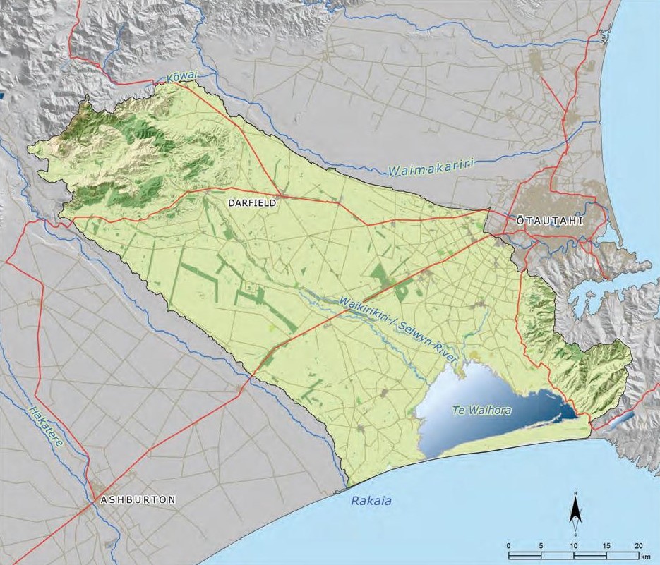
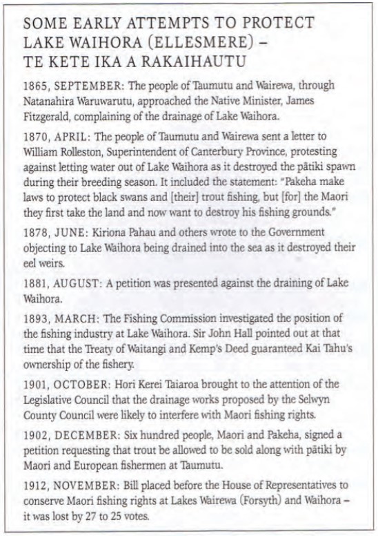
This section addresses issues of particular significance in the catchment of Te Waihora (Map 23). Te Waihora is a tribal taonga representing a major mahinga kai and an important source of mana. For the last 160 years, management of the lake and its catchment has reflected farming and settlement values, at the expense of Ngāi Tahu values. In its findings on Te Kerēme (the Ngāi Tahu Claim) the Waitangi Tribunal (1991) found that:

" Waihora was part of the area sold under the Kemp Purchase. Despite the importance of the lake to Ngāi Tahu as a food resource, despite the reservation of mahinga kai from the sale, despite acknowledgement from the Māori Land Court in 1868 that the tribe had always regarded this place as a valuable fishery and as the tribe’s most highly prized and valuable of all their possessions, despite strong protests by Ngāi Tahu over the years, no reserves of any kind were ever created over the lake to protect its use for Ngāi Tahu.

The tribunal, in looking at the evidence, concluded that Ngāi Tahu were the losers in a conflict between two economic systems with different priorities over different resources. On the one hand, Ngāi Tahu relied on their traditional economy and expected that their rights to mahinga kai would be reserved to them. On the other hand, the Crown saw that the Ngāi Tahu economy must not prevent the needs and demands of land settlement. The agricultural and pastoral demands won the conflict. As a result, Ngāi Tahu interests in Waihora have been completely disregarded." (1)

The effect of intensive land use on the lake, waterways and groundwater in the catchment is a key kaupapa in this section. A focus on Te Waihora is the means to ‘drive change from the bottom up’. Resolving the issues required to restore the cultural health of Te Waihora will ultimately restore the cultural health of the wider catchment.

Today the restoration and rejuvenation of the mauri and ecosystem health of Te Waihora is a reality. Ngāi Tahu and Environment Canterbury are implementing a co-governance agreement for the active management of Te Waihora and its catchment, and Whakaora Te Waihora, a long-term relationship agreement and shared commitment between the two parties for the ecological and cultural restoration of the lake, bringing together the tikanga responsibilities of Ngāi Tahu and the statutory responsibilities of the regional council.

Map 23: Te Waihora catchment

Map 23 Te Waihora catchment

NOTE: See Section 5.1 (Issue K1 - Recognising Manawhenua) for guidance on identifying the Papatipu Rūnanga with manawhenua and kaitiaki interests in this area.

Te Kete Ika a Rākaihautū

The original Māori name for Te Waihora was Te Kete Ika a Rākaihautū, the fish basket of Rākaihautū, named by Te Rakihouia after his father Rākaihautū, the captain of the Uruao waka known for using his famous kō (digging stick) to dig the principal lakes of Te Wai Pounamu. On his coastal journey south from Whakatū (Nelson) Te Rakihouia discovered the great flat plains of Canterbury, which he called Ngā Pākihi Whakatekateka o Waitaha, and the great coastal lake he described as ‘flat spread out water’ or Te Waihora. Te Rakihouia claimed the abundant resources of the area for his father and hence named the lake Te Kete Ika a Rākaihautū.

Ngā Paetae | Objectives

(1) Ngāi Tahu are active co-governors of Te Waihora and its catchment.
(2) Land and water management in the catchment effectively provides for the Treaty partner status of Ngāi Tahu, and the taonga status of Te Waihora.
(3) The cultural health of Te Waihora is restored, including the restoration of mahinga kai species abundance and diversity to a level to enable customary use.
(4) The customary rights of Ngāi Tahu whānui associated with mahinga kai and Te Waihora are protected mō tātou, ā, mō kā uri ā muri ake nei.
(5) Land and water use in the catchment respects the boundaries, availability and limits of our freshwater resources and the need to protect soil and water resources for future generations.
(6) The relationship between land use, groundwater, surface water and Te Waihora is recognised and provided for according to the principle of Ki Uta Ki Tai.
(7) Lake management, including lake level management, reflects living with the lake, rather than forcing the lake to live with us.
(8) The cultural health of lowland waterways is restored, through the restoration of water quality and quantity and riparian margins.
(9) Wetlands and waipuna are recognised and protected as wāhi taonga, and there is an overall net gain of wetlands in the catchment.
(10) All waterways have healthy, planted riparian margins and are protected from stock access.
(11) The discharge of contaminants to the lake and waterways in the catchment is eliminated.

Ngā Take | Issues of Significance

TW1: Governance and Management

Issue TW1: Improving the ability of Ngāi Tahu to exercise kaitiakitanga and influence decision making in the catchment.

Ngā Kaupapa / Policy

TW1.1 To continue to progress a formal co-governance arrangement, between Ngāi Tahu and Environment Canterbury for the active management of Te Waihora and its catchment.

TW1.2 To support Whakaora Te Waihora as a long-term relationship agreement and shared commitment between Ngāi Tahu and Environment Canterbury for the ecological and cultural restoration of Te Waihora.

TW1.3 To require that local authorities and water management structures recognise and provide for rangatiratanga and kaitiakitanga by:
(a) Recognising Te Rūnanga o Ngāi Tahu as owner of the Te Waihora lakebed; and
(b) Recognising and giving effect to the mandate of the Te Waihora Management Board to protect the tribal property right for the lakebed (see Issue TW2).

He Kupu Whakamāhukihuki / Explanation

A significant issue for Ngāi Tahu is the limited ability to effectively participate in and drive resource management decision making for the Te Waihora catchment. The current state of poor cultural health of Te Waihora and its catchment is evidence that water management and governance in the region has failed to effectively recognise and provide for kaitiakitanga and rangatiratanga.

Resolving this issue requires improved recognition of Ngāi Tahu as a Treaty partner, tāngata whenua and owner of the Te Waihora lakebed, and of the Te Waihora Management Board as representing the six hapū with kaitiaki interests in the lake. The long term objective for Papatipu Rūnanga is to establish a formal co-governance arrangement for managing the lake and its catchment, with statutory mechanisms for delivering significantly improved cultural health.

Cross reference:

» Issue TW2: Ngāi Tahu ownership of the lake bed
» Issue TW3: Te Waihora Joint Management Plan
» General policy on Kaitiakitanga (Section 5.1, Issue K3)

TW2: Ngāi Tahu Ownership of the Te Waihora Lakebed

Issue TW2: Effective recognition of Ngāi Tahu ownership of the Te Waihora lakebed.

Ngā Kaupapa / Policy

TW2.1 To continue to raise the profile and assert the rights of Te Rūnanga o Ngāi Tahu as owner of the Te Waihora lakebed.

TW2.2 To exercise the rights and obligations associated with Ngāi Tahu fee simple ownership of the bed of Te Waihora by:

(a) Holding a joint consent with the regional council for lake opening activities;
(b) Investigating the feasibility of appointing the Te Waihora Management Board as joint consent authority for all activities affecting the lake, under Section 33 or 36B of the RMA; and
(c) Requiring Ngāi Tahu approval on activities in the catchment that will directly affect the lake bed.

He Kupu Whakamāhukihuki / Explanation

Ownership of the Te Waihora lake bed was vested in Te Rūnanga o Ngāi Tahu in 1998 as part of the Ngāi Tahu Settlement. Since 1998, there have been a number of difficulties associated with exercising the rights and obligations resulting from this ownership. For example, Ngāi Tahu have limited control over how particular activities affect the lake bed, including the discharge of contaminants and sediment on the lake bed from adjacent land use and tributary inflow. One of the reasons for this is that tribal ownership of the lake bed is often viewed by external agencies and landowners as different from private ownership, likely because:
(a) The property is under water: if Ngāi Tahu owned the whole of the lake that status of property rights would be less of an issue; and
(b) The property rights are tribal property rights and not individual.

Cross reference:

» Issue TM3: Te Waihora Joint Management Plan 2005

TW3: Te Waihora Joint Management Plan

Issue TW3: Implementation and review of the Mahere Tukutahi o Te Waihora/Te Waihora Joint Management Plan 2005.

Ngā Kaupapa / Policy

TW3.1 To use the Te Waihora Joint Management Plan alongside the Mahaanui IMP to enable a holistic Ki Uta Ki Tai approach to resolving issues of significance for the Joint Management Area and the wider Te Waihora catchment.

TW3.2 To review the Te Waihora Joint Management Plan to assess progress and improve the ability of the plan to address and resolve issues of significance to Ngāi Tahu, including:
(a) Access to lake bed: currently Ngāi Tahu access provisions are generally limited to those of the general public;
(b) Inanga/whitebait: the Plan does not provide for the management, protection or enhancement of īnanga, as it cannot fully recognise the relationship between mahinga kai, tributaries and the lake (i.e. applies to lake bed only); and
(c) Building on the Plan to implement cogovernance of the Joint Management Area.

TW3.3 To work with the Department of Conservation to implement signage and interpretation policies and methods in the Joint Management Plan that inform and clarify public access (i.e. who owns what, who can go where, and what they can do there).

He Kupu Whakamāhukihuki / Explanation

The Te Waihora Joint Management Plan (TWJMP) provides a framework for a working relationship between Ngāi Tahu and the Department of Conservation, and policy guidance for addressing management issues associated with the lake bed and lake margins. The Plan has significantly raised the profile of Te Waihora and achieved a number of key outcomes desired by Ngāi Tahu, such as enabling the collection of swan eggs (see Case Study under Issue TW6), and implementing restoration programmes on lake margins. It also provides a framework to implement a permit system for commercial activities and uses of the lake bed.

However, there are a number of areas in which desired outcomes have not been achieved, including some access and mahinga kai issues. For example, tāngata whenua who fish for pātiki and tuna from the lake are subject to rules about how they access their land (i.e. foot access only), and these rules impede full access to mahinga kai resources.

A further issue is that the TWJMP applies only to the lake bed and specific land parcels around the lake. The plan does not include the water in the lake, and is unable to address the effects of catchment land use on lake health. Managing the lake bed separately from the water above it is an ongoing challenge for tāngata whenua, given the holistic approach of Ngāi Tahu to environmental management. The Mahaanui IMP addresses this issue by providing a values-based, Ki Uta Ki Tai planning document that can be used alongside the TWJMP to effectively address and resolve land use and water issues.

The TWJMP is effective for 10 years, or for an extended period as agreed by Te Rūnanga o Ngāi Tahu and the Minister of Conservation, but may be reviewed at any time as a result of increased knowledge, or changes in circumstance.

TW4: Cultural Health of Te Waihora

Issue TW4: The cultural health of Te Waihora is degraded as a result of:
(a) Lake margin land use and settlement, and reclamation of the lake;
(b) Land use in the catchment and effects on the lake and its tributaries; and
(c) Lake level management.

Ngā Kaupapa / Policy

TW4.1 To require that the management of land and water in the Te Waihora catchment recognises and provides for the relationship between catchment land use, tributary flow, drain management, water quality, the coastal environment and the cultural health of Te Waihora.

TW4.2 To require that Te Waihora is identified as a mahinga kai site and a wāhi taonga management area in the Selwyn District Plan, in addition to an ‘Outstanding Natural Feature and Landscape’, and that the plan contains provisions to protect these values.


Lakewater, groundwater and surfacewater

TW4.3 To advocate for the development of an integrated surface water/groundwater/lake-water management plan for the Te Waihora catchment, recognising and giving effect to:
(a) Mauri and mahinga kai as first order priorities;
(b) The relationship between groundwater and surface water;
(c) The relationship between tributary water quality and flow and the health of Te Waihora; and
(d) Effects of land use on water quality and quantity, particularly farm run-off.


Lake margin land use

TW4.3 To work with local authorities and the Department of Conservation to address the effects of lake margin land use and settlement on the cultural health of Te Waihora by:
(a) Securing a protected wetland margin around the lake to provide a buffer from land use and lake level changes;
(b) Establishing a process whereby the Te Waihora Management Board can require the Department of Conservation to revoke grazing licenses on lake margin conservation land where such licenses are resulting in adverse effects on Ngāi Tahu values and lake health;
(c) Investigating alternative locations or exit strategies for the Lower Selwyn Huts settlement;
(d) Investigating the development and use of zones around the lake to control the effects of land use, reflecting the:
(i) Sensitivity of the lake environment to a particular activity/degree of risk to lake health, and
(ii) Consistency of a particular activity with Ngāi Tahu objectives to manage the lake as mahinga kai.
(e) Prohibiting activities such as creation and use of offal pits, establishment of lifestyle block developments, and permanent settlement on lake margin land below 1.8 m above sea level.


Cultural health monitoring

TW4.5 To support the continued development of cultural health assessment tools and methods to understand and respond to issues of management importance to Te Waihora, and to require the acceptance of these tools as mainstream assessment and monitoring methods.

TW4.6 To investigate the tribal purchase of a boat to use on Te Waihora for the purposes of:
(a) Cultural health monitoring;
(b) Fulfilling kaitiaki/tāngata tiaki responsibilities;
(c) Research; and
(d) Access to lake edge sites not accessible by land, including tribal property.


Research

TW4.7 To increase Ngāi Tahu participation in defining research objectives and priorities for Te Waihora to ensure that research benefits Ngāi Tahu values, including mahinga kai.

TW4.8 To support and encourage ‘solution based research’ (i.e. will improve environmental outcomes for water quality in the lake, as opposed to providing evidence to support what we already know).

He Kupu Whakamāhukihuki / Explanation

Although Te Waihora continues to be a productive environment, its mauri is severely degraded as a result of a management regime that has consistently prioritised non-Ngāi Tahu values and interests (see Box - State of the Takiwā - Cultural Health Assessment for Te Waihora). Kaumātua describe Te Waihora as once clear with a shingle. Kaumātua describe Te Waihora as once clear with a shingle bottom, used as a source of drinking water, food and cultural resources (see Box - Kaumātua memories of Te Waihora).

Te Waihora has little protection from the effects of land use on its margins. Activities on the margins of the lake such as grazing, sewage discharge, and run-off have effects on lake health through direct environmental impact, and because they influence the lake level management (see Issue TW5). For example, the location of lake margin communities compromises the ability to raise lake levels and manage for fishery values. The protection of these communities (and what is essentially a non-existent private property right) is given priority over and above the tribal property right over the lakebed. The Te Waihora Management Board refers to this as a ‘superimposed priority to keep these settlements dry'.

Land use and tributary management in the wider catchment also contribute significantly to the degraded cultural health of Te Waihora. At the bottom of the catchment, Te Waihora is a sink for nutrients and sediment from its large and predominately agriculturally based catchment. Historically, extensive wetlands around the lake margins acted as a nutrient and sediment filter and played an important role in maintaining water quality, but these have been largely drained or degraded.

"I have noticed a change ever since farming began at the top end of Greenpark. Pollution and sediment from the farms has washed down into the lake."

“We shouldn’t be using the word ‘nutrients’ to describe what is going into our lake. Nutrients are associated with health and well being. What is going into our lake is pollutants and toxins.”

State of the Takiwā Cultural Health Assessment for Te Waihora

State of the Takiwā cultural health assessments undertaken at Te Waihora in 2007 found that:

  • The lake, and in particular the lake edge, still holds significant mahinga kai values, despite obvious water quality, modification, external pressure and native vegetation issues;
  • Te Waihora lake edge is in a state of moderate cultural health. Sites scored well on willingness to harvest mahinga kai and access indicators, but poorly on site pressure, modification and native species abundance indicators;
  • Just under half (42%) of the 12 sites tested failed the national recreation guidelines for water quality and no site achieved the shellfish/food gathering standard or was fit to drink. E. coli at 83% of the sites showed resistance to antibiotics, with Ampicillin (a human antibiotic) being the most common. The worst record was the Greenpark Sands site and the best was Pākoau; and
  • Kaitōrete Spit sites (Te Waiomakua and Harakeke Wetland) were the highest ranking sites, while Pākoau followed by the Kaituna River mouth site were the lowest scoring.

Takiwā Cultural Health Assessment scores for 14 sites at Te Waihora, with 0.0 being the lowest score and 5.0 the highest. Waihora Takiwā Scores

Waihora Takiwā scores

Source: Pauling, C. & Arnold, J., 2007. Cultural Health of the Lake. In: Te Waihora/Lake Ellesmere: State of the lake and future management, Hughey, K. & Taylor, K (editors), pp. 77 – 82

Kaumātua memories of Te Waihora

Ngāi Tahu kaumātua have vivid recollections of the Te Waihora environment not so long ago, and today the kaumātua advise that it is not enough to talk about improving or enhancing the lake – we now have to focus our efforts on saving it.

Kaumātua recollections of Te Waihora:

  • clear with a shingle bottom
  • used as a source of drinking water
  • large pipi in the lake bed
  • a much higher lake covered a much larger area
  • abundance of tuna in Te Koru
  • healthy large pātiki
  • we have access to the whole of the lake
  • abundant traditional resources that were safe to eat -watercress, puha, tuna, herring, pātiki, smelts, īnanga
  • higher salinity, as the lake was open for longer periods of time
  • more fluctuation of wet and dry at Greenpark Sands, and a more productive environment for waterfowl and other birds.

Source: IMP hui, Ngāti Moki Marae, 2010 ​

Cross reference:

» Issue TW5: Lake level management
» Issue TW6: Mahinga kai
» Issue TW7: Cultural health of lowland waterways and groundwater

TW5: Lake Level Management

Issue TW5: Lake level management must be consistent with the protection and restoration of Ngāi Tahu customary values and interests associated with Te Waihora.

Ngā Kaupapa / Policy

TW5.1 To require that lake level management and lake openings are jointly managed by Ngāi Tahu and Environment Canterbury, recognising Ngāi Tahu as tāngata whenua, Treaty partner and owner of the Te Waihora lake bed.

TW5.2 To continue to pursue a lake opening regime that provides for improved recognition, protection and enhancement of mahinga kai (fisheries) values and other outstanding cultural characteristics associated with Te Waihora. This means:
(a) A process of managed lake openings that allow for:
(i) Increased fish recruitment;
(ii) Higher and fluctuating lake levels;
(iii) Salinity maintained at a higher level than current regime allows;
(iv) Longer duration of openings when required for fish values; and
(v) Allowing the lake to be tidal for longer periods of time.

(b) The investigation of opening the lake at the southern end of Te Koru, in addition to, or instead of, the current site.
(c) Adaptive management, allowing the lake to be opened on a seasonal, opening-by-opening basis, guided by general rules and criteria rather than set target levels.

He Kupu Whakamāhukihuki / Explanation

Ngāi Tahu historically opened Te Waihora using kō and tākoko. The lake was opened when it threatened to flood the pā at Taumutu and occupation sites around its shores, or when fisheries values required it. People in settlements as far south as Awarua knew that the lake had been opened by the appearance of distinctive pātiki mohoao in their rivers. The difference between these historical openings and openings in the last century is that Ngāi Tahu worked with the lake rather than against it.

With European settlement, larger scale drainage and flood management replaced water quality and fish migration as the drivers for lake openings:

"At Lake Ellesmere (then called Waihora) I showed Maopo, Pohau, and others of the Kaiteruahikihiki interested at Taumutu that although years might elapse ere their old style of breaking the dam might be interfered with, the stoppage of the outlet must so seriously affect the drainage of so large an extent of country that the Government must be quite free to do as it pleased with regard to it." (3)

As early as 1856, Ngāi Tahu sought to have the issue of drainage of Te Waihora addressed (see Box - Early attempts to protect Te Waihora). Ngāi Tahu continue to pursue a lake opening regime that provides for improved recognition, protection and enhancement of mahinga kai values. It is anticipated that the recent amendments to the National Water Conservation (Te Waihora/Lake Ellesmere) Order 1990 will assist with this goal.

"We accept that the lake will always be lower than it was historically, but in saying that we must manage for values not levels." (4)

Some early attempts to open te waihora newspaper clipping

Source: Dacker, B. 1990. The people of the place: Mahinga kai. New Zealand 1990 Commission.

Cross reference:

» Issue TW4: Cultural health of Te Waihora

Information resource:

» Cultural Impact Assessment Report for activities associated with the opening of Te Waihora, 2003. Prepared by Jolly, D., with Te Taumutu Rūnanga and Te Rūnanga o Ngāi Tahu, for Environment Canterbury.

TW6: Mahinga kai

Issue TW6: Loss of mahinga kai resources and opportunities in Te Waihora and its catchment as a result of:
(a) Decline in species health, abundance and diversity;
(b) Poor cultural health of traditional mahinga kai sites;
(c) Loss of or poor physical access to mahinga kai areas;
(d) Adverse effects on native species as a result of introduced species; and
(e) Commercial fishing in Te Waihora.

Ngā Kaupapa / Policy

Customary rights to mahinga kai

TW6.1 To require that Te Waihora and its tributaries are managed as a customary fishery first and foremost, including but not limited to:
(a) A lake opening regime the reflects the needs of the customary fishery (see Issue TW5);
(b) Tributary water quality and quantity that enhances cultural health and mahinga kai, and enables customary use (see Issues TW7 and TW8);
(c) Restoration of the cultural health of and physical access to key mahinga kai sites and resources around the lake; and
(d) The use of exclusion zones for commercial fishing / non-commercial fishing areas.

TW6.2 To require that Ngāi Tahu customary rights to mahinga kai are recognised, protected and enhanced.

TW6.3 To require that any mechanism, plan or policy designed to recognise and protect the values of Te Waihora confirms the status of Ngāi Tahu as tāngata whenua, the mana of Ngāi Tahu as landowner, and the customary importance of the lake as mahinga kai (see Box – Establishing Te Waihora as a Mahinga Kai Cultural Park).

TW6.4 To nurture and teach our tamariki and mokopuna about the mahinga kai traditions associated with Te Waihora and its tributaries.


Priority areas

TW6.5 To require that the health of, and physical access to, mahinga kai sites and places within the Te Waihora catchment is restored, including but not limited to: (a) Muriwai;
(b) Greenpark Sands;
(c) Pākoau;
(d) Kaitōrete;
(e) Kaituna kōhanga (Kaituna end);
(f) Waikirikiri;
(g) Waiwhio;
(h) Halswell River;
(i) Ahuriri Reserves; and
(j) Yarrs Lagoon.

TW6.6 To highlight the need to protect long fin eel (Anguilla dieffenbachii) as a matter of priority, given the significant and ongoing decline of these species in Te Waihora.


Access

TW6.7 To develop and implement Ngāi Tahu-specific mahinga kai based access provisions for Te Waihora including: (a) Vehicle access to particular areas for mahinga kai activities where such access is determined by tāngata whenua to be necessary and will avoid effects on mahinga kai or ecological values; and (b) The ability for Ngāi Tahu to constrain access to specific areas at specific times of year, for the purposes of avoiding adverse effects on the lake bed, mahinga kai or other cultural values.


Cultural health monitoring

TW6.8 To support cultural health monitoring of mahinga kai species in Te Waihora, the lake margins and tributaries, including but not limited to: (a) Tuna, particularly longfin; (b) Pātiki; (c) Kāki anau; and (d) Kokopu, as a good indicator species.

TW6.9 To investigate the implementation of a programme to test hua kāki anau for the presence of contaminants, given the reliance of kāki anau on the lake as a food source.


Non-commercial areas

TW6.10 To support existing non-commercial fishing areas in Te Waihora, and investigate the establishment of additional exclusion areas.

He Kupu Whakamāhukihuki / Explanation

Mahinga kai is one of the most important cultural values in the Te Waihora catchment. The importance of the lake as mahinga kai was reinforced by the Waitangi Tribunal in its conclusions and recommendations in the Ngāi Tahu Sea Fisheries Report 1991. The Tribunal recommended that the lake be returned to Ngāi Tahu as a fishery (Section 14.3.4). The ability of Te Waihora to sustain people as a mahinga kai is reflected in a whakataukī from Taumutu that refers to the year round availability of food at Orariki, when at other places food was only available at certain times of year:

Ko ngā hau ki ētahi wāhi, ko ngā kai ki Orariki.
No matter which way the wind blows, you will always eat at the pā of Orariki, Taumutu


Tāngata whenua continue to value mahinga kai activities as an important expression of cultural identity. The loss of mahinga kai resources and opportunities in the catchment is significant, given the highly modified agricultural landscape, degraded water quality and quantity, and loss of physical access (see Case Study - Cultural harvest of hua kāki anau).

"Ngāi Tahu should have full and unimpeded access to the lake bed and margins, as owner and as tāngata whenua, as guaranteed by Te Tiriti o Waitangi."

"I will never get over the Crown coming in and disregarding our Treaty right to fish in Te Waihora. We lost the ability to make a living and earn an income to feed our family. We were left with a customary right to fish, but not one that included the right to fully sustain our whānau."

Establishing Te Waihora as a Mahinga Kai Park

Any proposal to recognise and protect the immense cultural and ecological significance of Te Waihora must confirm the status of Ngāi Tahu as tāngata whenua, the mana of Ngāi Tahu as landowner, and recognise the customary importance of the lake as mahinga kai.

One option being considered by Ngāi Tahu is the establishment of Te Waihora as a Mahinga Kai Park. The establishment of mahinga kai parks in the takiwā of each
Papatipu Rūnanga is one of the key environmental outputs identified in Ngāi Tahu 2025.

A mahinga kai park can be considered somewhat as a national park. The purpose of the park is to protect and sustainably manage the lake and the species that reside there, with emphasis on those species of customary importance to tāngata whenua, as well as establishing conditions on access and use. However, unlike a national park, customary use occurs alongside conservation, and is given priority over other kinds of use.


Key features of a mahinga kai park:

  • use and access to mahinga kai have the highest status;
  • the protection of customary species is paramount;
  • tāngata whenua are the primary decision makers;
  • cultural wānanga are held to restore and pass on traditional tikanga;
  • some areas are set aside for exclusive use by tāngata whenua;
  • both customary and commercial use can be provided for, but commercial use cannot occur at the expense of customary; and
  • where commercial activities (concessions or other) occur, they would provide benefit to tāngata whenua.

Source: Te Taumutu Rūnanga Natural Resource Management Plan (2003).

CASE STUDY: Cultural harvest of hua kāki anau on Te Waihora

Hua kāki anau or black swan eggs were a very important seasonal mahinga kai for Ngāi Tahu at Te Waihora. Under the authority of the Acclimatisation Society swan egg collection become an illegal activity in the century. Rangers were employed to camp up towers overlooking the swan breeding areas to deter would be egg gathers. By the 1960s there were over 80,000 birds on the lake, but this population was significantly reduced following the Wahine Storm of 1968.

A permit to gather eggs was recently granted to Ngāi Tahu by the North Canterbury Fish and Game Council. Following the first legal swan egging in over a century, there were many positive reports of sponges, birthday cakes, omelets and
scrambled eggs. Mātauranga was also shared with rangatahi by their kaumātua, therefore ensuring the continuity of this practice.

Notwithstanding the restoration of Ngāi Tahu customary rights to harvest hua kāki anau, there remain a number of
barriers to the full re-establishment of this cultural practice, including:

  • Swans nest largely on private land and access is limited by 4WD vehicle or boat, and dependent on landowner consent; and
  • Sites are severely degraded in terms of indigenous vegetation and erosion is rapidly destroying the main nesting area.

Further research and understanding is required to ensure that the harvest of hua kāki anau is a sustainable mahinga kai practice into the future. Cultural health assessment provides a tool to compile a data set to further this goal.

Source: Pauling, C. and Arnold, J. 2008. Cultural Health of the Lake. In: K. Hughey and K. Taylor (eds.), Te Waihora/Lake Ellesmere: State of the Lake and Future Management. Lincoln University

Cross reference:

» Issue TW3: Implementation and review of the Te Waihora Joint Management Plan
» Issue TW4: Cultural health of Te Waihora
» Issue TW5: Lake level management
» General Policy on mahinga kai (Section 5.5, Issue TM1)
» Section 6.12 (Rakaia to Hakatere) – Issue RH2 (see Box – Taiaroa 1880 Mahinga kai map)


Information resource:

» Te Taumutu Rūnanga and Te Waihora Eel Management Committee: Nature and extent of Te Waihora. Customary Eel Fishery – Mahinga Tuna kei Te Waihora (prepared by D. O’Connell).
» Waitangi Tribunal. 1991. Ngāi Tahu Sea Fisheries Report.

TW7: Cultural Health of Lowland Waterways and Groundwater

Issue TW7: The cultural health of lowland waterways and groundwater is degraded as a result of:
(a) Diffuse and point source pollution sourced from intensive rural land use;
(b) Sewage and stormwater disposal associated with urban and subdivision activities;
(c) Inappropriate drain and waterway management;
(d) Low flows due to excessive surface and groundwater abstractions;
(e) Drainage of wetlands and degradation of riparian areas; and
(f) Over-allocation and increasing demand for more water.

Ngā Kaupapa / Policy


Water quality

TW7.1 To require that the restoration of water quality in lowland streams is addressed as a matter of priority in the takiwā, to enable Ngāi Tahu and the wider community to fish, swim and engage with our waterways as we once did.

TW7.2 To require that water quality issues in the catchment area addressed as per general policy on Water quality (Section 5.3 Issue WM6) and on the Effects of rural land use (Section 5.3 Issue WM7), with particular attention to: (a) The specific nature of the catchment i.e. lake as a sink at the bottom of the catchment, absorbing the pollutants that flow into it from tributaries, drains and farm run-off; and
(b) The need for polluters to be held responsible for their effects on water quality and lake health.

TW7.3 To advocate that existing irrigated and other forms of intensive land use in the Te Waihora catchment require resource consent to continue operating, when the activity:
(a) Has a history of non-compliance;
(b) Is located below 1.8 m above sea level when adjacent to Te Waihora; and/or
(c) Is adjacent to a surface waterway.


Water quantity

TW7.4 To require immediate and effective steps for addressing over-allocation, as per general policies on Water quantity (Section 5.3 Issue WM8), with particular emphasis on:
(a) Controlling irrigated and intensive land use activities that affect surface water flow and groundwater recharge.

TW7.5 To require that environmental flow and water allocation regimes for the waterways in the Te Waihora catchment deliver the cultural outcomes set out in general policy on Water quantity (Section 5.3 Issue WM8), with particular emphasis on:
(a) Improving flow and water quality in lowland streams and the tributaries of Te Waihora; and
(b) Protecting water quality in aquifers and aquifer recharge.

TW7.6 To oppose the abstraction of water from the following wāhi taonga waterways: (a) Waikekewai.


Water enhancement schemes

TW7.7 To oppose any water enhancement scheme that will result in further adverse effects on Te Waihora. The cultural bottom line is that the only acceptable effects on Te Waihora are positive effects.

He Kupu Whakamāhukihuki / Explanation

Uncontrolled intensive land use is degrading water quality in lowland waterways and groundwater resources in the Te Waihora catchment, as evidenced by the inability to use many waterways for mahinga kai or swimming, and the occurrence of nitrate contamination in community groundwater supplies. Increasingly, phosphorus, nitrate, and faecal coliform concentrations in both ground and surface water exceed aquatic health and recreation use standards (see Case Study - Lynton Dairies Ltd vs. Canterbury Regional Council). Some communities continue to use waterways as a receiving environment for stormwater and overflows of wastewater.

"It is unacceptable that we cannot swim or fish in the Waikirikiri in the summer months, and that those who are directly contributing to the degradation of the awa are not being held responsible. Rather, they continue to make money while the community and the river bear the cost."

The demand for water for intensive land use has severely reduced flows in lowland spring fed waterways such as the Waiwhio, which now goes dry in the summer months. The Rakaia-Selwyn and Selwyn-Waimakariri groundwater zones are red zones, meaning that the total amount of groundwater currently allocated exceeds the allocation limit. Existing and continuing pressure on water resources is directly contributing to the degraded cultural health of waterways. The cultural health of the lake is directly related to the waterways flowing into it, and every tributary has a role in maintaining a healthy lake environment. At the ‘bottom of the catchment’ Te Waihora is a reflection of how land and water is managed in the catchment.

A significant kaupapa for Papatipu Rūnanga is the need to rethink the way water is valued and used in the catchment. An assessment of the kinds of land use that water is supporting in the catchment is a necessary prerequisite to looking for ways to secure more water.

CASE STUDY: Comments from Environment Court members regarding a site visit to the Te Waihora catchment [Lynton Dairies Ltd vs. Canterbury Regional Council (C108/05)]

[97] To the east of State Highway 1 things change significantly. The area has clearly been subject to extensive land management over the last 100 years, with the aim of converting what was formerly wetlands to pastoral farm land. Much of that is now occupied by dairying and is extensively irrigated. There was very limited evidence to satisfy us that there had been active management of the waterways in this area and we were disappointed to see waterways, including the Irwell, Selwyn, Hanmer Drain, Doyleston, Boggy Creek and Hart Creek all subject to little or no riparian planting or fencing.

[100] We were shocked at the ever-present effluent smell from all of these waterways and the clear evidence of poor management, excess effluent levels and contamination.

[101] Te Waihora (Lake Ellesmere) was a significant shock to the Court. The lake is eutrophic, green in colour and seems to be devoid of any riparian management. For example, stock seem to have free access to the water, the margins appear to be subject to chemical spraying regimes and lake levels manipulated for farming rather than the natural values. The lake water is in a serious ecological condition and is in urgent need of attention. Riparian management is required as an absolute minimum.

Cross reference:

» Issue TW4: Cultural health of Te Waihora
» General policies in Section 5.3 – Issue WM6: Water quality; Issue WM7: Effects of rural land use on water; Issue WM8: Water quantity; and Issue WM9: Regional water infrastructure
» General policy on Papatūānuku (Section 5.4, Issue P1)

TW8: Wetlands, Waipuna, and Riparian Margins

Issue TW8: Degradation and loss of wetlands, waipuna and riparian margins, and the tāngata whenua values associated with them, as a result of:
(a) Drainage;
(b) Diffuse pollution from intensive land use;
(c) Exotic vegetation (e.g. willow) and other weed or invasive species; and
(d) Stock grazing.

Ngā Kaupapa / Policy

TW8.1 To require that the wāhi taonga status of wetlands, waipuna and riparian margins is recognised and provided for in the catchment, as per general policy on Wetlands, waipuna and riparian margins (Section 5.3 Issue WM13).

TW8.2 To require that the following culturally significant wetland areas are protected and enhanced as a matter of priority:
(a) Muriwai;
(b) Te Waiomākua;
(c) Ahuriri Reserves (Ahuriri Lagoon);
(d) Yarrs Lagoon;
(e) Motukarara wetlands; and
(f) Oxbows and wetlands associated with the Waikirikiri River

He Kupu Whakamāhukihuki / Explanation

Wetlands, waipuna and riparian margins are taonga to Ngāi Tahu, providing rich sources of mahinga kai, and treasured for their natural ecosystem functions that protect and improve mauri. Wetlands and riparian margins associated with waterways such as the Waikirikiri and Waiwhio were once important for the harvest of cultural resources such as harakeke, but have since suffered a profound loss of these values. Te Waihora was once surrounded by extensive and diverse wetlands that were valued as part of the wider Te Waihora mahinga kai resource. Wetlands such as Muriwai had strong mahinga kai traditions (see Case Study on Muriwai, Section 5.6, Issue TAN3). The vast majority of original wetland area has been drained for settlement and agriculture, with only remnant wetlands remaining as a narrow fringe around the lake, such as Te Waiomākua and Ahuriri. Re-establishing a wetland margin around the lake as a buffer from land use is a key method for restoring cultural health of the lake (Issue TW4).

Cross reference:

» General policy on wetlands, waipuna and riparian margins (Section 5.3, Issue WM13)
» General policy on coastal wetlands, estuaries and hāpua (Section 5.6, Issue TAN3)

TW9: Wāhi Tapu me Wāhi Taonga

Issue TW9: Protection of wāhi tapu me wāhi taonga in the Te Waihora catchment.

Ngā Kaupapa / Policy

TW9.1 To utilise the methods set out in general policy Section 5.8 (Issue CL1: Cultural Landscapes, and Issue CL3: Wāhi tapu me wāhi taonga) to protect wāhi tapu and wāhi taonga in the catchment from inappropriate land use, subdivision and development.

TW9.2 To recognise and provide for the following sites and places as examples of Ngāi Tahu cultural landscapes of particular importance in the catchment:
(a) Te Waihora and its margins and associated wetlands;
(b) Coastal area from the Rakaia River to Taumutu, including Muriwai;
(c) Waikirikiri;
(d) Kaitōrete Spit; and
(e) Upper catchment of Waikirikiri.

TW9.3 To review all maps, schedules and provisions in the Selwyn District Plan that relate to wāhi tapu and wāhi taonga, following completion of the Ngāi Tahu Cultural Heritage Mapping Project (see Section 5.8 Issue CL2).

TW9.4 To recognise and provide for the following NTCSA 1998 provisions as cultural landscape indicators:
(a) The use of the ancestral names Waikirikiri (Selwyn River) and Muriwai (Coopers Lagoon), as per Dual Place names provisions;
(b) Land vested to Te Rūnanga o Ngāi Tahu in Fee Simple Title - Te Waiomākua, Greenpark Huts, and Whakamātakiuru (Ellesmere Landing);
(c) Vesting of the bed of Te Waihora and Muriwai (Coopers Lagoon) in Te Rūnanga o Ngāi Tahu; and
(d) Long term lease of Pākoau and Waikirikiri sites to Te Rūnanga o Ngāi Tahu.

He Kupu Whakamāhukihuki / Explanation

Ngāi Tahu associations with Te Waihora and the wider catchment are a reflection of the catchment’s richness as mahinga kai. Food gathering sites, food production sites, kāinga and nohoanga are key features of the cultural landscape. Concentrated areas of settlement existed adjacent to Te Waihora, in the lower reaches of the Waikirikiri, and at Kākāpōtahi near Hororata and Homebush. Other important cultural landscape features include wāhi pakanga, pā, urupā, tūāhu and maunga. The protection of wahi tapu and wāhi taonga is an essential part of recognising and providing for the relationship of Ngāi Tahu with the catchment.

Given the richness of cultural and historic heritage values associated with this catchment, a cultural landscape approach is the most appropriate way to manage and protect wāhi tapu and wāhi taonga. A cultural landscape approach shifts the focus from individual sites to the landscapes that they occur in.

Cross reference:


» General policies in Section 5.8 – Issue CL1: Cultural Landscapes; Issue CL2: Ngāi Tahu Cultural Mapping Project; Issue CL3: Wāhi tapu me wāhi taonga; and Issue CL5: Access to wāhi tapu and wāhi taonga
» Appendix 5: Archaeological sites, Wāhi taonga management sites and wāhi taonga management areas in the Selwyn District

TW10: Coastal Erosion

Issue TW10: Coastal erosion along the Taumutu coastline and effects on:
(a) The lake opening management regime; and
(b) Wāhi tapu and wāhi taonga, including urupā.

Ngā Kaupapa / Policy

TW10.1 To encourage research on the nature, extent and effects of coastal erosion on the Te Waihora and Taumutu coastline, in particular:
(a) An analysis of historical data, including maps, aerial photos and Ngāi Tahu oral history, to improve understandings of changes to the Taumutu coastline over time, including Te Koru;
(b) Relationship between changes to the volume and size of sediment being transported down the Rakaia River, due to low flows, and erosion of the Taumutu coastline;
(c) Relationship between coastal erosion and lake opening activities: are lake opening activities affecting erosion rates and will erosion rates necessitate a change in the location of the opening?; and
(d) The potential risk to sites of significance, including the Hone Wetere Church and urupā as a consequence of coastal erosion processes.

He Kupu Whakamāhukihuki / Explanation

Erosion of the Taumutu and the Te Waihora coastline is most noticeable along the southwestern side of the lake, on the Taumutu commonage land, and along the Kaitōrete Spit end of the Kaituna Lagoon. Erosion is a natural process as the coastline responds to sea level changes over time, but tāngata whenua believe that changes to the volume and size of gravels being deposited on the coast from braided rivers such as the Rakaia, fluctuating lake levels, high sediment loads in the lake and wind activity are accelerating the rate and changing the nature of natural erosion processes.

Further research is required to understand the nature and extent of coastal erosion along the Taumutu coastline. The results of this research will enable Ngāi Tahu and other agencies to better understand the drivers of coastal erosion and the nature and extent of potential effects.

"Kaikanohi, a fishing camp and settlement on Kaitōrete Spit provided a place to reside when traveling down the Spit if the lake was open. Evidence of tool making, pounamu working and bird and fish preservation have been found at the site, which is now subject to erosion from the sea." (5)

TW11: Kaitōrete Spit

Issue TW11: Protecting Ngāi Tahu values associated with Kaitōrete Spit, including:
(a) Wāhi tapu me wāhi taonga, including archaeological sites;
(b) Wetlands; and
(c) Indigenous biodiversity, particularly pīngao.

Ngā Kaupapa / Policy

TW11.1 To require removal of stock from coastal wetlands areas of Kaitōrete Spit, including paddocks that contain remnant wetland vegetation.

TW11.2 To investigate changing lease conditions on land owned by Te Taumutu Rūnanga where issues such as vehicle access, exotic weeds, stock grazing and erosion are having adverse effects on Ngāi Tahu values on that land. This may include requiring leaseholders to fence land.

TW11.3 To identify the following sites and resources on Kaitōrete Spit as a matter of priority for restoration activities:
(a) Pīngao; and
(b) Te Waiomākua.

He Kupu Whakamāhukihuki / Explanation

Kaitōrete Spit is a significant cultural landscape associated with the Te Waihora catchment. The spit was the main access route used by Ngāi Tahu to travel from Taumutu to Te Pātaka o Rākaihautū. There are hundreds of archaeological sites on Kaitōrete Spit, including umu, midden and tool-making sites (see Appendix 2 – NZAA sites).

Kaitōrete is also the largest continuous remaining area of pīngao (Ficinia spiralisa) in Aotearoa, an endemic native sand binding sedge prized for weaving.

Cross reference:

» Section 6.10 (Te Roto o Wairewa), Issue W7
» General policy on wāhi tapu and wāhi taonga (Section 5.8, Issue CL3)

END NOTES / REFERENCES

  1. Waitangi Tribunal, 1991. Ngāi Tahu Land Report 1991, chapter 2, section 2.12.
  2.  Goodall, A. 1996. Te Waihora – Te Kete Ika. In: The Natural Resources of Lake Ellesmere (Te Waihora) and its Catchment. Canterbury Regional Council, p. 146.
  3. Letter from W. Mantell to the Native Under-Secretary Rolleston, 12 April 1866, as quoted in the Ngāi Tahu Land Report 1991, section 8.9.13.
  4. Te Waihora Management Board, 2003, as quoted in: Jolly, D., with Te Taumutu Rūnanga and Te Rūnanga o Ngāi Tahu, 2003. Cultural Impact Assessment Report for activities associated with the opening of Te Waihora.
  5. Te Waihora Joint Management Plan 2005:73