IMP: Ngā Take ā-hikawai Me Ngā Kaupapa | Catchments

6.4 Waimakariri

Wāhi Tuaono | Part 6

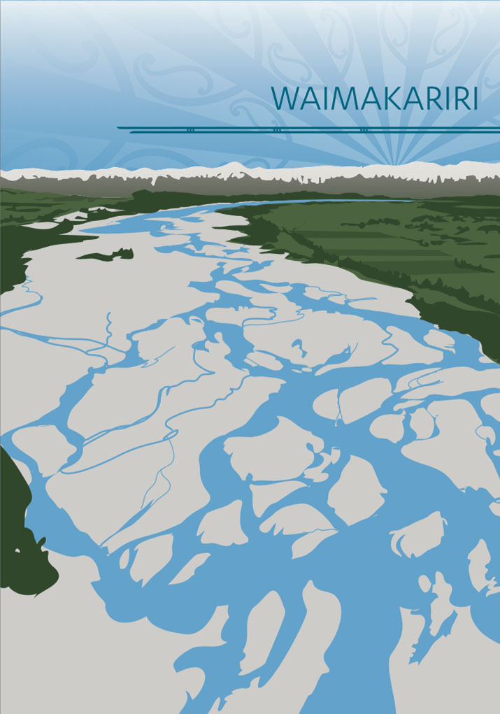
6.4 Waimakariri [WAI]

"The Waimakariri rises in the snows of the Southern Alps and its waters never fail. Like other snow fed rivers its flow tends to be greater in warm weather when the snows are melting [creating freshes]… Thus the natural tendency of the river is a periodic flushing out of its channels, which wind among braided shingle beds a kilometre wide when the level is low." (2)

Waimakariri

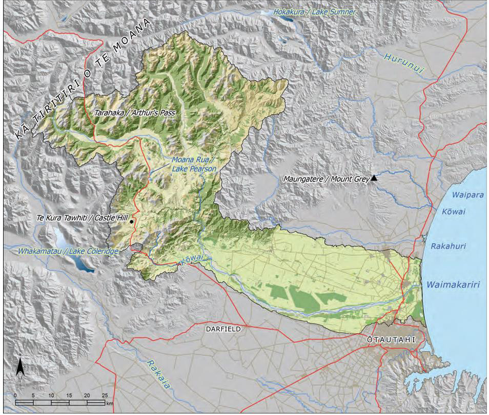
This section addresses issues of particular significance to the lands and waters of the Waimakariri catchment, a large catchment stretching from Ngā Tiritiri o Te Moana to Te Tai o Mahaanui to the high country, and encompassing a number of landscape features: mountains, high country lakes and wetlands, foothills, forests and grasslands, plains, spring fed lowland streams and coastal lagoons (Map 10).

The name Waimakariri refers to the cold (makariri)
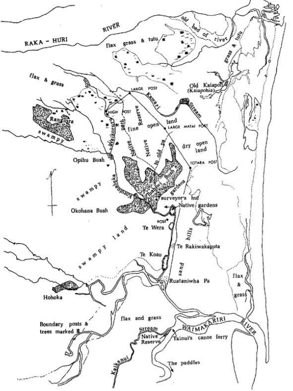
mountain fed waters of this braided river. The river was part of a larger network of ara tawhito linking the east coast of Te Waipounamu to the mahinga kai resources of the high country and the pounamu resources of Te Tai Poutini. The Waimakariri and its tributary the Ruataniwha (Cam River) were two of three waterways (the other being the Rakahuri) that continued to sustain Ngāi Tahu even after the land purchases in Canterbury. (1)  The region between the Waimakariri and Rakahuri River was of particular importance for mahinga kai.

The cultural, spiritual, historical and traditional significance of the Waimakariri landscape to Ngāi Tahu history and identity is acknowledged in the NTCSA 1998. Moana Rua (Lake Pearson) is a Statutory Acknowledgement site. Kura Tawhiti is a Statutory Acknowledgement site and a Tōpuni
(see Appendix 7 for schedules). The traditional place
names Maungatere (Mount Grey) and Kapara Te Hau (Lake Grassmere) are recognised under the Act’s dual place names provisions.

As with other braided river catchments in the region, the lower Waimakariri catchment is highly modified by human activity, while much of the upper catchment remains mountainous and wild; a source of life and nourishment for the plains and coast.

Map 10: Waimakarari catchment

NOTE: See Section 5.1 (Issue K1 - Recognising Manawhenua) for guidance on identifying the Papatipu Rūnanga with manawhenua and kaitiaki interests in this area.

Ngā Paetae | Objectives

(1) The natural “energy, vitality and life” of the Waimakariri River as a braided river is protected and restored.
(2) The discharge of contaminants to the Waimakariri and its tributaries is eliminated.
(3) Water quality and flows in the Waimakariri and its tributaries are improved to enable whānau and the wider community to have places they can go to swim and fish.
(4) The mauri and mahinga kai values of the Waimakariri and its tributaries and associated springs, wetlands and lagoons are protected and restored; mō tātou, ā, mō kā uri ā muri ake nei.
(5) Groundwater resources in the takiwā are protected from adverse effects associated with over-allocation and discharges.
(6) The coastal lowland region from the Waimakariri to the Rakahuri is recognised and provided for as a Ngāi Tahu cultural landscape of immense importance.
(7) The cultural and physical connectivity between the Waimakariri River, Kaiapoi pā, Taerutu lagoon, Tūtaepatu lagoon, Taranaki stream and the Rakahuri River is restored and protected.
(8) There is ongoing provision of opportunities to instill traditional values in our young people through involvement in restoration projects and customary mahinga kai practices.

Ngā Take | Issues of Significance

WA1: Water Quality

Issue WAI1: The discharge of contaminants to the Waimakariri River, it’s tributaries and Te Tai o Mahaanui is inconsistent with Ngāi Tahu values and interests.

Ngā Kaupapa / Policy


Discharges to the river

WAI1.1 To require the elimination of all industrial, stormwater and agricultural discharges into the Waimakariri as a matter of priority. The river must be able to be used for mahinga kai and recreation without concerns for human health.

WAI1.2 To oppose the granting of any new discharge to water consents in the catchment, or renewal of existing consents.


Discharges to Te Tai o Mahaanui

WAI1.3 To continue to advocate for a culturally sustainable alternative to the ocean outfall and the discharge of wastewater to the sea, consistent with general policy on opposing the use of water as a receiving environment for waste (refer Section 5.4 Issue P7 Waste management and Section 5.3 Issue WM6 Water Quality).

WAI1.4 To work with local government to progress policy WAI1.3, in anticipation of the 2039 expiry date for the consents associated with the ocean outfall.

WAI1.5 To require that the following measures are implemented as a matter of priority to address cultural issues associated with the existing wastewater treatment and ocean outfall infrastructure:
(a) Programs and incentives to minimise the volumeof waste entering the system;
(b) Increased level of treatment prior to discharge;
(c) Address leakage from the outfall pipe into water;
(d) Avoid any discharge of treated or untreated sewage to the Waimakariri River or its tributaries, in the case of overflow events or otherwise; and
(e) Monitoring programs for kaimoana.

WAI1.6 To require that sediment testing is undertaken at the following locations, to gain an understanding of the effects of historical industrial discharges (i.e. woollen mills, tanneries, freezing works) on the cultural health of waterways:
(a) Confluence of Kaiapoi and Waimakariri rivers;
(b) Kaiapoi river upstream from the confluence; and
(c) Ruataniwha.

He Kupu Whakamāhukihuki / Explanation

Ngāi Tahu fundamentally oppose the discharge of contaminants to water, including treated sewage. The historic and current discharge of sewage, industrial waste and agricultural waste has affected the mauri of the Waimakariri River and its tributaries, and the ability of tāngata whenua to use them as mahinga kai. In the 1960s and 1970s, many of the lower catchment waterways and wetlands became unusable as a reliable and safe source of food. The story is a common one: local families forced to stop harvesting mahinga kai and prevent tamariki from swimming in local waterways due to pollution.

"…Ngāi Tūāhuriri continued to use the Waimakariri during her [the late Rima Te Ao Tukia Bell] childhood. However Ngāi Tūāhuriri stopped using the river as they were being continually fined for catching salmon and a type of eel which was unique to the river. She also recalled using the lagoon Tutae Patu and the river Rua Taniwha (Cam). Tutae Patu and Rua Taniwha were two waterways once in continual use by Ngāi Tūāhuriri. Mrs Bell elaborated on how, during the summer time after school, all the families would journey to Rua Taniwha to catch eel, trout, wai kakahi and wai koura. The children would remain upon the river until evening and, having obtained their dinner, would return to their homes. The waterways sustained many Ngāi Tūāhuriri families during the depression. This continual use of the river slowly come to an end as the water quality declined and the once abundant food became virtually non-existent. Today eeling activities on the Rua Taniwha have all but ceased for lack of eels. Any that are caught are not held in high regard as the quality of the food has declined. Wai kakahi and wai koura no longer exist."(3)

Until recently a number of community sewage schemes discharged treated effluent into the Waimakariri River via the Cam and Kaiapoi Rivers. Wastewater is now discharged to an ocean outfall 1.5 kilometres out to sea, and the council holds consent allowing for discharges of treated or untreated sewage to the Waimakariri River in case of overflow events. While the ocean outfall enables the elimination of sewage discharges to local waterways, it also perpetuates the view that using water as the receiving environment for the discharge of contaminants is acceptable (dilution to pollution).

The ocean outfall consent was granted in 2004 for 35 years. It is imperative that Ngāi Tahu and local authorities begin discussions well before the consent expiry date to find a more culturally and environmentally sustainable option for wastewater management.

Eliminating the discharge of contaminants to water is one of the most important challenges in the Waimakariri catchment. According to the Waimakariri River Regional Plan (WRRP), as of March 2004 there were 69 discharge permits to surface water in the Waimakariri catchment, mainly for stormwater, agricultural waste and industrial waste. From a Ngāi Tahu perspective, it is priority to work towards eliminating these discharges and avoiding the consenting of any new discharges.

Importantly, local observations suggest that the resilience of the waterways is such that improvement in cultural health can be seen after only a few years once discharges have ceased. For example, tāngata whenua report significant improvements in the cultural health of the Ruataniwha River since the discharge of Rangiora town sewage ceased.

Cross reference:

» General policies in Section 5.4 – Issue P7: Waste
management; and Issue P8: Discharge to land
» General policy on water quality (Section 5.3 Issue WM6)

WAI2: Lowland Streams

Issue WAI2: Rural and urban land use continues to have effects on lowland waterways such as the Kaiapoi and Ruataniwha, and associated waipuna and wetlands.

Ngā Kaupapa / Policy


WAI2.1 To consistently and effectively advocate for a change in perception and treatment of lowland waterways in the catchment: from public utility and unlimited resource to wāhi taonga.

WAI2.2 To require that the value of lowland waterways in the Waimakariri catchment as mahinga kai is protected and restored, including but not limited to:
(a) Management focused on mauri and mahinga kai;
(b) Management according to Ki Uta Ki Tai, and therefore the maintenance of fish passage from source to sea;
(c) Elimination of point and non point source pollution;
(d) Protection of whitebait spawning areas (kōhanga), via rāhui; and
(e) Provisions for the connections between waterways, wetlands and waipuna.

WAI2.3 To continue to support the efforts of the Waimakariri District Council to establish and manage indigenous planted riparian areas along waterways in the catchment.

WAI2.4 To support the development and implementation of a lowland waterways programme in the Waimakariri catchment, using a combination of education, incentives and statutory provisions to encourage, assist and require landowners to protect and restore lowland streams, including but not limited to:
(a) Reducing sediment;
(b) Establishing riparian areas;
(c) Protecting waipuna (as the source of lowland streams);
(d) Fencing to avoiding stock access;
(e) Appropriate buffers from adjacent land use; and
(f) Protecting wetlands.

WAI2.5 To require that local authorities recognise and provide for the cumulative effects of lifestyle blocks and small holdings on spring fed lowland streams, including but not limited to:
(a) Water abstractions for domestic and stock purposes (which often includes irrigation);
(b) Leaching from septic tanks and drip lines;
(c) Sedimentation and contamination as a result of stock access to waterways and drains; and
(d) Sedimentation as a result of degraded or absent riparian areas on waterways and drains.

WAI2.6 To advocate for the following actions on individual lowland waterways as a matter of priority for lowland streams in the catchment:
(a) Catchment management plan for the Kaiapoi River network;
(b) Development of a minimum 20 metre wide margin and increased planting of indigenous vegetation for the Ōtukaikino stream; and
(c) Sediment testing on the Kaiapoi and Ruataniwha/Cam Rivers (see Policy WAI1.6).

WAI2.7 To require that all wetlands and waipuna in the Waimakariri catchment are recognised and provided for as wāhi taonga, as per general policy on Wetland, waipuna and riparian margins, Section 5.3 Issue WM13.

He Kupu Whakamāhukihuki / Explanation

Lowland streams in the Waimakariri catchment were historically significant sources of mahinga kai. However, physical modification for flood control, drainage, and pollution have significantly affected the ability of tāngata whenua to use these waterways as mahinga kai; and they continue to be at risk because they are located in densely populated areas where the predominant land uses are urban or rural-lifestyle.

The tributaries of the Waimakariri are all considered wāhi taonga, but the Kaiapoi, Ruataniwha, Pūharakekenui and Otukaikino are of particular cultural significance. These lowland streams are spring fed and have strong mahinga kai and wāhi tapu values. Tāngata whenua support the development of catchment management plans for these waterways as a tool to address the effects of rural and urban land use on lowland waterways, and the Kaiapoi River network should have priority. The waterways and springs associated with the Kaiapoi River are identified as under considerable pressure from land use.

“There needs to be some serious effort put into identifying [whitebait] spawning areas and protecting them.”

“The Kaiapoi River is often discoloured when it rains; this is from sedimentation and run-off from farm land.”

WA13: Groundwater

Issue WAI3: Protecting the quality, quantity and long term sustainability of the groundwater resource in the Waimakariri catchment from effects associated with:
(a) Prolonged and over application of effluent, agrichemicals and fertilisers on land;
(b) Abstractions of groundwater;
(c) Cumulative effects of septic tank discharges on lifestyle blocks; and
(d) Sustained periods of the Waimakariri River flowing at or near minimum flow.

Ngā Kaupapa / Policy


WAI3.1 To recognise and provide for the groundwater resource beneath the Waimakariri Rakahuri Plains as a wāhi taonga resource.

WAI3.2 To require that water management in the catchment recognises and provides for the relationship between groundwater and surface water as a matter of priority. This means:
(a) Flow and allocation regimes must provide a certainty of supply for groundwater recharge, along with ensuring that there is sufficient water in the river itself.

WAI3.3 To protect groundwater resources in the Waimakariri catchment from effects as a result of inappropriate or unsustainable land use and discharge to land activities (see Section 5.4 Issue P8).

WAI3.4 To require that local authorities recognise and provide for the cumulative effects of lifestyle blocks and small holdings on the quality and quantity of groundwater resources, including but not limited to:
(a) Water abstractions for domestic and stock purposes (which often includes irrigation); and
(b) Septic tanks and drip lines.

WAI3.5 To address the potential risk to groundwater resources as a result of sewage/wastewater disposal by advocating that:
(a) Any new rural residential or lifestyle block developments connect to reticulated sewage network, install community reticulated sewage systems, or establish a common disposal site;
(b) Existing small rural residential villages that currently rely on individual septic tanks should be connected to a community reticulated system; and
(c) Where individual septic tanks on farms or lifestyle blocks are used, the preference is a wastewater treatment system rather than septic tanks.

He Kupu Whakamāhukihuki / Explanation

The groundwater resource that lies beneath the Waimakariri Rakahuri/Ashley plains provides drinking water to the takiwā and feeds lowland waterways, and is of great significance to Ngāi Tahu and the takiwā as a whole. The effect on groundwater levels as a result of sustained periods of the Waimakariri River flowing at or near minimum flow is a significant concern for tāngata whenua. The waters of the river have an important role in groundwater recharge.

Groundwater resources can become contaminated when land becomes saturated as result of inappropriate discharge to land activities, intensive land use on soils that are highly permeable, or septic tank leaching. The risk of contamination is increased when groundwater is abstracted at unsustainable levels.

"Contamination of groundwater occurs when we create a space through over-abstraction. By taking too much groundwater we make room for contamination to occur."

"Water leaves the river below Halkett and recharges groundwater to the north and south of the river. The estimated range of this recharge is 3-12 cubic metres per second. A considerable groundwater resource is stored in the gravels beneath the plains and feeds a number of streams on the lower plains, including the Avon and Heathcote rivers."

WA14: Subdivision Development

Issue WAI4: Subdivision and development activities in the lower catchment have the potential to affect Ngāi Tahu values.

Ngā Kaupapa / Policy

WAI4.1 To require recognition that subdivision and development in the Waimakariri catchment has the potential to affect tāngata whenua values and interests, in particular:

(a) Lowland streams, drains, wetlands and waipuna, and the desire to manage these as mahinga kai;
(b) Mahinga kai resources and opportunities;
(c) Silent files; and
(d) Wāhi tapu and wāhi taonga (outside of silent file areas).

WAI4.2 To require that local government recognise and provide for the particular interest of Papatipu Rūnanga in subdivision and development activities in the Waimakariri catchment, including:
(a) Ensuring that engagement with the Papatipu Rūnanga is not limited to silent file or wāhi tapu triggers.

WAI4.3 To assess subdivision and development proposals in the catchment with reference to general policy on Subdivision and Development (Section 5.4 Issue P4).

Wāhi tapu wāhi taonga

WAI4.4 Wāhi tapu and wāhi taonga associated with the Waimakariri catchment are the responsibility of the Papatipu Rūnanga, and must be managed using protection mechanisms identified by the Papatipu Rūnanga as appropriate.

WAI4.5 To use the methods set out in general policy on Wāhi tapu me wāhi taonga (Section 5.8, Issue CL3), to protect wāhi tapu and wāhi taonga from inappropriate land use, subdivision and development.

WAI4.6 Silent files remain an appropriate mechanism for protecting sites of significance in the Waimakariri catchment, as per general policy on Silent Files, Section 5.8 (Issue CL4).

He Kupu Whakamāhukihuki / Explanation

The rezoning of rural land to enable subdivision and residential, rural residential or business development is an important issue in the Waimakariri catchment as existing settlements and business zones seek to expand and new rural land is targeted for residential development.

Increasing the density of residential, business and industrial uses of land can put further strain on the quality and quantity of freshwater resources, and increase the risk to wāhi tapu and wāhi taonga. There are four silent files in the Waimakariri catchment, clustered in the lower catchment area (see Appendix 6), indicative of the significance of wāhi tapu values. Conversely, development activities can also enhance cultural landscape values, including indigenous biodiversity, as evidenced by the extensive wetland developments as part of the Pegasus township.

It is important that subdivision and development proposals assess how the activity may affect Ngāi Tahu values, including the relationship of Ngāi Tahu to ancestral lands, water, sites, wāhi tapu and other taonga. General policy on subdivision and development (Section 5.4 Issue P4) provides information on the expectations and opportunities associated with subdivision and development activities from a Ngāi Tahu perspective, including stormwater and wastewater management, and design guidelines.

"What Pegasus has done with the wetlands…. if you could do this from the Rakahuri to the Waimakariri, this would be outstanding. A real asset to the region."

"Historically, the land upon which the Sovereign Palms development will stand was the ‘high ground’ behind the residence of one of the key Ngāi Tahu rangatira – Te Rakiwhakaputa – at the time of their migration onto the Canterbury plains and beyond. The landscape was part of a vast wetland ecosystem that included many spring fed streams and rivers of the finest water in Canterbury." (5)

Cross reference:

» General policy on silent files (Section 5.8 Issue CL5)
» General policy on subdivision and development (Section 5.4 Issue P4)
» Issue WAI5: Cultural landscapes


Information resource:

» Lenihan, TM., 2012. Sovereign Palms Cultural Impact Assessment. Prepared for Ngāi Tūāhuriri Rūnanga.

WA15: Cultural Landscapes

Issue WAI5: Recognising and providing for particular areas as cultural landscapes.

Ngā Kaupapa / Policy


Coastal region between the Rakahuri and the Waimakariri

WAI5.1 To recognise and provide for the coastal and lowland region between the Waimakariri and Rakahuri Rivers as a cultural landscape with significant historical, traditional, cultural and contemporary associations. This includes:
(a) Waimakariri River;
(b) Kaiapoi pā;
(c) Taerutu stream and lagoon;
(d) Tuahiwi MR873 and other Kaiapoi Māori Reserve lands;
(e) Tūtaepatu lagoon;
(f) Taranaki stream;
(g) Rakahuri estuary;
(h) Saltwater creek; and
(i) The physical and cultural connections between these places.

WAI5.2 To work towards restoring cultural and physical connectivity of the coastal lowland areas of the Waimakariri and Rakahuri rivers, and therefore the cultural landscape values of this important area.


Kaiapoi Māori Reserve lands

WAI5.3To require that local authorities give appropriate legal recognition to the rights of the owners of Māori reserve lands, particularly with regard to the purpose for which individual reserves were established and the importance of these reserves as cultural landscapes.


Kura Tawhiti

WAI5.4 To require that Kura Tawhiti is recognised and provided for as a cultural landscape with significant historical, traditional, cultural and contemporary associations; and
(a) A Statutory Acknowledgement and Tōpuni site as per Schedules 27 and 82 of the NTCSA 1998; and
(b) A place of cultural, natural, and ecological importance to Ngāi Tahu, the Department of Conservation, and the wider community.

WAI5.5 To work with the Department of Conservation to manage Kura Tawhiti as a cultural landscape, recognising the multiple values associated with this special place, while providing a secure basis to restore indigenous cultural and ecological landscape values.

WAI5.6 To advocate for a sign to be erected at Cave Stream to advise that it is a wāhi tapu site. This is not to restrict public access, but rather to enable others to know that Ngāi Tahu recognise the site as wāhi tapu so that they can make informed decisions.

He Kupu Whakamāhukihuki / Explanation

The whole of the Waimakariri catchment can be identified as a cultural landscape. Ngāi Tahu land use and occupancy extended from the mountains to the sea (and beyond) in this catchment. The traditional place names and other cultural landscape features associated with the lower Waimakariri catchment are evidence of the extensive use of the area.

"All along the river are kainga nohoanga, mahinga kai areas and wāhi tapu such as urupā." (6)

However, within this larger landscape of land use and occupancy particular areas are identified as cultural landscapes with significant historical, traditional, cultural and contemporary associations. The ability to designate particular areas as cultural landscapes enables tāngata whenua to provide for the physical and cultural connections and connectivity between particular places, sites and resources, rather than “dots on maps” (see Section 5.4 Issue CL1).

Examples of cultural landscapes of particular importance in the Waimakariri catchment are the coastal, lower catchment region between the Waimakariri and Rakahuri rivers (see Box - Rakahuri to the Waimakariri, a landscape of immense importance), the original Kaiapoi Māori Reserve 873 lands and Kura Tawhiti.

Historically the Waimakariri and Rakahuri catchments were linked through extensive coastal wetlands, waipuna and waterways. Kaiapoi pā was built on dunes surrounded by water deep and extensive enough that it was accessible by large waka from both the Rakahuri and Waimakariri River.7 While drainage, physical modification of waterways and the widespread removal of indigenous bush and other vegetation have forever changed the landscape (see Map 11 for an indication of what the catchment once looked like), its cultural, historical and traditional significance has not changed.

Rakahuri to the Waimakariri, a landscape of immense importance

“Before European settlement began in the 1850s, the lower reaches of the Waimakariri and Rakahuri (Ashley) connected with a maze of waterways and wetlands fed by underground springs of the purest artesian water, which nourished a wealth of mahinga kai rich in birdlife, eels, fish and natural vegetation. For this reason, when Crown Commissioner Kemp arrived in 1848 to purchase Canterbury, the Ngāi Tūāhuriri negotiators proposed to retain the 100,000 ha between the Waimakariri and Rakahuri, leaving the territory south of the Waimakariri for the Europeans. This arrangement was denied to them. Instead, their four hundred people were confined to a 1,000 ha reserve at Tuahiwi, with a promise that they would retain their mahinga kai, while the rest of the 100,000 ha they had asked for was allocated to (at first) a dozen or so settlers.”

Source: Evison, H. and Adams, M. 1993. Land of Memories. Tandem Press

Map 11: The Waimakariri Rakahuri Lowlands 1848 – 50, as Charles Torlesse and John Boys found it, and the native reserve which Alfred Wills surveyed in 1848.

Map 11: The Waimakariri Rakahuri Lowlands 1848 – 50, as Charles Torlesse and John Boys found it, and the native reserve which Alfred Wills surveyed in 1848.

Cross reference:

» General policy on cultural landscapes (Section 5.8 Issue CL1)
» Section 5.3 (Rakahuri): Issue R5
» Issue WAI11: Te Riu o Te Aika Kawa

WAI6: Water Quantity

Issue WAI6: Increasing demands for irrigation water in catchment and effects on the mauri and mahinga kai values of the Waimakariri.

Ngā Kaupapa / Policy

Coastal region between the Rakahuri and the Waimakariri
WAI6.1 To require that land use intensification in the catchment is managed so that there is no further decline in water quality in the catchment, and to recognise and provide for land and water capacity and limits, as per general policies on Water quality (Section 5.3 Issue WM6) and Papatūānuku (Section 5.4 Issue P1).

WAI6.2 To require that environmental flow and water allocation limits for the Waimakariri and its tributaries are consistent with tāngata whenua values associated with the river, and therefore deliver the cultural outcomes set out in the general policy on flows and allocation limits (Section 5.3 Issue WM8), with particular focus on:
(a) Avoiding prolonged low flows and protecting flow variability;
(b) Protecting the natural character of a braided river;
(c) Providing for the role of the river in groundwater recharge; and
(d) Providing for the relationship between tributary water quality and flow and the health of the river.

WAI6.3 To require that the frequency of good sized floods and freshes in the Waimakariri River are protected as a natural and necessary features of the river system, providing and restoring the following services:
(a) Fresh and flush Brooklands Lagoon;
(b) Clean out spawning gravels;
(c) Trigger spawning and migrations of mahinga kai species;
(d) Flush contaminants from the river;
(e) Replenish wetlands and groundwater, and keep river flows higher in summer months, through allowing floodwater to soak into the plains;
(f) Rearrange channels and clear islands of vegetation, including noxious weeds; and
(g) Enable downstream movement of boulders and sediments from the headwaters, that shape and structure the lower reaches of the river.

He Kupu Whakamāhukihuki / Explanation

The Waimakariri River and its tributaries are under considerable pressure. Tāngata whenua have ongoing concerns with the ability of existing flow and allocation regimes to safeguard the mauri of the river, and its tributaries and hydraulically connected groundwater, and to provide for the relationship of Ngāi Tahu to it.

There are two critical features that are relevant to management of the Waimakariri River and its catchment with regard to flow and allocation regimes: the need to avoid prolonged low flow events, and the importance of flow variability. The mauri of the Waimakariri River is about energy, vitality and life. As with other braided rivers, the Waimakariri is in a constant state of change. When flow and allocation regimes cause the river to exceed the natural range or boundaries of change through prolonged period of slow flows or “flattening” of natural flow variability, then the river’s mauri is compromised. Flow regimes which permit the river to be drawn down below the low flow threshold and that allow such flows to be maintained over prolonged periods of time are at odds with Ngāi Tahu values and the practice of kaitiakitanga (see Box - Cultural effects of prolonged low flows in the Waimakariri).

"Ngāi Tūāhuriri and Ngāī Tahu whānui have long understood that the effects of an activity on one resource can have further effects on that or other resources. I mentioned earlier the concerns of my ancestor Natanahira Waruwarutu about the draining of water from fishing reserves; the irony is not lost on me that 140 years later I stand here to voice the concerns of modern day Ngāī Tūāhuriri regarding the proposal to “drain” significant quantities of water from the Waimakariri." (8)

Cultural effects of prolonged low flows in the Waimakariri

Adverse cultural impacts that occur as a result of prolonged low flows in the Waimakariri River:

  • A reduction in the health and abundance of mahinga kai species and habitats;
  • A decline in the water quality of the river, as a result of there being less capacity for dilution of contaminants and increased erosion of river banks;
  • A rise in water temperature;
  • An increase in periodic low dissolved oxygen levels;
  • Changes to sediment deposition patterns;
  • A significant reduction in the ability of the river to recharge groundwater resources and, in turn, spring fed rivers and streams;
  • A likely drying out of river beds, with the potential for the loss of riparian margins and the unearthing of sites of significance;
  • Saltwater intrusion into areas beyond the usual tidal reaches of the river; and
  • A potential to unnaturally close the river mouth because of insufficient flows, thereby affecting native fish recruitment and migration.

Source: Te Rūnanga o Ngāi Tahu and Ngāi Tūāhuriri Rūnanga submission to proposed plan change 1 to the Waimakariri River Regional Plan.

Cross reference:

» General policies in Section 5.3 – Issue WM6: Water quality; Issue WM7: Effects of rural land use on water; Issue WM8: Water quantity; and Issue WM9: Regional water infrastructure
» General policy on Papatūānuku (Section 5.4 Issue P1)

WAI7: Drain Management

Issue WAI7: Management of drains can have adverse effects on Ngāi Tahu values, particularly mahinga kai.

Ngā Kaupapa / Policy

To require that drains are recognised and managed as natural waterways, as per general policy on Drain management (Section 5.3 Issue WM14), including:
(a) Continuing to work with the Waimakariri District Council to ensure that the timing and techniques of drain management are designed to reduce the impact of drain management on mahinga kai and water quality.

He Kupu Whakamāhukihuki / Explanation

Much of the land in the lower Waimakariri catchment was historically very swampy (see Map 11), and the existing drainage network was developed through these swampy areas. Tāngata whenua have a good working relationship with the Waimakariri District Council regarding drain management. For example, the use of the Southbrook drain for mahinga kai is recognised, as good watercress is found in close proximity to the spring-head. The council and the Papatipu Rūnanga also have agreements in place to put tuna back in drains following drain cleaning.

"All waterways – constructed or natural – provide habitat for aquatic life. Thus, while Fish and Game state the McIntosh’s Drain has no value as a fishery, it does for Mana Whenua as it continues to be part of a network of local waterways in which our surviving native fish (notably whitebait and eels) can find passage, food and shelter." (9)

Map 11: The Waimakariri Rakahuri Lowlands 1848 – 50, as Charles Torlesse and John Boys found it, and the native reserve which Alfred Wills surveyed in 1848.

Map 11: The Waimakariri Rakahuri Lowlands 1848 – 50, as Charles Torlesse and John Boys found it, and the native reserve which Alfred Wills surveyed in 1848.

Cross reference:

» General policy on drain management (Section 5.3 Issue WM14)

WA18: High Country Lakes

Issue WAI8: Protection of high country lakes and associated values from effects of land use.

Ngā Kaupapa / Policy

WAI8.1 To require the protection of tāngata whenua values associated with high country lakes in the Waimakariri catchment, including but not limited to:
(a) Mahinga kai;
(b) Wāhi tapu and wāhi taonga;
(c) Natural character; and
(d) Indigenous biodiversity.

WAI8.2 To require that the mana and intent the of the Statutory Acknowledgement for Moana Rua (Lake Pearson) as a contained within the NTCSA 1998 is recognised and provided for beyond the expiry of the Ngāi Tahu Claims Settlement (Resource Management Consent Notification) Regulations 1999.

WAI8.3 To continue to advocate for indigenous biodiversity protection and enhancement as important kaupapa for high country lakes.

WAI8.4 To protect high country lakes and their margins from sedimentation by:
(a) Requiring the protection of riparian areas and lake edge wetlands;
(b) Prohibiting stock access to the lake;
(c) Prohibiting the discharge of contaminants to water;
(d) Prohibiting inappropriate discharge to land activities that result in run-off into lake margins, including fertiliser application; and
(e) Prohibiting forestry activity on lake and tributary margins.

WAI8.5 To protect the cultural health of high country lakes from effects associated with abstractions from connected waterways and tributaries.

He Kupu Whakamāhukihuki / Explanation

There are more than twelve lakes and associated wetlands in the Waimakariri catchment including Moana Rua (Lake Pearson), Waikawa (Lake Lyndon), and Ōporea (Lake Hawdon). These lakes were important mahinga kai and camping sites associated with the network of high country trails used by Ngāi Tahu, and providing coastal communities with food, fibre and other resources.

Moana Rua is a Statutory Acknowledgement under the NTCSA 1998 (See Appendix 7). The Act acknowledges the site as primarily a mahinga kai site with weka, kākāpō and tuna being the main foods taken. Several urupā are also located in the immediate area.

Cross reference:

» General policies on Wai Māori (Section 5.3)

WA19: Wilding Trees

Issue WAI9: Control of wilding trees in high country and foothill regions.

Ngā Kaupapa / Policy

WAI9.1 To advocate for the eradication of wilding trees in the Waimakariri catchment, in accordance with general policy on Wilding trees (Section 5.4 Issue P15).

He Kupu Whakamāhukihuki / Explanation

Wilding trees are introduced conifer species that are self-sown or growing wild (i.e. naturally regenerating).

According to the Canterbury Regional Pest Management Strategy (2011), the Waimakariri River catchment is one of the worst affected areas in Canterbury. Wilding trees invade quickly and significantly, out-competing native vegetation and resulting in significant visual and ecological changes to the landscape.

Wilding trees can adversely affect cultural and historic sites and values. For example, a wilding tree invasion into Kura Tawhiti would significantly compromise the cultural values associated with the landscape, and Ngāi Tahu supported restoration efforts in this special place. A number of lodgepole pine (Pinus contorta), one of the most invasive conifer species, are located in the parking lot of Kura Tawhiti, posing a risk as a seed source for wilding tree establishment as far as Waikawa.

Cross reference:

» General Policy on commercial forestry (Section 5.4 Issue P14)
» General Policy on wilding trees (Section 5.4 Issue P15)

WA10: Te Riu o Te Aika Kawa / Pūharakeketapu

Issue WAI10: Use and management of Te Riu o Te Aika Kawa / Pūharakeketapu / Brooklands lagoon, in particular:
(a) Recognition of Ngāi Tahu associations;
(b) Water quality (e.g. stormwater discharges);
(c) Effects of recreational use on customary use (e.g. motorised craft use);
(d) Protection of mahinga kai habitat; and
(e) Protection of wāhi tapu and wāhi taonga values.

Ngā Kaupapa / Policy

WAI10.1 To avoid the use of Te Riu o Te Aika Kawa/ Pūharakeketapu as a receiving environment for the discharge of contaminants.

WAI10.2 To require that local authorities address and resolve issues associated with sediment and contaminant loading on this hapuā as a result of:
(a) Contaminants entering the hāpua from Waimakariri River inflow (i.e. industrial discharges);
(b) Contaminants entering the hāpua from Pūharakekenui, including urban stormwater water run off and discharges;
(c) Stormwater run-off from adjacent land use;
(d) Sediment from land use in the catchment.

WAI10.3 To promote the monitoring of water quality in Te Riu o Te Aika Kawa/Pūharakeketapu as a means to monitor the health the Waimakariri catchment, and to effectively manage land use and water quality throughout the catchment.

WAI10.4 To require that the hydrological dynamics of Te Riu o Te Aika Kawa/Pūharakeketapu are protected and enhanced to ensure the protection and enhancement of mahinga kai values.

WAI10.5 To ensure that tāngata whenua access to Te Riu o Te Aika Kawa/Pūharakeketapu for mahinga kai purposes is not compromised by other use, including recreational.

WAI10.6 To work with the Christchurch City Council to implement the Ngāi Tahu Objectives and Planning Proposals for the use and management of Te Riu o Te Aika Kawa/Pūharakeketapu, as set out in the Brooklands Lagoon/Te Riu o Te Aika Kawa Area Parks Master Plan (2010).

WAI10.7 To investigate the erection of signage at the Te Riu o Te Aika Kawa/Pūharakeketapu acknowledging the historic and contemporary importance of the hāpua as mahinga kai.

He Kupu Whakamāhukihuki / Explanation

Brooklands Lagoon, known both as Te Riu o Te Aika Kawa and Pūharakeketapu, is a coastal hāpua highly valued for mahinga kai resources such as tuna, kanakana, kōura and harakeke. There are also urupā and places of spiritual practice associated the area. Pūharakekenui flows into Te Riu o Te Aika Kawa, and there are strong cultural associations between the waterway and the hāpua, and other waterways and wetlands as far south as Te Waihora.

Maintaining water quality standards in the hāpua that enable quality mahinga kai habitat is an issue of significance for tāngata whenua. Local observation suggests that low flows in the Waimakariri are limiting the ability of the river to periodically flush the lagoon, and maintain mahinga kai habitat.

The Pūharakekenui Māori Reserve (MR892) is located adjacent to Te Riu o Te Aika Kawa, at the mouth of the Waimakariri. Te Hapū o Kati Urihia Ahu Whenua Trust is a land trust representing the owners of the reserve, the descendants of Urihia.

"Travis wetland area would have been open waterway, and there would have been connections all the way to Waihora. Waterways and wetlands linked important places such as Te Riu o Te Aika Kawa, Pūharakekenui, Ōtakaro and Te Waihora." (11)

"Low flows in the Waimakariri have adverse effects on Brooklands lagoon - the river doesn’t have the volume of water to fresh and flush the lagoon."

Cross reference:

» General policy coastal wetlands, estuaries and hāpua (Section 5.6 Issue TAN3)

END NOTES / REFERENCES

  1. Waitangi Tribunal, 1991. Ngāi Tahu Land Report 1991, chapter 17, paragraph 17.2.4.

  2. Evison, H., and Adams, M., 1993. Land of memories: A contemporary view of places of historical significance in the South Island of  New Zealand. Tandem Press.

  3. Waitangi Tribunal, 1991. Ngāi Tahu Land Report 1991, chapter 17, paragraph 17.3.7.

  4. Waimakariri River Regional Plan 2004, p.12.

  5. Lenihan, TM. 2010. Cultural Impact Assessment Report for Sovereign Palms Residential Development, Kaiapoi; p. 2.

  6. Tau, TM., Goodall, A., Palmer, D. and Tau, R. 1990. Te Whakatau Kaupapa: Ngāi Tahu Resource Management Strategy for the Canterbury Region. Aoraki Press: Wellington, 5-17.

  7. Allingham BJ., 2005. Retracing the 19th Century Landscape around Kaiapoi Pa. Unpublished Report for Te Ngāi Tūāhuriri Rūnanga and Te Rūnanga o Ngāi Tahu.

  8. Hullen, J., n.d. Statement of Evidence, Te Rūnanga o Ngāi Tahu and Ngāi Tūāhuriri Rūnanga submission to proposed plan change 1 to the Waimakariri River Regional Plan.

  9. Lenihan, TM., 2010. Cultural Impact Assessment Report for Sovereign Palms Residential Development, Kaiapoi; pg.18.

  10. Christchurch City Council. 2010. Brooklands Lagoon/Te Riu o Te Aika Kawa Area Parks Master Plan.

  11. CIA participants, quoted in Jolly, D., on behalf of Ngāi Tūāhuriri Rūnanga, 2009. Cultural Impact Assessment for a Proposed subdivision and residential development at Prestons Road, Christchurch. Prepared for Ngāi Tahu Property Ltd.