IMP: Ngā Take ā-hikawai Me Ngā Kaupapa | Catchments

6.7 Koukourārata ki Pōhatu

Wāhi Tuaono | Part 6

6.7 Koukourārata ki Pōhatu [KP]

Koukourarata

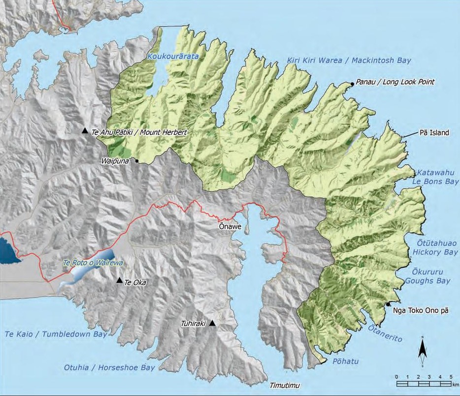
This section addresses issues of particular significance associated with with the area defined as Koukourārata to Pōhatu, and includes the eastern bays of Te Pātaka o Rākaihautū (Map 16).

The catchment of Te Ara Whānui o Makawhiua (Koukourārata) is a major focus of the section. Koukourārata is an ancient place with a long history of Ngāi Tahu settlement. Three pā once existed around the bay: Kaitara, Koukourārata, and Puāri. After the fall of Kaiapoi Pā, Koukourārata and Puāri became the main centres of Ngāi Tahu activity in the Canterbury region. Today, Koukourārata remains a place to settle, reunite and meet.

The geography of the land in this section captures the essence of the Ngāi Tahu resource management principle Ki Uta Ki Tai: from mountains to sea. Steep hills form the outer ridge line of numerous small catchments that extend into lowland valleys and open into coastal bays. Prominent ridge lines extend from summit to sea, forming isolated coastal headlands. Waterways draining the upper slopes meander through bushed stream gullies and across valley floors and into the sea, connecting hills to sea: the umbilical cord between Papatūānuku and Tangaroa.

Despite remaining relatively remote, the eastern bays landscape has experienced extensive change over time. Densely forested hills and valleys have been replaced by pastoral farmland, with a number of small coastal settlements. The protection and restoration of indigenous biodiversity has emerged as an important kaupapa, and there are numerous examples of community-led native bush protection, riparian planting, and species recovery projects in the takiwā. Working with the wider community to restore the natural and cultural heritage of Te Pātaka o Rākaihautū is an important kaupapa for tāngata whenua in the Koukourārata to Pōhatu region.

Map 16: Koukourarata

Koukourārata takiwā map

NOTE: See Section 5.1 (Issue K1 - Recognising Manawhenua) for guidance on identifying the Papatipu Rūnanga with manawhenua and kaitiaki interests in this area.

Ngā Paetae | Objectives

(1) The exercise of kaitiakitanga is enhanced through working alongside local authorities, central government, local conservation groups and the wider community to ensure the active protection of the land, water and natural resources of the catchments: mō tātou, ā, mō kā uri ā muri ake nei.
(2) Te Ara Whānui o Makawhiua is managed as a mahinga kai and matāitai, first and foremost.
(3) Indigenous biodiversity is protected and enhanced, including mahinga kai.
(4) The mauri of waterways, waipuna and wetlands is protected and restored.
(5) Management of the effects of land use, particularly run-off, on water quality and coastal water quality is improved.
(6) Ngāi Tahu cultural landscape values in the Koukourārata to Pōhatu catchments are protected and enhanced, including knowledge of, and access to, these.

Ngā Take | Issues of Significance

KP1: Effects of Land Use on Water

Issue KP1: Rural land use is having effects on waterways, marae and community drinking water supplies and coastal water quality, in particular:
(a) Contaminant run-off from rural land use;
(b) Sedimentation from forestry activities and soil erosion;
(c) Stock access to waterways;
(d) Water diversions and abstractions;
(e) Reduced catchment water yield as a result of commercial forestry plantations; and
(f) Discharges from aerial spraying, and pollen from commercial forestry, entering into rainwater tanks.

Ngā Kaupapa / Policy

KP1.1 To require that land use and management in the Koukourārata to Pōhatu catchments gives effect to the principle of Ki Uta Ki Tai, recognising the effects of land use on water. This means: (a) Recognising and providing for the relatively short distance between land use and coastal water quality, given the short and steep nature of catchments.

KP1.2 To require that local government recognise and provide for marae and community drinking water supplies as having priority over the use of water for farming activities or new development proposals by:
(a) Reviewing existing water permits and land use consents in those catchments where community water supply is currently compromised or at risk and implementing measures to protect and restore those supplies; and
(b) Assessing new land use and water permit consent applications, including tree planting consent applications, for potential effects on community drinking water supplies.

KP1.3 To require the establishment of planted (indigenous) riparian margins on all waterways from Koukourārata to Pōhatu as a means to protect mauri and water health.

KP1.4 To use native plantings to control erosion below and above roads.

He Kupu Whakamāhukihuki / Explanation

Rural land use in Koukourārata and the eastern bays is having an impact on water quantity and quality, and coastal water quality. Freshwater resources in the region are limited and can be subject to a number of competing demands from rural land use and settlements. The geography of the land means that the distance between the upper catchment and the coastal marine area is relatively short and steep, and thus the effects of land use on coastal water quality can be immediate, and significant.

An issue of particular significance is how rural land use is affecting marae and community drinking water supplies, and water quality in streams used for mahinga kai. Upstream abstractions and stock access to waterways are having adverse effects on drinking water quality and supply in some catchments, and on mahinga kai sites such as watercress and mint gathering sites and īnanga spawning areas. Discharges to air, including pollen from forestry plantations and aerial spraying as part of farming operations, can result in contaminants entering rainwater tanks. Protecting the mauri of waterways and the coastal marine area, and ensuring reliable and safe marae and community drinking water supplies must have priority over abstractive use.

"Sedimentation, and run-off from short, steep catchments are two of the main issues for Koukourārata with regard to protecting freshwater and coastal water quality."

There are a limited number of streams in catchments such as Koukourārata and these waterways are often where stock is concentrated. Stock is having detrimental effects on waterways, especially given the limited fencing of waterways and presence of riparian margins.

Cross reference:

» General policies in Section 5.3 – Issue WM3: Priorities for water use; Issue WM6: Water quality; and Issue WM7: Effects of rural land use on water
» General policy on coastal water quality (Section 5.6 Issue TAN2)

KP2: Kaimona

Issue KP2: Increasing pressure on kaimoana resources of Te Ara Whānui o Makawhiua as a result of:
(a) Discharges to the coastal marine area and harbour, and impacts on coastal water quality;
(b) Lack of compliance with mātaitai by-laws (overharvesting, poaching);
(c) Lack of awareness among visitors of the importance of the bay as mahinga kai; and
(d) Dredging in Whakaraupō and deposition of silt in Te Ara Whānui o Makawhiua.

Ngā Kaupapa / Policy

KP2.1 To manage Te Ara Whānui o Makawhiua as a mahinga kai and matāitai first and foremost, and to assess all activities for consistency with this policy.

KP2.2 To continue to implement the Port Levy/ Koukourārata Mātaitai Management Plan 2008 to conserve, manage and restore kaimoana within the Mātaitai area.

KP2.3 To require that the relationship between tāngata whenua and Te Ara Whānui o Makawhiua is recognised as an RMA s.6 (e) matter in regional coastal environment planning, including the importance of the harbour for mahinga kai.

KP2.4 To require that water quality in the harbour is such that tāngata whenua can exercise customary rights to safely harvest kaimoana.

KP2.5 To continue to work with local authorities to develop appropriate policies and rules to implement and enforce measures to improve coastal water quality, including:
(a) Fencing of waterways that flow into the harbour to prevent stock access;
(b) Establishment of riparian margins and buffers between farmland and waterways;
(c) Best practice septic tank design and maintenance, and prohibit longdrops;
(d) Stormwater discharge to land as opposed to drain outlets on the beach;
(e) Prohibiting the discharge of sewage, bilge water or rubbish from boats while in or adjacent to Te Ara Whānui o Makawhiua;
(f) Requiring that silt from dredging in Whakaraupō does not enter Te Ara Whānui o Makawhiua, and that the activity is monitored for adverse effects on the harbour; and
(g) Culling of Canadian geese populations.

KP2.6 To use rāhui as a tool to close off kaimoana beds when toxin levels exceed safe levels for human health.

KP2.7 To promote the establishment of native planted riparian margins along the coastline of Te Ara Whānui a Makawhiua, as a natural filtering system to capture run-off from land.

KP2.8 To improve compliance with mātaitai regulations through the following measures:
(a) Education of the wider community regarding the bay as mahinga kai;
(b) Continued support for tāngata tiaki to monitor the mātaitai area, including the rāhui on the beachfront cockle beds; and
(c) Investigation of establishing further limits on recreational takes in the mātaitai area.

KP2.9 To continue to initiate and support research projects on kaimoana health, abundance and diversity in the area from Koukourārata to Pōhatu.

He Kupu Whakamāhukihuki / Explanation

Te Ara Whānui o Makawhiua (Koukourārata) is a rich mahinga kai resource and management of the traditional fishery is a focal point for tāngata whenua. The health of kaimoana is integral to Ngāi Tahu culture and identity.

Increasing pressure on kaimoana resources is an ongoing management challenge for tāngata whenua. The purpose of Policies KP2.1 to KP2.8 is to address those issues that are contributing to adverse effects on the health and abundance of kaimoana resources. Central to this approach is to ensure all activities are consistent with “the Bay as a Mahinga Kai and Mātaitai”, meaning that all decisions must relate back to mahinga kai: how will the proposed activity affect mahinga kai resources and the ability of tāngata whenua to access and use these resources?

The whole of Te Ara Whānui o Makawhiua is a Mātaitai Reserve governed by the Koukourārata Mātaitai Committee (Te Rūnanga o Koukourārata and community representatives). The purpose of the mātaitai is to conserve, protect and restore kaimoana resources. Management of the reserve is driven by Ngāi Tahu tikanga and kawa (for more information on mātaitai and a map of the Koukourārata Mātaitai see Section 5.6 Issue TAN4).

Non-compliance with mātaitai regulations is an ongoing issue for tāngata whenua. Recreational fishing and the lack of awareness of visitors of the importance of the bay as a mahinga kai continue to put pressure on kaimoana resources. Supporting tāngata tiaki and educating people about mahinga kai values and mātaitai regulations are key methods to address issues such as over-harvesting and poaching.

"Kia whakakaha ai ngā putake, kia tū ai he whare whakaruruhau mō tātou ngā uri a muri ake nei – Build on the foundations of the past and present for the wellbeing of future generations."(2)

"Compliance is a big issue within our mātaitai. It is difficult because every man and his dog has a boat. We need to protect our mātaitai better and we need to educate commercial and recreational users."

Cross reference:

» Issue KP1: Effects of land use on water
» Issue KP3: Increased recreational use of the bay
» General policy on coastal water quality (Section 5.6 Issue TAN2)

KP3: Recreational use of the Harbour

Issue KP3: Increasing recreational use of Te Ara Whānui o Makawhiua is having effects on the marine environment, our sense of place and mahinga kai.

Ngā Kaupapa / Policy

KP3.1 To require watercraft activities to be consistent with ‘the Bay as mahinga kai’. This means:
(a) Speed limits (and enforcement of limits) for watercrafts that avoid adverse effects on mahinga kai;
(b) Prohibiting jet skis close to shore; and
(c) Prohibiting the discharge of sewage or bilge water in or adjacent to the harbour.

KP3.2 To support signage that identifies the importance of Te Ara Whānui o Makawhiua as mahinga kai and the desire for the community to manage recreational use.

KP3.3 To require that regional council establish ‘safety zones’ around foreshore areas that should be closed to recreational water craft.

KP3.4 Structures in the coastal marine area have the potential to affect tāngata whenua values and interests, and will be assessed on a case by case basis, considering:
(a) Purpose (e.g. private or community);
(b) Effects on mahinga kai and the matāitai reserve;
(c) Effects on the marine environment; and
(d) Cumulative effects.

He Kupu Whakamāhukihuki / Explanation

Te Ara Whānui o Makawhiua has significant recreational value for the community. The purpose of policies KP3.1 to KP3.4 is to ensure that recreational use of the bay does not compromise tāngata whenua interests in protecting the bay as a mahinga kai and matāitai, and the relationship of tāngata whenua with these ancestral waters.

Tāngata whenua have a particular interest in ensuring that structures in the coastal marine area do not adversely affect mahinga kai resources and use of the bay for mahinga kai purposes. Structures such as boat ramps, slipways and jetties can interfere with kaimoana (mussel) beds and water flow in the harbour. Limiting the number and location of structures in the coastal marine area is important to controlling recreation use of Te Ara Whānui o Makawhiua.

KP4: Subdivision and residential land development in Koukourārata

Issue KP4: Subdivision and residential land development in Koukourārata can have adverse effects on tāngata whenua values and interests, including:
(a) Remote and rural character of the settlement;
(b) Quality and quantity of freshwater resources;
(c) Coastal water quality and kaimoana; and
d) Wāhi tapu and wāhi taonga, and other cultural landscape values.

Ngā Kaupapa / Policy

KP4.1 To ensure that subdivision, development and building activity in the community of Koukourārata is consistent with:
(a) Maintaining the rural and remote character, and size, of the community;
(b) Managing Te Ara Whānui o Makawhiua as a mahinga kai and mātaitai; and
(c) Recognising and providing for Koukourātata as a Ngāi Tahu cultural landscape with significant historical, traditional, cultural and contemporary associations.

KP4.2 To advocate for the development of an Area Plan for Koukourārata to determine the appropriate level of development in and adjacent to the settlement. The Plan needs to recognise the Papatipu Rūnanga, and ensure consistency with tāngata whenua objectives for subdivision and development in the community (Policy KP4.2).

KP4.3 To assess subdivision and residential land development in Koukourārata with reference to the following ‘cultural bottom lines’:
(a) The design, scale and siting of any development (i.e. structure, dwelling, planting) must not reasonably detract from the natural landscape and character of the Koukourārata;
(b) All new residential developments must work within existing limitations on water supply, installing roof collection systems for rainwater. Streams and springs should not be relied on;
(c) The highest standard must apply to septic systems design, and there must be no discharge of wastewater to water or to land where it may enter water;
(d) Stormwater must be treated and discharged to land (cannot enter waterways or coastal waters);
(e) A percentage of the land being developed must be planted in native trees and shrubs;
(f) Street lighting is kept to a minimum to preserve value of celestial darkness and ‘small remote village feel’; and
(g) Adoption of a precautionary approach to earthworks activities and risk to sites of significance.

KP4.4
To ensure that subdivision and development activities do not encroach on Māori reserve land, including road widening and the creation of footpaths.

He Kupu Whakamāhukihuki / Explanation

Preserving the rural and remote nature of Koukourārata is important to protecting the Ngāi Tahu sense of place and the history and identity of tāngata whenua on the landscape. Any development that occurs in the community must be consistent with the existing character and sense of place and not affect tāngata whenua aspirations for land restoration or managing coastal waters as mahinga kai. A values based framework for assessing subdivision and building activities in the community enables tāngata whenua to achieve these goals. (see Box - Tāngata whenua criteria for assessing land use, subdivision and coastal land development in Koukourārata and the eastern bays).

"Sustaining what we have at home is our biggest interest."

Tāngata whenua must have a prominent and influential role in determining the nature and extent of development in the community. Lack of consultation is a matter of concern, with tāngata whenua often feeling “in the dark” about subdivision or building proposals in the community.

The preparation of an area or master plan for the community is one way to achieve this objective. An area plan enables a long-term ‘big picture’ vision for development, rather than an ad hoc approach of individual consent applications. An area plan will also enable a close evaluation of issues surrounding limited community sewage and water infrastructure, an important issue across the takiwā.

Policies KP4.1 to KP4.4 apply to the community of Koukourārata. Rural and coastal land development in the eastern bays is addressed in Issue KP5.

"Sustainable housing, low impact design and alternative energy sourcing is consistent with being Ngāi Tahu: it is who we are."

Tāngata whenua criteria for assessing land use, subdivision and coastal land development in Koukourārata and the eastern bays:

  • How will the activity affect Koukourārata as a mahinga kai and matāitai?
  • Is the allotment size, scale and nature of the development consistent with the preserving rural and remote character and sense of place?
  • Precedence – is the development setting a precedent on the landscape?
  • Ability of existing community infrastructure to accommodate growth – can existing roading, water and sewage infrastructure support the new activity and/or what level of new infrastructure is or may be required?
  • Will the activity increase pressure on freshwater resources? What is the distance to water, including coastal waters?
  • Is there an opportunity for the proposed development to enhance indigenous biodiversity values, and the presence of indigenous species on the landscape?
  • What are the potential effects on cultural landscape values, including wāhi tapu, wāhi taonga, natural landforms and features, and the cultural and physical connections between these?
  • Will the activity have implications for Ngāi Tahu access to sites of significance, or for Ngāi Tahu aspirations for the area? 
  • To what degree does the activity modify the landscape and/or what measures are proposed to enhance the landscape?

Cross reference:

» General policy subdivision and development (Section 5.4, Issue P4)
» General policy on silent files (Section 5.8, Issue CL4)

KP5: Rural and Coastal Land Development

Issue KP5: Rural and coastal land development can have effects on natural and cultural landscape values.

Ngā Kaupapa / Policy

KP5.1 Tāngata whenua will assess rural and coastal land development in the eastern bays as per general policy on Coastal land use and development (Section 5.6 Issue TAN7), with particular attention to:
(a) Protecting wāhi tapu and wāhi taonga;
(b) Avoiding incremental development and ensuring that existing modification of the landscape is not used to justify further development where such development is inappropriate;
(c) Promoting riparian margins in coastal areas;
(d) Recognising the short and steep nature of the eastern bays catchments, and therefore the relatively short distance between land use and coastal water quality; and
(e) Retaining the rural environment by maintaining small-scale land use and open space patterns in the rural zone.

He Kupu Whakamāhukihuki / Explanation

Rural and coastal land use and development can have significant adverse effects on the environment and cultural landscape values of the Koukourārata to Pōhatu catchments (see Box – Rural and coastal land development issues). The region is almost entirely designated as rural zone in the Banks Peninsula District Plan, characterised by a mix of small scale development and land use and low levels of built environment. Careful consideration is required to identify areas that are able to withstand land use intensification and change without compromising existing landscape values or future aspirations for particular areas. Open, undeveloped space is important to the relationship between Ngāi Tahu and their culture and traditions and ancestral lands and sites in the eastern bays.

A values based framework for assessing coastal land development enables tāngata whenua to encourage appropriate development while protecting cultural values. An important feature of this framework is the use of a cultural landscape approach to identify and protect cultural values and interests from the potential effects of coastal land development (see Issue KP6).

"There is a house built on the other side of the bay that was build in the last 10 years. We had no idea that the subdivided land included title right down to the water’s edge. That area is historically significant to us. We had no idea someone could buy the coast."

"All bays face the same issues with regard to sewage and reticulated water [limited services]. How will increased development affect existing infrastructure, and how will the environment accommodate new infrastructure?"

Rural and coastal land development issues

Issues of importance for tāngata whenua with regard to rural and coastal land use and development in the eastern bays include:

  • Potential for intensification of land use and effects on environment and mahinga kai, including increased run off of contaminants and sediments into the bays;

  • Potential effects on natural character and cultural landscape values of coastal environments, including pressure to exploit outstanding coastal views;

  • Limited community infrastructure. All the bays face the same issue – no sewage and no reticulated water;

  • Protection of sites of significance and the settings (cultural landscapes) that they occur from inappropriate subdivision, land use and development;

  • Earthworks (e.g. associated with building activity, construction of farm tracks), and potential effects on wāhi tapu and wāhi taonga values – known and unknown; and

  • Potential effects of land use and development on indigenous vegetation.

Cross reference:

» General policy coastal land use and development (Section 5.6, Issue TAN7)
» General policies in Section 5.4 – Issue P4: Subdivision and development; Issue P10: Earthworks; and Issue P14:Commercial forestry
» General policies in Section 5.8 – Issue CL1: Cultural landscapes; Issue CL2: Ngāi Tahu cultural mapping project; and Issue CL3: Wāhi tapu me wāhi taonga


KP6: Cultural Landscape Values

Issue KP6: Protection of cultural landscape values, including natural features and landforms, wāhi tapu, wāhi taonga and silent files.

Ngā Kaupapa / Policy

Cultural landscape approach

KP6.1 To adopt a cultural landscape approach to identify and protect wāhi tapu and wāhi taonga from the adverse effects of land use, subdivision and development in the Koukourārata to Pōhatu catchments.

KP6.2 To require that potential effects on cultural heritage values is fully and effectively assessed as part of all resource consent applications for the Koukourārata to Pōhatu catchments.

KP6. To use the methods set out in the general policy on Wāhi tapu me wāhi taonga (Section 5.8, Issue CL3) to protect sites of significance from inappropriate land use, subdivision and development.


Restoring cultural landscapes


KP6.4 To restore the values of, and cultural connections to, important cultural landscapes associated with Koukourārata, including but not limited to:
(a) Recognition of Horomaka Island as a traditional waka landing and mahinga kai;
(b) Gaining Māori reserve status for Horomaka Island, Pukerauaruhe Island and Pārakakariki (Pā Island);
(c) Re-gaining Māori ownership for the land taken from within Māori reserve 874 for a paper road (now owned by local government).
(d) Erecting a pouwhenua at Kawatea, the landing place of Moki; and
(e) Erecting tūpuna pou along the ridgeline above Kakanui.


Ingoa wāhi


KP6.5 To encourage the use of ingoa wāhi on the landscape.

He Kupu Whakamāhukihuki / Explanation


The Koukourārata to Pōhatu catchments have a long history of Māori land use and occupancy. The bays, coast and lands of this region are part of the history and identity of Ngāi Tahu and reflect the relationship between the tāngata whenua and the environment. The numerous pā sites, kāinga, mahinga kai areas, wāhi taonga and wāhi tapu sites of the northern and eastern bays of Te Pātaka o Rākaihautū hold the stories of Ngāi Tahu migration, settlement and resource use.

Given the richness of cultural and historic heritage values associated with this region, a cultural landscape approach is the most appropriate way to manage and protect significant sites. Silent files are an important indicator of cultural landscape values, and there are two silent files in this region, both in the vicinity of the community of Koukourārata and Te Ara Whānui o Makawhiua (see Appendix 6).

The extensive transfer of land from Ngāi Tahu to private land ownership following the land purchases of the 1860s creates challenges to maintaining a connection to places and sites that are an important part of tāngata whenua history. The majority of cultural heritage sites from Koukourārata to Pōhatu are on private land. One way of addressing this issue is to focus on building relationships with the wider community to work together to enable access to these sites. Another method is to promote the use of ancestral ingoa wāhi or place names on the landscape, to preserve the whakapapa, history and traditions of Ngāi Tahu.

"A lot of our taonga were buried – earthworks brings a risk of exposing these taonga."

"Place names are one with the land – they identify with the land. They connect us to our ancestors; our whakapapa. We need to keep these names, use them and pass them on to those who come after us."

Horomaka Island

Horomaka Island is a landscape of immense cultural importance (so much so that the name Horomaka is often used to describe the whole of Te Pātaka o Rākaihautū!). It is the tauranga (landing place) where the waka Makawhiua first landed at Te Pātaka o Rākaihautū, carrying Moki and leading a fleet of Ngāi Tahu waka southwards. The arrival of Moki at Horomaka marked the beginning of Ngāi Tahu settlement of the area.

The island is also known in Ngāi Tahu traditions as a breeding ground for shark and important kaimoana gathering area.

Restoring the mauri of this island is a key objective for tāngata whenua. The island is currently Department of Conservation land and there is an opportunity for the Department and tāngata whenua to work together to address management issues (i.e. removal of pine trees, erosion) and restore the mauri of the island as an outstanding cultural landscape.

“We want Horomaka Island to be a sanctuary for our taonga, our birds.”

“Horomaka Island reminds me that I am Ngāi Tahu.”

“The island disappeared from our ownership and it was never explained why.”

Source: Koukourārata IMP hui participants, 2010.

Cross reference:

» General policies in Section 5.8 – Issue CL1: Cultural landscapes; Issue CL2: Ngāi Tahu Cultural Heritage Mapping Project; Issue CL3: Wāhi tapu me wāhi taonga; Issue CL4: Silent files; and Issue CL6: Ingoa wāhi

KP7: Waipiuna

Issue KP7: Protection of waipuna as a wāhi taonga of particular importance.

Ngā Kaupapa / Policy

KP7.1 To require that waipuna from Koukourārata to Pōhatu are recognised and provided for as wāhi taonga, as per general policy on Wetlands, waipuna, and riparian margins (section 5.3 Issue WM13).

KP7.2 To identify opportunities to restore degraded waipuna.

He Kupu Whakamāhukihuki / Explanation

Waipuna were highly valued by the ancestors as the source of lowland streams and as wāhi taonga in their own right. Along with wetlands and riparian margins, waipuna should be protected as regional treasures. Waipuna are an important source of freshwater and are therefore integral to maintaining the cultural health of catchments. Some waipuna are considered wāhi tapu.

It is critical that waipuna associated with Koukourārata and the eastern bay catchments are protected and restored as part of maintaining and enhancing the cultural health of the takiwā.

Cross reference:

» General policy on wetlands, waipuna and riparian margins (Section 5.3, Issue WM13)

KP8: Indigenous Biodiversity

Issue KP8: Degradation and widespread loss of indigenous biodiversity and implications for the health of land, water and communities, including but not limited to:
(a) Loss of mahinga kai resources and opportunities; and
(b) Effects on the relationship of tāngata whenua with taonga species.

Ngā Kaupapa / Policy

KP8.1 To support and initiate protection, enhancement and restoration activities for the following sites and species as a matter of priority:
(a) Te Ara Whānui o Makawhiua as a mahinga kai;
(b) Owhetoro, Te Kaawa and Kokaihope streams in Koukourārata;
(c) All waterways in the region;
(d) Kahukunu Stream and Koukourārata Stream (e.g. riparian planting);
(e) Koukourārata Dry Forest;
(f) Horomaka Island, Pukerauaruhe Island and Pārakakariki (Pā Island);
(g) Kawatea (at Ōkeina);
(h) Kakanui (e.g. restoration of indigenous ecosystems on Māori reserve land);
(i) Tītī habitat at Stoney Bay - Puketi and Baleine Point;
(j) White-flippered penguin nesting area at Pōhatu;
(k) Habitat for kēreru and tui; and
(l) Coastal restoration planting and dune restoration at Ōkeina (Okains Bay).

KP8.2 To showcase existing restored areas, such as Koukourārata Stream, as examples of how good management and restoration can achieve indigenous biodiversity objectives.

KP8.3 To actively develop and maintain relationships with the wider community to restore the natural and cultural heritage of Te Pātaka o Rākaihautū.

He Kupu Whakamāhukihuki / Explanation

The widespread loss of indigenous ecosystems and biodiversity from Koukourārata to Pōhatu is an issue of immense importance for tāngata whenua. Once an area largely covered in native forest, Te Pātaka o Rākaihautū has experienced an enormous loss of the extent and quality of its indigenous biodiversity following European contact, particularly native forest cover. (see Figure on Native Forest Cover Change - Te Pātaka o Rākaihautū, in Section 5.5).

Tāngata whenua are committed to restoration projects in the eastern bays, from riparian planting on individual waterways to larger scale restoration projects on Māori reserve land. Working together with the community and external agencies with interests in biodiversity management is critical to the success of these projects. There are number of sites and species that are identified as priority for protection and/or restoration (Policy KP8.1). One of these is the upper valley dry forest area of Koukourārata, identified as one of the best examples of steep, semi-arid shrubland, grassland bluffs and dry forest on Te Pātaka o Rākaihautū.3 Importantly, the restoration of indigenous biodiversity is tied to tāngata whenua aspirations to re-establish customary use opportunities on the landscape.

"Future opportunities for customary harvest are an important consideration in restoration planning, consistent with the philosophy of mō tātou, ā, mō kā uri ā muri ake nei."

Cross reference:

» General policies in Section 5.5 – Issue TM2: Indigenous biodiversity; and Issue TM3: Restoration of indigenous biodiversity

KP9: Aquaculture

Issue KP9: Papatipu Rūnanga have rights and interests in where and how aquaculture occurs.

Ngā Kaupapa / Policy

KP9.1 To require that Papatipu Rūnanga have an explicit and influential role in decision-making regarding the allocation and use of coastal space for aquaculture, as per general policy on Aquaculture (Section 5.6, Policies TAN10.1 and TAN10.2)

KP9.2 Tāngata whenua have intent to further develop aquaculture opportunities in the Koukourārata to Pōhatu region.

He Kupu Whakamāhukihuki / Explanation

Aquaculture is the practice of farming in the water: cultivating kaimoana in marine spaces. There are several marine farms in the region, including two mussel farms at Koukourārata, one in Pigeon Bay and another in Menzies Bay.

Aquaculture is not new for Ngāi Tahu. Shellfish seeding is a traditional form of aquaculture still practiced today. Historically, tāngata whenua living at Koukourārata would travel to a neighbouring bay in the autumn, make up small beds of shellfish and store them under piles of rocks for the winter (4). These storage pits are known as taiki.

The purpose of policies KP9.1 and KP9.2 is to ensure that Papatipu Rūnanga have a say in how and where aquaculture occurs, and are able to establish aquaculture in their takiwā to provide cultural and community opportunities.

Cross reference:

» General policy on Aquaculture (Section 5.6, Issue TAN10)

END NOTES / REFERENCES

  1. Te Rūnanga o Koukourārata. Hei iti, He Pounamu (DVD).
  2. Port Levy/Koukourārata Mātaitai Management Plan 2008.
  3. Christchurch Biodiversity Strategy, p. 29.
  4. Tau, TM., Goodall, A., Palmer, D. and Tau, R. 1990. Te Whakatau Kaupapa: Ngāi Tahu Resource Management Strategy for the Canterbury Region. Aoraki Press: Wellington, p. 4-19.