IMP: Ngā Take ā-hikawai Me Ngā Kaupapa | Catchments

6.2 Waipara and Kōwai

Wāhi Tuaono | Part 6

6.2 Waipara and Kōwai [WK]

"There is not enough water in the Waipara or Kōwai Rivers to sustain cultural values."

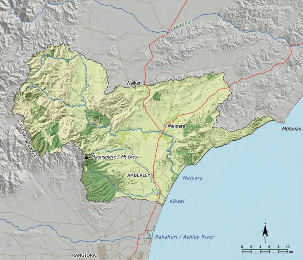
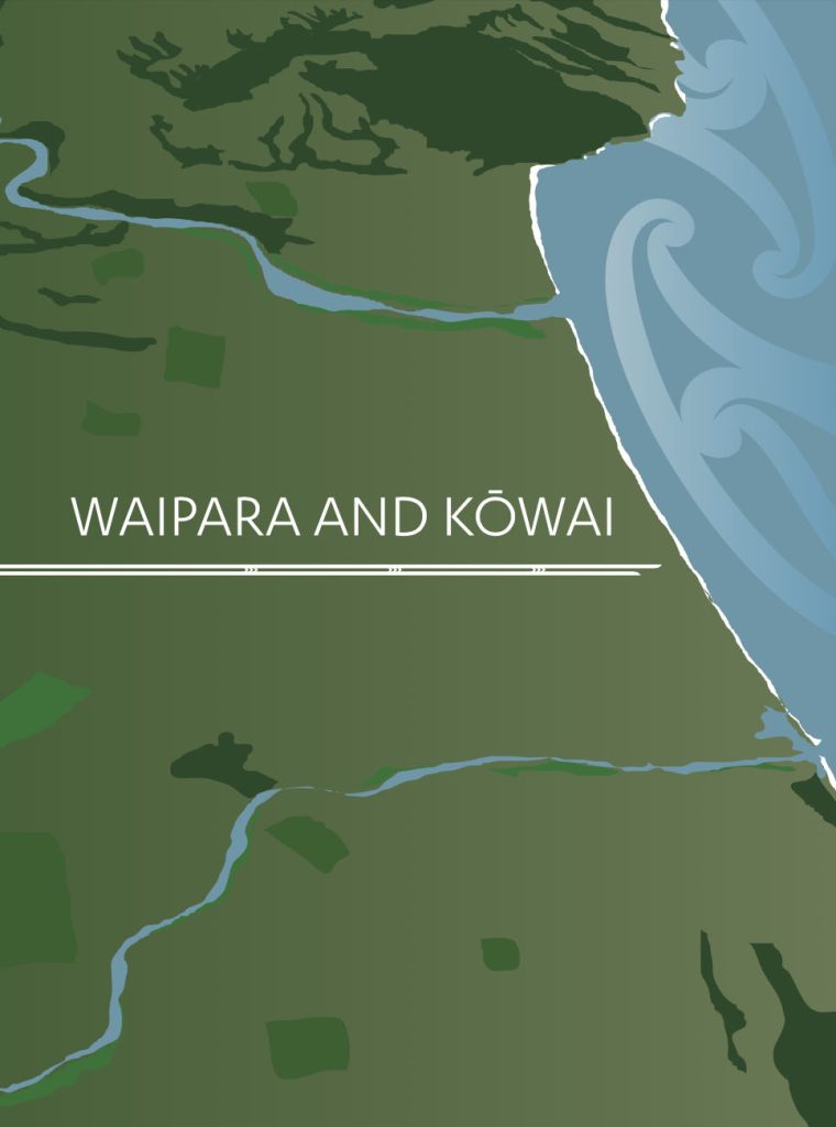
This section address issues of particular significance in the Waipara and Kōwai river catchments (Map 8).

The Waipara, named with reference to a fish caught in the river, is a rain fed river flowing from the eastern foothills of Ngā Tiritiri o Te Moana to the Waipara lagoon. The Kōwai, named after the native tree Sophora microphylla, drains a small catchment west of Amberley.  Both rivers flow into coastal lagoons and meet alongside Amberley Beach. They are considered together in this IMP due to the immense significance of the coastal area between them as one large mahinga kai resource. 

For tāngata whenua, the current state of cultural health of the Waipara and Kōwai catchments is evidence that water management and governance in the region has failed to have particular regard for kaitiakitanga, and to recognise and provide for the relationship of Ngāi Tahu with these waterways as a matter of national importance. Surface and groundwater resources are over-allocated (Issue WK2) and water quality is degraded as a result of inappropriate rural land use (Issue WK3). This has significant adverse effects on Ngāi Tahu values and interests, particularly mauri, natural character, mahinga kai, indigenous biodiversity and the hāpua where the Waipara and Kōwai rivers meet the sea.

Map 8: Waipara and Kōwai catchments

NOTE: See Section 5.1 (Issue K1 - Recognising Manawhenua) for guidance on identifying the Papatipu Rūnanga with manawhenua and kaitiaki interests in this area.

Ngā Paetae | Objectives

(1) The mauri and mahinga kai values of the Waipara and Kōwai rivers, and their tributaries, wetlands and hāpua are protected and restored, mō tātou, ā, mō kā uri ā muri ake nei.
(2) Immediate and effective measures are implemented to address over allocation of freshwater resources in the Waipara catchment.
(3) Groundwater and surface water quality in the catchments is restored to a level suitable to provide a safe, reliable, and untreated drinking water supply and enable cultural, customary and recreational use.
(4) Land use in the catchments reflects land capability and water limits, boundaries and availability.
(5) Ngāi Tahu cultural landscapes values associated with the Waipara and Kōwai rivers are protected and enhanced.

Ngā Take | Issues of Significance

WK1: Managing Intensive Land Use

Issue WK1: The assimilative capacity of the land, and water availability, limits and boundaries are being exceeded by some land use activities in the catchments.

Ngā Kaupapa / Policy

WK1.1 To continue to advocate for a rural land and water management approach that ‘matches land use with catchment water availability and limits’ and provides for the assimilative capacity of catchments, as per General Policies on Effects of rural land use on water (Section 5.3 Issue WM7) and Intensive rural land use (Section 5.4 Issue P2).

He Kupu Whakamāhukihuki / Explanation

Matching land use with natural resource capacity and limits is an important component of Ki Uta Ki Tai management, and a kaupapa for tāngata whenua in the Waipara and Kōwai catchments. The kaupapa requires that land use activities reflect local soil and climate conditions, and recognise the limits and availability of freshwater resources in catchments, rather than considering catchments in terms of potential irrigable land.

"You can grow grass anywhere if you add enough water, but we need to consider whether it is the best place to grow grass if we have to add that much water."

Cross reference:

» General policy on Papatūānuku (Section 5.4, Issue P1)
» General policy on the effects of rural land use on water(Section 5.3 Issue WM7)

WK2: Over-allocation

Issue WK2: Over-allocation of water in the Waipara and Kōwai catchments has resulted in significant effects on values of importance, including but not limited to:
(a) Mauri of surface and groundwater;
(b) Mahinga kai and customary use;
(c) Natural variability and character of the river, including floods and freshes;
(d) Cultural health of hāpua, including duration and frequency of openings;
(e) Indigenous biodiversity; and
(f) Connections of the rivers to the sea (Ki Uta Ki Tai).

Ngā Kaupapa / Policy

WK2.1 To require immediate and effective measures and timeframes to address over-allocation and restore water flows and levels necessary to sustain mauri, ecological health and Ngāi Tahu customary use in the catchments including but not limited to:
(a) A comprehensive review of water consents for the Waipara and Kōwai catchments;
(b) No further allocations of river water, or hydraulically connected groundwater until the rivers’ condition improves (and reducing the volume of existing abstraction consents if required); and
(c) Reduce abstractions on the Omihi Stream and Home Creek as a priority, as spring fed tributaries that significantly contribute to water flow in the lower Waipara.

WK2.2 To recognise and provide for the Waipara and Kōwai river catchments as ‘naturally dry’ rather than ‘water short’ or ‘water sensitive’, and plan land use activities and water management regimes accordingly.

WK2.3 Water enhancement schemes are not a solution to water quantity issues in the Waipara and Kōwai catchments.

WK2.4 To require that environmental flow and water allocation plans for the Waipara and Kōwai Rivers recognise and provide for mauri and customary use as first order priorities, and deliver cultural outcomes, as per general policy on Water quantity (Section 5.3, Issue WM8).

WK2.5 To require controls on land use, through policies and rules in district and regional plans, to protect surface water flows and groundwater recharge, as per general policy on Water quantity (Section 5.3 Issue WM8).

He Kupu Whakamāhukihuki / Explanation

Over-allocation of water in the Waipara and Kōwai catchments due to irrigation demand is a significant issue for tāngata whenua. Both rivers are in a degraded state of cultural and ecological health. The lack of water and natural variability of flow, combined with degraded water quality due to inappropriate land use activity (see Issue WK3) has resulted in significant effects on river health.

"The availability of clean fresh water in the Waipara River is essential to protecting Ngāi Tūāhuriri’s mahinga kai values." (2)

Of particular concern is the cultural health of the immensely significant hāpua located where the Waipara and Kōwai rivers meet the sea. Low flows exacerbate the ‘drying out’ of the lower reaches of the rivers over summer, hindering upstream fish passage.

"The longfin tuna get locked in at the top of the river because it is dry. You get a flush of rain and there are hundreds of tuna waiting to get out to the sea."

Water management frameworks for the Waipara and Kōwai rivers have failed to protect the mauri of these rivers, and to sustain their potential for future generations. They have also failed to recognise and provide for the relationship of Ngāi Tahu and their culture and traditions with these ancestral waters, as a matter of national importance. Resolving the issue of over-allocation requires a fundamental shift of mindset: from maintaining reliability of supply for abstractors to restoring river health. The existing volume of water abstracted from the Waipara and Kōwai river catchments must be reduced as a matter for priority, and effective and appropriate flow regimes developed that prioritise river health.

"We must begin to think about the long term health of our waterways and recognise that healthy water leads to healthy land, food and people.”

Cross reference:

» General policy on water quantity (Section 5.3 Issue WM8)

WK3: Water Quality

Issue WK3: The effects of rural land use on water quality and the cultural health of the Waipara and Kōwai rivers, their tributaries in particular:
(a) Surface run-off of sediment, nutrient and other contaminants from pastoral grazing, plantation forestry, horticulture and viticulture land use;
(b) Nutrient leaching into groundwater;
(c) Stock access to waterways;
(d) Drainage of wetlands;
(e) Degradation of riparian areas, and loss of function in maintaining water quality;
(f) Low flows due to water abstractions; and
(g) Surface run off of excess irrigation waters.

Ngā Kaupapa / Policy

WK3.1 To address water quality issues in the Waipara and Kōwai catchments with reference to general policy on Water quality (Section 5.3 Issue WM6).

WK3.2 To recognise poor water quality in the Waipara and Kōwai rivers as a result of rural land use is having an effect on coastal rocky reef habitat, and Ngāi Tahu aspirations for mahinga kai restoration.

He Kupu Whakamāhukihuki / Explanation

The degradation of the cultural health of waterways and the contamination of groundwater as a result of rural land use is a significant issue in the Waipara and Kōwai catchments. The effect of diffuse and point source pollution on water quality is compounded by low flows in waterways (see Issue WK2) and the degradation of wetlands and riparian margins that once provided buffers and filtering roles (see Box - The combined effect of low flows and contaminated run-off on water quality).

Further intensification of land use, particularly pastoral farming, viticulture and horticulture in lower catchment areas and forestry activities in upper catchment areas, is a concern given the potential for further impacts on water quality. Intensive pastoral grazing, cropping, horticulture and viticulture have the potential to degrade water quality due to sedimentation, nutrient run-off and nitrate leaching into groundwater. Plantation forestry can result in sediments and nutrients entering waterways, particularly when there is an absence of riparian buffers between the plantation and a waterway (this is an issue particularly in the Kōwai catchment).

The combined effect of low flows and contaminated run-off on water quality

The combined effect of low flows and contaminated run-off is a significant resource management issue in the Waipara and Kōwai catchments. The concern for tāngata whenua is not just the volume of water leaving the rivers, but also the quality of the water that is returning to the river through run-off and irrigation bywash, which is often contaminated with nutrients, sediment and animal effluent. We must seriously consider the sustainability of the kinds of land use that water resources are supporting and the assimilative capacity of the catchments.

WK4: Mahinga Kai

Issue WK4: Inability to harvest mahinga kai from the Waipara and Kōwai catchments, particularly the coastal areas, as a result of:
(a) Loss of or poor physical access to mahinga kai areas;
(b) Impacts of rural land use on coastal water quality and coastal rocky reef habitat;
(c) Poor cultural health of traditional mahinga kai sites;
(d) Decline in species health, abundance and diversity; and
(e) Effects of low flows and altered flow regime on fish passage.

Ngā Kaupapa / Policy

WK4.1 To address the loss of mahinga kai resources and opportunities in the Waipara and Kōwai catchments with reference to general policy on Mahinga Kai (Section 5.5 Issue TM1).

WK4.2 To restore the health of, and physical access to, the following mahinga kai sites and places within the Waipara and Kōwai catchments as a matter of priority: (a) Waipara and Kōwai river mouths; (b) Waipara coastal lagoon (hāpua); (c) Waipara rocks (access); (d) Willow removal along waterways (due to effects on mahinga kai); and (e) Coastal wetlands associated with the Kōwai river.

Nohoanga

WK4.3 To ensure that land use and water management in the Waipara catchment does not compromise the ability of Ngāi Tahu to use and develop Nohoanga sites associated with the Waipara and Kōwai catchments, statutorily recognised by NTCSA and otherwise.

WK4.4 To work with Te Rūnanga o Ngāi Tahu to address issues associated with nohoanga in the Waipara and Kōwai catchments, including: (a) Limits on ability of tāngata whenua to use the Waipara Township nohoanga (Schedule 95, NTCSA 1998) given its location (i.e. next to pub) and lack of access to water; and (b) Providing statutory identification and protection to nohoanga that are not currently recognised by the NTCSA 1998, including Waipara Rocks.


Access

WK4.5 Tāngata whenua must have access to customary mahinga kai sites and resources in the coastal area of the Waipara and Kōwai catchments.

WK4.6 To ensure that existing and future ecological and natural area significance designations complement and not restrict Ngāi Tahu customary use.


Wetlands and remnant forest areas

WK4.7 To require the protection, enhancement and extension of existing remnant wetlands and native forest areas in the Waipara and Kōwai catchments, as key mahinga kai habitats.

He Kupu Whakamāhukihuki / Explanation

The Waipara and Kōwai rivers have strong mahinga kai associations. Both rivers were once integral to the economic, cultural and social well being of Ngāi Tahu, particularly the hāpua and coastal areas. The importance of these rivers as mahinga kai is confirmed in the NTCSA 1998 (Schedules 74 and 26; see Appendix 7), and in the two nohoanga entitlements on the Waipara River. Mahinga kai activities are an important expression of cultural identity, and the continuation of traditional mahinga kai practices is a means of passing values and knowledge on to current and future generations.

As with other river catchments in Canterbury, poor water quality, low flows, drainage of wetlands, habitat loss, loss of physical access and decline in the diversity health and abundance of mahinga kai species has greatly affected the ability of tāngata whenua to engage in mahinga kai activities in the Waipara and Kōwai catchments. However, while the ability of tāngata whenua to use the rivers as mahinga kai has been severely compromised, the importance of the rivers remains, and whānau continue to direct their efforts towards restoring the rivers and the mahinga kai traditions associated with them.

The loss of physical access has added to the loss mahinga kai values in these catchments. For example, most of the land adjoining the mainstem of the Waipara River is privately owned, creating barriers to access traditional mahinga kai sites. Coastal protection areas between the Waipara and Rakahuri rivers also contribute to tāngata whenua feeling ‘locked out’ from customary use sites. Further, the nohoanga site at the Waipara Township, established under the NTCSA 1998, is limited in its ability to provide access to mahinga kai resources as it doesn’t have access to water.

"We need full and total access: we don’t want to be restricted to a small area just to fish. It is about understanding the whole environment and respecting it as a whole. We want to take our tamariki and our kaumatua to the sea and allow them to have that relationship with unimpeded access, without restriction."

Cross reference:

» General policy on access to coastal areas (Section 5.6 Issue TAN8)

WK5: Hāpua

Issue WK5: Degradation of the Waipara and Kōwai hāpua as a result of:
(a) Inappropriate land use activities that contribute to poor water quality; and
(b) Low flows in the rivers as a result of inappropriate environmental flow regimes and water allocation models.

Ngā Kaupapa / Policy

WK5.1 To recognise, provide for and manage the coastal environment associated with the area between the Waipara and Kōwai rivers as a cultural landscape with significant cultural heritage and mahinga kai values.

WK5.2 To avoid any further loss of ecosystem and mahinga kai values associated with the Waipara and Kōwai river mouth environments and hāpua, as a matter of priority. This means:
(a) Recognition of immense importance of these areas to Ngāi Tahu;
(b) Effective measures to address water quality and quantity issues (see Issues WK2 and WK3);
(c) Restoration programmes for habitat and species; and
(d) Appropriate management of public access and use.

WK5.3 Environmental flow and water allocation regimes for the Waipara and Kōwai rivers must recognise and provide for the relationship between river flow, water quality and hāpua, including ensuring sufficient flow, floods and freshes to enable an open river mouth at appropriate times of year for the recruitment of mahinga kai species, particularly tuna and īnanga.

WK5.4 To require the monitoring of cultural health and water quality at the hāpua / river mouth of the Waipara and Kōwai rivers as a measure of overall catchment health of the effects of land use on the health of the river.

He Kupu Whakamāhukihuki / Explanation

The coastline between the Waipara and Kōwai rivers, including the coastal wetlands and hāpua at the mouth of each river, holds strong mahinga kai and wāhi tapu associations for tāngata whenua. While the ability of tāngata whenua to engage in mahinga kai activities has been compromised over time by the loss and of mahinga kai resources and opportunities (Issue WK4), the significance of the hāpua has not diminished.

Water quality in coastal hāpua reflect land and water use and management in the catchment. These environments make ideal monitoring sites to assess our progress toward meeting water quality objectives and standards.

Cross reference:

» General policy on hāpua (Section 5.6 TAN3)

WK6: Gravel Extraction

Issue WK6: Gravel extraction in the Waipara and Kōwai riverbeds can have effects on mauri, hāpua, water quality and mahinga kai.

Ngā Kaupapa / Policy

WK6.1 To support sustainable gravel extraction in the Waipara and Kōwai catchments while ensuring the protection of environmental and cultural values, in accordance with general policy on Activities in the beds and margins of rivers (Section 5.3 Issue WM11).

WK6.2 To advocate that district and regional councils implement a monitoring programme for gravel extraction on the Waipara River, to assess effects of gravel extraction on the river environment.

He Kupu Whakamāhukihuki / Explanation

Gravel extraction is a necessary feature of floodplain and river management as the build up of gravels can create flood risks. However, uncontrolled gravel extraction can have adverse effects on the river environment and tāngata whenua values, including changing the natural character of the waterway, disrupting mahinga kai habitat and creating sedimentation and water quality issues. The current rate of gravel extraction from the Waipara River is described as “well in excess of what can be sustainably taken without lowering the river bed levels”.(3)

Cross reference:

» General policy on activities in the beds and margins of rivers (Section 5.3 Issue WM12)

WK7: Willows in Riverbeds & Margins

Issue WK7: The spread of willow and along the Waipara and Kōwai rivers has a significant effect on tāngata whenua values and the river environment.

Ngā Kaupapa / Policy

WK7.1 To require the removal of willow from the beds and margins of the Waipara and Kōwai Rivers, and planting of these areas in native riparian species (appropriate to that particular place), in particular: (a) The Waipara riverbed below the State Highway 1 Bridge, to restore the open riverbed habitat for bird life and lagoon areas for fish habitat.

WK7.2 Where river rating districts are established to contribute to the costs of clearing and maintaining willows along rivers for flood protection (e.g. North Branch Kōwai), such schemes should also include provisions for: (a) Planting of native riparian plants where willows are removed, to further the flood protection goals and enhance natural and cultural landscape values.

WK7.3 To require that environmental flow regimes allow for an increase in the size, duration and frequency of natural flood flows, as a means to avoid the establishment of willow, and other weeds, in the Waipara and Kōwai River beds.

He Kupu Whakamāhukihuki / Explanation

Willows (predominately crack, but also grey) are well established along many areas of the Waipara and Kōwai rivers and have a significant effect on natural character and river health by disrupting, confining and reducing flow, and reducing native biodiversity. One study found that in many places on the Waipara River the width of the channel has been reduced by 50-70% during the last 50 years.(4)

Tāngata whenua recognise that willows were established in rivers for bank stabilization purposes. However native riparian plant species are better suited to bank stabilization and can provide flood control, without the adverse effects associated with willows. A comprehensive strategy to enable the removal and eradication of willow species in the Waipara and Kōwai catchments will achieve multiple environmental and cultural benefits.

WK8: Viticulture

Issue WK8: Viticulture activities are important to the region but can have adverse effects on the land and water values.

Ngā Kaupapa / Policy

WK8.1 To encourage the adoption of sustainable management practices that minimise impacts of vineyards on the environment, including organic operations, sustainable site selection and efficiency measures.

WK8.2 To require substantial set back areas or buffer zones from any waterway, bore, wetland or spring, to prevent adverse impacts on soil and water resources.

He Kupu Whakamāhukihuki / Explanation

Viticulture is a prominent land use activity in the Waipara and Kōwai catchments. As a highly intensive land use activity using a relatively small land area, viticulture has the potential to affect water and soil resources. For example, water takes associated with vineyards are not usually standard water takes; usage is seasonally, and even grape variety, dependent, and can be characterised by dramatic spikes and strong lows off-season. Weed control, pesticide use, soil erosion, run-off and water abstractions are additional issues of concern when assessing applications for new vineyards.

WK9: Wāhi Tapu me Wāhi Taonga

Issue WK9: Protection of wāhi tapu and wāhi taonga values in the Waipara and Kōwai catchments, in particular:
(a) Wāhi tapu and wāhi taonga at the Waipara river mouth and along the coast;
(b) Rock art sites in inland areas of the Waipara catchment; and
(c) Unknown archaeological sites.

Ngā Kaupapa / Policy

WK9.1 To recognise and provide for the Waipara and Kōwai catchments as cultural landscapes with significant historical, traditional, cultural and contemporary associations.

WK9.2 To recognise and provide for the following Deed of Settlement/NTCSA 1998 provisions as cultural landscape indicators (see Appendix 1):
(a) Statutory Acknowledgements for Waipara and Kōwai Rivers;
(b) Use of the ancestral name Maukatere alongside Mount Grey; and
(c) Nohoanga entitlements.


Wāhi tapu me wāhi taonga


WK9.3 To require that activities associated with the river mouths and coastal environment of the Waipara and Kōwai rivers do not adversely affect the wāhi tapu and wāhi taonga values associated with that environment.

WK9.4 To require appropriate policies, rules and methods in district and regional plans to protect wāhi tapuand wāhi taonga from inappropriate land use and development, in accordance with general policy on Wāhi tapu and wāhi taonga (Section 5.8 Issue CL3).


Rock art

WK9.5 To support the work of the Ngāi Tahu Māori Rock Art Trust in preserving and protecting rock art in the Waipara catchment.

WK9.6 To require the recognition of Papatipu Rūnanga with regard to the protection and management of rock art sites.

He Kupu Whakamāhukihuki / Explanation

There are numerous wāhi tapu and wāhi taonga in the Waipara and Kōwai catchments, including a high concentration of registered archaeological sites along the coast between the Kōwai and Waipara rivers, the Waipara river mouth and inland Waipara. There is extensive evidence of occupation of Waipara river mouth. The site is identified as a moa hunter occupation site, and includes pā sites, and midden, pits, ovens and cave shelters.(5)

Weka Pass is a well-known rock art site. Ngāi Tahu tūpuna drew on the walls of rock shelters with charcoal and red ochre (kōkōwai). While the most obvious and visible art in the Weka Pass shelters were over painted or ‘freshened” in the 1930s to make them more visible to tourists, approximately 100 figures remain in their natural state, still visible amongst the retouched art.(6)

Cross reference:

» General policies in Section 5.8 – Issue CL1: Cultural landscapes; Issue CL2: Ngāi Tahu cultural heritage mapping; and Issue CL3: Wāhi tapu and wāhi taonga

Information resources:

»  Zygadlo-Kanara, F. & Te Rūnanga o Ngāi Tūāhuriri, 2004. Waipara Catchment: Tāngata Whenua Values. Environment Canterbury Report R04/01.

»  Jolly, D. on behalf of Te Rūnanga o Kaikoura and Ngāi Tūāhuriri Rūnanga, 2004. Tāngata Whenua Values Report for the Waiau, Hurunui, Waipara and Kōwai river catchments, as part of the Hurunui Community Water Development Project.

END NOTES / REFERENCES

  1. Tau, TM., Goodall, A., Palmer, D. and Tau, R. 1990. Te Whakatau Kaupapa: Ngāi Tahu Resource Management Strategy for the Canterbury Region. Aoraki Press: Wellington, p. 5-12.
  2. Zygadlo-Kanara, F. & Te Rūnanga o Ngāi Tūāhuriri, 2004. Waipara River Tangata Whenua values Report. Environment Canterbury Report R04/01, p.10.
  3. Environment Canterbury, 2010. Draft Waipara River Management Strategy, p.19.
  4. Mosely, M. P., 2003. Waipara River: Instream values and flow regime. Report R03/1 Environment Canterbury.
  5. NTCSA 1998; Tau, TM., et al. 1990; Zygadlo-Kanara, F., et al. 2004.
  6. http://www.ngaitahu.iwi.nz/RockArt