IMP: Ngā Take ā-hikawai Me Ngā Kaupapa | Catchments

6.5 Ihutai

Wāhi Tuaono | Part 6

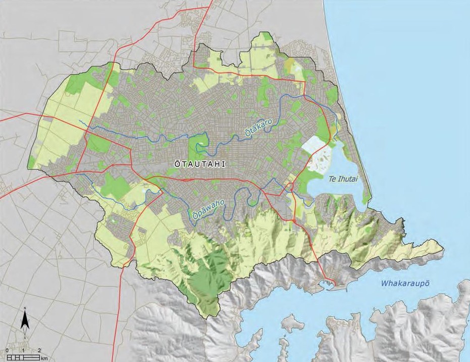
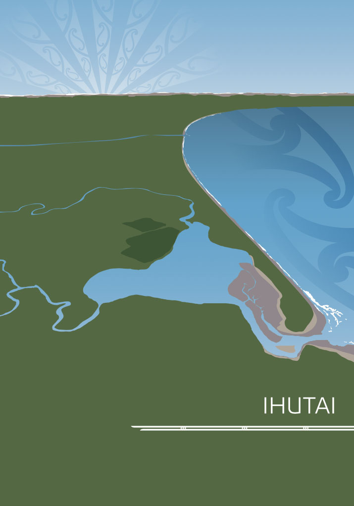
This section addresses issues of particular significance associated with the Ihutai catchment. The catchment area includes the Ōtakaro and Ōpāwaho rivers, and Te Ihutai (the estuary), and generally follows the boundaries of the urban environment of Ōtautahi (Map 12).

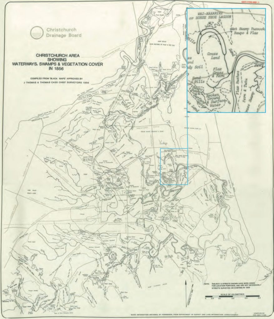
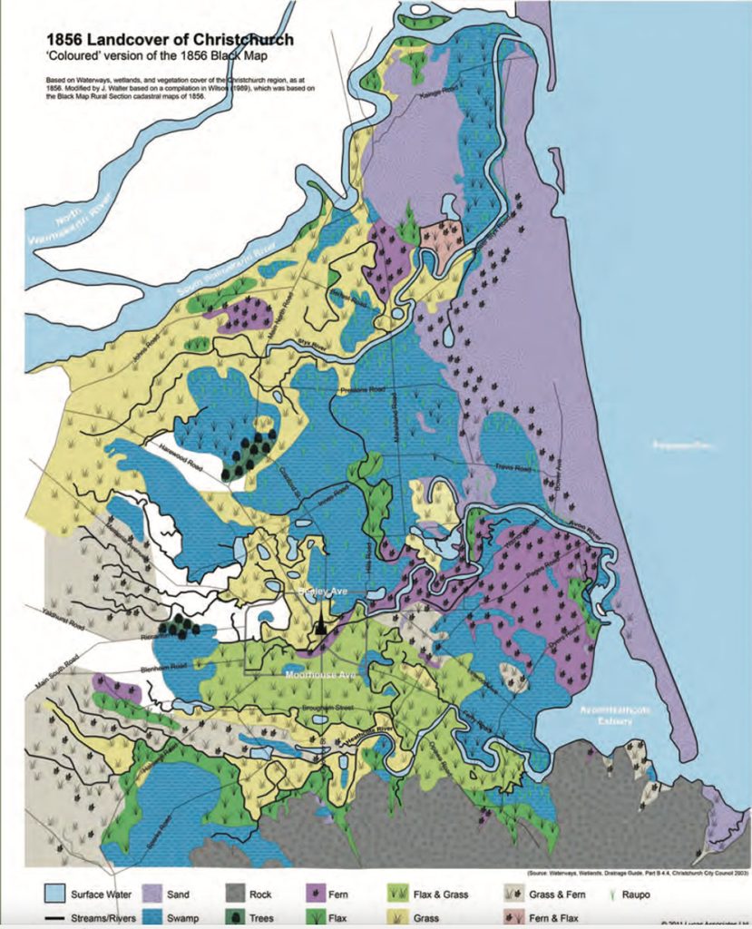
The Ihutai catchment is an area of immense cultural and historical importance to tāngata whenua. The area was a place of significant settlement and food gathering for Waitaha, Ngāti Mamoe and Ngāi Tahu for over 600 years. While the estuary itself provided an abundance of valuable food resources, equally important was the estuary’s catchment, which was made up of an extensive network of springs, waterways, swamps, grasslands and lowland podocarp forests.

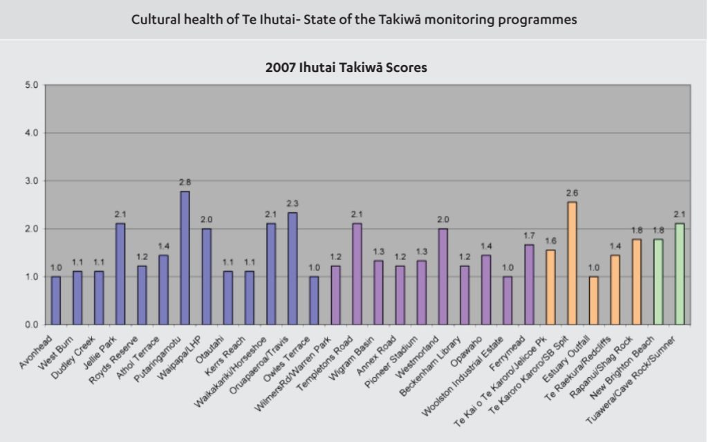
The effect of the city’s historical and ongoing urban development on Ngāi Tahu cultural values is a key kaupapa underlying issues and policies in this section. The catchment is a highly modified environment that has undergone dramatic change in the last 160 years, particularly with regard to the loss of mahinga kai, natural areas and indigenous habitats and ecosystems, and the decline of water quality. Ngāi Tahu cultural health assessments undertaken in 2007 and 2012 found the catchments are generally in a poor state of cultural health, based on cultural health assessment factors such as suitability of harvesting mahinga kai, water quality, physical and legal access, degree of external pressure on site, degree of modification, and the presence and abundance of native fish, bird and plants species, as well as introduced species (see Figure 1).

The rebuild and redevelopment of Ōtautahi provides a unique opportunity to re-establish a strong and visible indigenous presence on the city landscape (Issue IH1), enhancing a sense of identity and belonging for Ngāi Tahu in the city.

Map 12: Ihutai Catchment

NOTE: See Section 5.1 (Issue K1 - Recognising Manawhenua) for guidance on identifying the Papatipu Rūnanga with manawhenua and kaitiaki interests in this area.

Figure 1

Ihutai takawa scores

2007 Results: Of the 30 sites assessed in 2007, 64% were found to be of poor health, with a further 13% rated as very poor. No sites were rated as good or very good; however 23% of the sites were rated as moderate.

2012 Results: Of the 31 sites assessed in 2012, 13% of sites were rated as very poor, with 39% rated as poor, and a further 48% scoring as moderate in terms of overall cultural health.

These results indicate that the cultural health of the catchment in 2012 is similar to that recorded in the 2007; however modest improvements in the cultural health of some sites are apparent. A comparison of Takiwā 2.0 Overall Site Health scores shows that 16 sites have improved and 10 sites have deteriorated with four sites returning the same score. Improvements were most notable at sites where riparian restoration actions have occurred such as at the Beckenham Library and Ōpāwaho sites.

Source: State of the Takiwā 2007 – Te Āhuatanga o Te Ihutai (Pauling et al. 2007); State of the Takiwā 2012 – Te Āhuatanga o Te Ihutai (Lang et al., 2012).

Ngā Paetae | Objectives

(1) Ngāi Tahu have a prominent and influential role in the rebuild and redevelopment of Ōtautahi, postearthquake.
(2) Ngāi Tahu has a more visible cultural presence in the urban environment, both on the physical landscape and in city planning and decision making processes.
(3) Ngāi Tahu sense of place and identity is enhanced through the restoration of the cultural health of the Ihutai catchment.
(4) Discharges of wastewater and stormwater to waterways in the urban environment are eliminated, and a culturally appropriate alternative to the discharge of urban wastewater to the sea is developed.
(5) Mahinga kai values and associations with the Ihutai catchment are re-established, alongside the urban built environment.
(6) The restoration and enhancement of indigenous biodiversity is an essential part of the image and brand of Ōtautahi, and an improved balance between exotic and indigenous plant species is achieved.
(7) Urban development reflects low impact urban design principles and a strong commitment to sustainability, creativity and innovation with regard to water, waste and energy issues.
(8) Wāhi tapu and wāhi taonga values are protected from inappropriate urban development.

Ngā Take | Issues of Significance

IH1: Ngāi Tahu and the Urban Environment

Issue IH1: Ngāi Tahu have a key role to play in planning and managing the urban environment, as tāngata whenua and Treaty partner.

Ngā Kaupapa / Policy


Rebuild of Ōtautahi

IH1.1 To ensure that Ngāi Tahu maintains a prominent and influential role in the re-build of Ōtautahi postearthquake, with specific focus on achieving tāngata whenua aspirations for:
(a) Ngāi Tahu culture and identity as a unique aspect and asset of Ōtautahi;
(b) A more visible cultural presence in the urban environment, and respect for shared cultural and natural heritage of the city;
(c) Designing the urban environment in a way that respects the wāhi taonga status of the Ōtakaro and Ōpāwaho rivers, and ensures that urban development works with these wai tūpuna rather than against them;
(d) Protection and enhancement of cultural landscape values in the urban environment, particularly indigenous biodiversity;
(e) Improving the cultural health of waterways and drains;
(f) Protection of waipuna;
(g) Protection of wāhi tapu and wāhi taonga from inappropriate land use and development;
(h) General ‘greening’ of the city through low impact urban design and a strong sustainability focus on the redevelopment of residential, public and commercial spaces; and
(i) Improved stormwater and wastewater management and infrastructure, reflecting Ngāi Tahu values and tikanga.


Participation in urban planning

IH1.2 To require early, appropriate and effective involvement of Papatipu Rūnanga in the development and implementation of urban development plans and strategies, including but not limited to:
(a) Urban development strategies;
(b) Plan changes and Outline Development Plans;
(c) Area plans;
(d) Urban planning guides, including landscape plans, design guides and sustainable building guides;
(e) Integrated catchment management plans (ICMP);
(f) Reserve plans;
(g) Structure plans; and
(h) Infrastructure and community facilities plans.

IH1.3 To require that the urban development plans and strategies give effect to this IMP and recognise and provide for the relationship of Ngāi Tahu and their culture and traditions with ancestral lands, water and sites by:
(a) Supporting and providing for traditional communities to maintain their relationship with ancestral land;
(b) Identifying and protecting sites and places of importance to tāngata whenua;
(c) Identifying and protecting specific values associated with places, and threats to those values;
(d) Identifying desired outcomes; and
(e) Ensuring outcomes reflect Ngāi Tahu values and desired outcomes.

He Kupu Whakamāhukihuki / Explanation

Ngāi Tahu have a cultural, spiritual and historical association with Ōtautahi that is centuries old. The resources of the waterways, wetlands and forests were important as mahinga kai, supplying kāinga within the area and further afield. The name Ōtautahi links the city of Christchurch back to the ancestor Tautahi. While the last 160 years have seen a dramatic change to the natural and cultural landscape that once characterised Ōtautahi, Ngāi Tahu remain connected to this landscape, and continue to advocate for the recognition of the city as a shared landscape and a more visible indigenous presence in the urban environment.

The restoration of cultural landscape values in Ōtautahi is critical to rebuilding the relationship of Ngāi Tahu to this ancestral place. This was an important kaupapa for tāngata whenua prior to the stirring of Rūamoko, and has become even more important in the post earthquake environment. The rebuild and redevelopment of the city presents the opportunity for local government, Ngāi Tahu and the community to incorporate and showcase Ngāi Tahu cultural identity and values in a more visionary and integrated way. Enhancement of cultural landscape values contributes to the cultural and social well being, through enhancing a sense of identity and belonging for Ngāi Tahu in the city.

Tāngata whenua spaces and landscapes

All cities in New Zealand, from the proverbial Cape Reinga to Bluff, are built on tāngata whenua spaces that resonate with the stories, histories and experiences of iwi, hapū and whānau, who through occupation and use, claimed these spaces as their own. What might now be a pleasant suburban street lined with oak trees in Remuera, may have been the site of a battle, the location of the newest MacDonalds Restaurant in Otara – an important resting place of rangatira (chiefs), Christchurch’s central business district, an occupation site or kainga.

Imagine a Ngāi Tahu woman in Christchurch, walking up Colombo Street, avoiding the traffic, oblivious to the people around her, striding determinedly past the Christchurch Cathedral. She walks up Hereford Street and then rests by the Otakaroro (Avon River) where her ancestors caught tuna, and where tourists now pay to go punting. Rested, she follows the banks of the river through Victoria Square, past the Town Hall to Otautahi (originally a kainga near the Kilmore Street Fire Station). She then walks up to Papanui, where her ancestors for centuries extracted syrup from the tī kouka,or cabbage tree. She traverses the same path that her ancestors traveled over one hundred and fifty years earlier, temporally separated, but spatially linked. Multiply this story a thousand times across all the cities in Aotearoa and one gets a fuller sense of the two histories, and two realities that permeate our cities. One dominating, the other dominated.

Source: H. Matunga (2000): Urban ecology, tāngata whenua and the colonial city.

Cross reference:
» General policy on Ngāi Tahu participation in urban planning (Section 5.4, Issue P3)

Information resource:
» Central City Recovery Plan (Final Draft 2011). Ngāi Tahu and the Central City. p. 8.

IH2: Subdivision and Development

Issue IH2: Subdivision and development (residential, commercial and industrial) in Ōtautahi can have both positive and adverse effects on Ngāi Tahu values and associations.

Ngā Kaupapa / Policy

IH2.1 To work with developers and local government to maximise opportunities for:
(a) Low impact urban design and creative, sustainable innovative approaches to waste, water and energy issues;
(b) Enhancement of cultural landscapes values, particularly indigenous biodiversity and mahinga kai; and
(c) Recognition of Ngāi Tahu cultural, historical and traditional associations with the Ōtautahi landscape.

IH2.2 To require that local government recognise and provide for the particular interest of Ngāi Tahu in subdivision and development activity in the urban environment, as per general policy on Subdivision and development (Section 5.4 Issue P4).

He Kupu Whakamāhukihuki / Explanation

Subdivision and residential development is an important issue in the Ihutai catchment, particularly with regard to the conversion of ‘greenfield’ and ‘brownfield’ sites to residential areas.

While subdivision and residential land development has the potential to adversely affect cultural values, it can also provide cultural benefit, including opportunities to re-affirm connections between tāngata whenua and place (e.g. use of Ngāi Tahu names for developments or roading). This is particularly true in areas where highly modified urban and rural landscapes are imposed on earlier Ngāi Tahu cultural landscapes. Working to ensure developments have ‘light footprints’ with regard to building design, water, waste and energy also provides cultural benefit and is consistent with achieving the values based outcomes set out in this IMP.

These issues are addressed as a set of Ngāi Tahu Subdivision and Development Guidelines (Section 5.4 Policy P4.3). The guidelines provide a framework for Papatipu Rūnanga to positively and proactively influence and shape subdivision and development activities in the takiwā, while also enabling council and developers to identify issues of importance and desired outcomes for protecting tāngata whenua interests on the landscape.

Cross reference:

» General policies in Section 5.4 – Issue P3: NgāiTahu participation in urban planning; and Issue P4: Subdivision and development

IH3: Decline in Water Quality

Issue IH3: Decline in water quality in the Ōpāwaho and Ōtakaro river catchments as a result of:
(a) Use of waterways, including drains, to dispose untreated stormwater;
(b) Sewage (untreated) overflow into waterways;
(c) Inappropriate discharge and receiving environment standards;
(d) Sedimentation;
(e) Lack of indigenous riparian vegetation; and
(f) Agricultural run-off and stock access.

Ngā Kaupapa / Policy

IH3.1 To improve water quality in the Ihutai catchment by consistently and effectively advocating for a change in perceptions of waterways: from public utility to wāhi taonga.

IH3.2To require that waterways and waterbodies (including Te Ihutai) are managed to achieve and maintain a water quality standard consistent with food gathering.

IH3.3 To require that local authorities eliminate sources of contaminants to waterways in the Ihutai catchment, primarily:
(a) Sewage overflows in the Ōpawaho and Ōtakaro rivers;
(b) Stormwater discharges into all waterways, including small headwater and ephemeral streams, and drains;
(c) Run-off and discharges into waipuna; and
(d) Discharges to Te Oranga (Horseshoe Lake).

IH3.4 To advocate for the following methods for improving water quality in the catchment:
(a) Avoiding the infiltration of stormwater into the sewage systems, which results in overflow discharges to the rivers and estuary;
(b) Protect and retain margins and set back areas along waterways, and ensure that these are of appropriate width and planted with indigenous species;
(c) Restoration of degraded springs and wetlands; and
(d) Requiring on site and closed stormwater treatment and disposal techniques (that do not discharge to water) for urban developments, public lands and parks.

He Kupu Whakamāhukihuki / Explanation

A cultural health assessment of the Ihutai catchment undertaken in 2007 confirmed that Ihutai waterways are in a state of poor cultural health and do not meet basic standards for cultural use. A second assessment in 2012 found similar results, concluding that the majority of sites contained high levels of pollution and were unsafe to gather mahinga kai, and in some cases swim. Results from E. coli testing in the 2012 State of the Takiwā programme indicated that levels of faecal pollution were high across the catchment, with 45% of sites exceeded the Recreational Alert level of 260 E. coli /100ml at the time of sampling. Stormwater inputs, wastewater discharges and the occurrence of extreme sedimentation are undermining the mauri of waterways.

"Overall the biggest influence on poor catchment health is the historical and continuing impacts of drainage and untreated stormwater."(1)

Eliminating the discharge of contaminants to water is one of the most important challenges for future management of the Ihutai catchment. Addressing the challenge requires mechanisms to avoid new inputs (e.g. low impact urban design such as greywater recycling) and a full assessment of existing sources of contaminant discharges.

Papatipu Rūnanga seek to achieve water quality standards in the Ihutai catchment conducive to mahinga kai. This requires the elimination of wastewater and stormwater discharges from waterways over the long term, through a combination of repairs, upgrades, and replacement of existing infrastructure and the use of alternative disposal technologies. Planting riparian margins along waterways and drains to restore habitat, filter run off, and reduce sediment entering waterways will further restore the mauri and cultural health waterways in the catchment.

"Water quality at Waikākāriki (Horseshoe Lake) is particularly degraded. It is a significant urban drainage sink with multiple stormwater inputs draining urban and rural land. Despite the degraded water quality, Waikākāriki scored high in a recent cultural health assessment, largely due to the presence and abundance of remnant/restored native vegetation and wetland/ spring values. Given that there is good remnant/restored native vegetation at this traditional settlement (Te Oranga) and food gathering site, and therefore a good potential to achieve full cultural health, Ngāi Tahu have identified it as a priority site with regard to addressing water quality issues."(2)

Ōtakaro and Ōpāwaho

The Ōtakaro and Ōpāwaho river are wāhi taonga for Ngāi Tahu. A number of historical kāinga and mahinga kai sites existed along these rivers, including Puāri, Pūtarikamotu, Ōtautahi, Te Oranga. The name Ōpāwaho refers to a pā that was located on the banks of the river, downstream of the present Opawa Road Bridge. It translates as “the place of the outward pā”, and refers to Ōpāwaho as an outpost (waho) of the major Ngāi Tahu settlement at Kaiapoi.

Ōtākaro is the name of a historic settlement and food-gathering site near the mouth of the Avon River. Historically, different parts of the river carried different names (e.g. Wairarapa was the middle part of the river, in Ilam). The NTCSA 1998 dual place name provisions recognise Ōtākaro/Avon as the name for the whole of the river.

Source: Mid-Heathcote/Ōpawaho Linear Park Master plan 2009. Christchurch City Council.

Cross reference:

» Issue IH1: Ngāi Tahu and the urban environment
» General policy on water quality ( Section 5.3 Issue WM6)

Information resource:

» Cultural impact assessment of Christchurch City Council Discharge Activities – Sewage overflows to Christchurch rivers on Tāngata Whenua – Ngāi Tahu values.

IH4: Urban Wastewater

Issue IH4: Urban wastewater is discharged into rivers and Te Tai o Mahaanui.

Ngā Kaupapa / Policy

IH4.1 To advocate for a culturally sustainable alternative to the ocean outfall and the discharge of wastewater to the sea, consistent with Ngāi Tahu policy on opposing the use of water as a receiving environment for waste.

IH4.2 To work with local government to progress policy IH4.1, in anticipation of the expiry date for the consents associated with the ocean outfall, including:
(a) Waste minimisation as a fundamental principle and starting point of wastewater management.

IH4.3 To require that local authorities implement the following measures to address cultural issues associated with the existing wastewater treatment and ocean outfall infrastructure:
(a) Prohibit any discharge of treated or untreated sewage to the Ōtakaro or Ōpāwaho rivers in the case of overflow events or otherwise;
(b) Policies, programs and incentives to minimise the volume of waste entering the system (going to Bromley), including encouraging or requiring developers to find on site and closed system solutions for waste minimisation and management;
(c) Maintain a separation between the wastewater and stormwater networks at all times (this means no stormwater to enter wastewater system);
(d) Require highest possible level of treatment prior to discharge;
(e) Ensure that the ocean outfall discharge is recognised as a contributor to the cumulative effects on the marine environment of the Pegasus Bay; and
(f) Robust monitoring, including cultural monitoring, of coastal water quality and mahinga kai.

He Kupu Whakamāhukihuki / Explanation

The Christchurch City (Pegasus Bay) ocean outfall became operational in 2010. Urban wastewater is treated at the Christchurch Wastewater Treatment Plant in Bromley and transported by underground pipe three kilometres out into Pegasus Bay, off New Brighton Beach (noting that much of the city’s wastewater infrastructure was severely damaged in the 2011 earthquakes and is being rebuilt).

While the ocean outfall ends decades of sewage discharge into Te Ihutai, it continues to support the use of water as a receiving environment for the discharge of contaminants. While Ngāi Tahu did not oppose the application enabling the discharge, this was not indicative of support (see Case Study - Ngāi Tahu submission on the Pegasus Bay Ocean Outfall). The reality is that even though the ocean outfall is technically assessed as having no or minimal impact on coastal areas, the mauri of the coastal waters is now degraded, and tāngata whenua are highly unlikely to use the area for mahinga kai.

The purpose of policies IH4.1 to IH4.3 is to set out cultural bottom lines on the management and disposal of human waste, and to signal the desire of Papatipu Rūnanga to engage with the city council prior to the expiry dates of the existing ocean outfall consents. It is imperative that Ngāi Tahu and local authorities begin discussions well before the consent expiry date to find a culturally acceptable solution for wastewater management.

CASE STUDY: Te Rūnanga o Ngāi Tahu Submission on the Pegasus Bay Ocean Outfall

Ngāi Tahu worked extensively on the Christchurch City Wastewater Discharge throughout the late 1990s and into 2000. The initial option chosen by the Christchurch City Council was to continue the discharge of treated wastewater into Te Ihutai, along with significant treatment plant and oxidation pond upgrades, including the development of a wetland system. This option was largely influenced by Ngāi Tahu opposition to the ocean outfall option and the policy position within Te Whakatau Kaupapa 1990 that required treatment and disposal involving land or wetlands.

The tribal submission delivered by Te Rūnanga o Ngāi Tahu to Environment Canterbury in 2002 put forward a pragmatic argument to keep the discharge within the estuary to protect the otherwise unspoiled mahinga kai/ kai moana resource of Pegasus Bay. In particular, the provision for wetland development within the consent allowed the tribe to support the resource consent application.

However, in response to public opposition to the estuary discharge Christchurch City Council reviewed its application and instead applied for consent to discharge to Pegasus Bay via an ocean outfall. While this option included plant and pond upgrades it did not include the development of wetlands to further treat the discharge. With significant frustration, Ngāi Tahu did not oppose the ocean outfall application but asked for significant
monitoring work to be undertaken to ascertain any potential risk to mahinga kai.

The submission of Ngāi Tūāhuriri stated that:

“The discharge of human effluent to any water body is considered by Ngāi Tahu to be unacceptable or Tapu, and an affront to Ngāi Tahu’s Mana. Therefore this situation is tolerated and not supported in any manner other than the effluent has to go somewhere. For what is a sustainable mahinga kai/ kai moana resource to be utilised as a refuse disposal system by the community is viewed as a significant breach of Treaty of Waitangi principles (p2).”

Source: Pauling, C. & Morgan, K. 2006. Te Kaup

IH5: Waipuna

Issue IH5: Loss and inappropriate management of waipuna as a result of urban development and redevelopment.

Ngā Kaupapa / Policy

IH5.1 To require that the waipuna in the catchment are recognised and managed as wāhi taonga, as per general policy on Wetlands, waipuna and riparian margins (Section 5.3, Issue WM13), with particular attention to:
(a) Ensuring that waipuna are protected from the discharge of contaminants;
(b) Ensuring that there are appropriate and effective setbacks from waipuna, to protect from urban development or re-development;
(c) Restoring degraded waipuna; and
(d) Enabling flow to return to waterways in naturalised channels.

He Kupu Whakamāhukihuki / Explanation

Waipuna are taonga and highly valued by tāngata whenua. They are known for their purity, and can have a number of specific cultural associations, including wāhi tapu and mahinga kai. Protecting the purity of waipuna is an important kaupapa, in both urban and rural environments.

Cross reference:

» General Policy on Wetlands, waipuna and riparian margins (Section 5.3 Issue WM13)

IH6: Physical Modification of Waterways

Issue IH6: Physical modification of natural waterways in the catchment for flood control, drainage, stormwater, recreation and land development purposes.

Ngā Kaupapa / Policy

IH6.1 To consistently and effectively advocate for a change in perception and treatment of waterways in the urban environment: from public utility to wāhi taonga.

IH6.2 To require that any physical works on waterways in the urban environment occurs in a manner that does not reduce the width of margins or riparian plantings, and is consistent with the re-naturalisation of the waterway.

IH6.3 To require that the multiple uses of waterways and their headwaters and margins in the urban environment are consistent with the protection of cultural and ecological values.

IH6.4 To recognise and progressively restore the natural ability of waterways in the catchment to provide flood protection, filtration and other ecosystem services, by:
(a) Establishment of native riparian vegetation along waterways;
(b) Restoration of wetlands and springs;
(c) Restoration of natural form and function of the floodplain system, including providing for its dynamic characteristics; and
(d) Naturalisation of the existing drainage network.


Legal status

IH6.5 To require that land subdivision, purchase or use of any kind, including public reserve use and ownership, does not obtain legal entitlement to the beds or margins of any waterway without approval of the Papatipu Rūnanga.

He Kupu Whakamāhukihuki / Explanation

The historic and continued physical modification of waterways has occurred at the expense of Ngāi Tahu values associated with waterways, and the ecosystem services these waterways once provided. River dredging, straightening, the conversion of streams into boxed drains, and the widespread modification of riparian margins, along with the extensive drainage of wetlands and springs, have compromised the natural ability of the region’s waterways to contain, store and clean water, and provide habitat for mahinga kai.

IH7: Loss of Indigenous Biodiversity

Issue IH7: Widespread loss and degradation of indigenous ecosystems, habitat and species in the Ihutai catchment and effects on the cultural and ecological health of the catchment.

Ngā Kaupapa / Policy

H7.1 To require that indigenous biodiversity is recognised and provided for as an integral part of the natural and cultural heritage of the Ihutai catchment and the city landscape.

IH7.2 To require that city and regional plans and strategies, including design guidelines, recognise and provide for indigenous biodiversity as a legitimate and distinctive part of the ‘Garden City’ image and brand, as well as an important part of Ngāi Tahu culture and identity.

IH7.3 To enhance the presence of indigenous biodiversity within the urban landscape by:
(a) Identifying, protecting and enhancing all indigenous remnants;
(b) Riparian margins of appropriate indigenous species along all waterways;
(c) Appropriate margins and set back areas along waterways (at least 20 metres);
(d) Expanding on existing native/indigenous restored areas;
(e) Incentives for home owners to use native plants in gardens, including species lists and landscaping guides;
(f) Use of medium and large appropriate indigenous specimen trees along riverbanks in parks and reserves and streetscape/street renewal planting;
(g) Use of appropriate indigenous species groups in public open space; and
(h) Requirements for developers to establish indigenous species in residential subdivisions and commercial developments.

IH7.4 To require that city and regional plans include specific policy and rules to protect, enhance and extend existing remnant and restored natural habitat areas in the catchment, including but not limited to: (4)
(a) Jellie Park
(b) Pūtarikamotu (Deans Bush)
(c) Waipapa (Little Hagley Park)
(d) Waikākāriki (Horseshoe Lake)
(e) Ōruapaeroa (Travis Wetland)
(f) Lower Avon River area near Bridge Street
(g) Sumner Beach and edge of estuary
(h) Jellicoe Park
(i) Wigram Basin, including Templetons Road
(j) Pioneer Stadium
(k) Westmorland, at Francis Reserve
(l) Ōpāwaho (m) Ferrymead
(n) New Brighton Beach.

He Kupu Whakamāhukihuki / Explanation

Indigenous biodiversity is an integral part of the natural heritage of the Ihutai catchment, and to Ngāi Tahu’s sense of place, cultural identity and connection to the catchment.

Prior to urbanisation, Ihutai was characterised by extensive wetlands and waipuna, grasslands and lowland podocarp forests, and waterways with densely vegetated riparian areas. The number of historical mahinga kai and food production sites in the area highlighted the importance of the landscape as mahinga kai (Table 4).

The 1856 Black Map illustrates the extent of indigenous vegetation and ecosystems in pre-european times. When compared to the Ōtautahi landscape today, the map is a powerful expression of the extent of loss of original vegetation cover (see Maps 13 and 14).

"…places such as Travis Swamp and Bottle Lake are the only places that faintly remind us that Christchurch was once a swamp."(5)

For tāngata whenua, the significance of indigenous vegetation cannot be overstated. The loss of indigenous ecosystems and biodiversity is a key contributor to poor cultural health of catchments. A cultural health assessment for the Ihutai catchment in 2007 found that 70% of all sites surveyed had less than 15% of the total vegetation cover in native vegetation, and no site had greater than 40% native vegetation dominance.

State of the Takiwā assessments in 2007 and 2012 noted that some sites have undergone extensive restoration and/ or conservation initiatives. Examples include Pūtarikamotu (Deans Bush), Ōruapaeroa (Travis Wetland), Waikākāriki (Horseshoe Lake) and Wigram Basin sites. These sites typically scored well across a variety of cultural health indicators demonstrating the importance of indigenous vegetation cover to Ngāi Tahu values. Protecting and expanding remnant and restored areas is one of the most important challenges for the future management of the Ihutai catchment. A major concern for Papatipu Rūnanga is that urban planning will continue to promote the planting of exotic species at the expense of natives, as part of the Garden City brand.

Table 4: Examples of traditionally significant sites with the Ihutai catchment and the types of mahinga kai species traditional found at each site. | Source: Te Āhuatanga o Ihutai 2007: 22

Map 13: Christchurch area, showing waterways, swamps and vegetation cover in 1856. Christchurch Drainage Board map compiled from the 1856 Black maps.

Map 14: Colour version of the 1859 Black Map | Source: Lucas and Associates

Map 14 colour version of Christchuch 1859

Cross reference:

» General policies in Section 5.5 – Issue TM1: Mahinga kai; Issue TM2: Indigenous biodiversity; Issue TM3: Restoration of indigenous biodiversity

» General policy on Activities in the beds and margins of rivers and lakes (Section 5.3, Issue WM12)

IH8: Open Space

Issue IH8: Ensuring that public open space (e.g. parks and reserves) is managed in way that recognises and provides for Ngāi Tahu values and interests.

Ngā Kaupapa / Policy

IH8.1 To ensure appropriate and effective involvement of Papatipu Rūnanga in the development and implementation of park and reserve management plans and open space strategies.

IH8.2 To require full assessments of historical and contemporary associations and values of importance to tāngata whenua in planning for the future use, management and development of reserves and parks.

IH8.3 To require that plans and strategies for the use of public open space include objectives and policies that recognise and provide for tāngata whenua values, including but not limited to:
(a) Recognition of the Papatipu Rūnanga;
(b) Protection of areas of particular significance from inappropriate activities;
(c) Enhancement of cultural landscape values through habitat restoration and planting of native species, including large specimen trees;
(d) Incorporation of interpretation, artwork, plantings of particular species or gardens, as visible symbols of Ngāi Tahu association with particular places; and
(e) Provision for Ngāi Tahu cultural use, including harvest of mahinga kai species and culturally aligned recreational activities such as waka ama.

IH8.4 To require that plans and strategies for the use of public open space include explicit provisions to achieve an improved balance between planting of exotic and indigenous species, and recognise and improve the potential for these areas to improve habitat values for taonga species and enhance habitat connectivity.

He Kupu Whakamāhukihuki / Explanation

Issue IH8 refers to the open space network in urban areas, including parks and reserves. Many parks and reserves are located on, or adjacent to, areas with significant historical associations, including kāinga, pā, wāhi tapu and mahinga kai. It is important that activities in these areas are consistent with the particular cultural values associated with these places. For example, the South Brighton Reserves Management Plan (2010) contains provisions to acknowledge the historic kāinga Te Kai a Te Karoro, including the use of a Ngāi Tahu name for the reserve, the establishment of an area of native coastal forest, a heritage walkway and appropriate interpretation.


Reserves, parks and other open space provide numerous opportunities to enhance cultural landscape values, particularly indigenous biodiversity. Indigenous species valued by Ngāi Tahu as mahinga kai can be incorporated into landscape design, and appropriate protocols developed to enable cultural harvest. It is important that public open space reflects the natural and cultural heritage of the city, including achieving a better balance between indigenous and exotic plant species.

Cross Reference
» General policy on Ngāi Tahu tikanga tūturu (Section 5.8 Issue CL7)

IH9: Pressures on the Coastal Environment

Issue IH9: Urban pressures on Te Ihutai, the coastal environment and Ngāi Tahu values and associations.

Ngā Kaupapa / Policy

IH9.1 To ensure local authorities to establish regular, appropriate and relevant environmental monitoring programmes, including cultural health assessment, for Te Ihutai and the surrounding coastal environment.

IH9.2 To recognise that owners and trustees of the replacement Te Ihutai reserve in the Waimakariri District have a continuing interest in the health and management of Te Ihutai.(7)

IH9.3 To continue to support, where appropriate, those groups that are working to maintain, restore and enhance the natural values of Te Ihutai, and to advocate for projects of interest and importance to Ngāi Tahu.

IH9.4 To require that local authorities identify and appropriately manage the impacts of sedimentation and contamination from the urban environment on the hāpua, and on the coastal marine area of Pegasus Bay, particularly on the rocky coastline mahinga kai areas.


Mahinga kai

IH9.4 To prioritise research on the state and health of kaimoana resources in Te Ihutai, including the effects of sedimentation and contamination, and the potential for the restoration of such resources through habitat enhancement programmes.

IH9.5 To investigate the feasibility of kaimoana species seeding in three or four locations in Te Ihutai to inform the development of effective restoration strategies for the recovery of mahinga kai species.

IH9.6 To encourage, support and initiate projects focused on beach and dune conservation, including restoration planting with indigenous and mahinga kai species.

He Kupu Whakamāhukihuki / Explanation

Te Ihutai and the surrounding coastal environment is an area of immense cultural value adjacent to a highly urbanised area. The estuary was a major source of mahinga kai for Ngāi Tahu (see Case Study - Mahinga kai and Te Ihutai). Urban development has significantly modified this important area.

Historical and ongoing discharges of contaminants, sedimentation, loss of kaimoana values, exotic species invasion and the drainage of coastal wetlands has changed the natural ecology and landscape of the Te Ihutai. For tāngata whenua, these impacts have had a direct and significant impact on the customary relationship with the Ihutai catchment, and resulted in the estuary and its catchment being of little if any, value as a mahinga kai.

The elimination of sewage discharges to Te Ihutai is expected to result in a significant enhancement of the cultural health of the estuary.

CASE STUDY: Mahinga kai and Te Ihutai

The importance of the Ihutai catchment as a traditional fishery is evidenced by Ngāi Tahu claims to the Native Land Court in 1868 that attempted to have traditionally significant sites put aside as mahinga kai reserves, including:

  • Te Oranga (Horseshoe Lake)
  • Pūtaringa-motu (Riccarton Bush)
  • Te Kai a Te Karoro (Jellicoe Park)
  • Ōtautahi (situated on present day Kilmore Street, near the Fire Station)
  • Waitākari (Bottle Lake)
  • Puāri (on the banks of the Avon River where the High Court is now located)
  • Ohikaparuparu (mudflats on the beach near Sumner)
  • Ōruapaeroa (Travis Wetland)

These attempts were unsuccessful and Ngāi Tahu were denied access to mahinga kai resources of the Ihutai catchment. This action effectively shut Ngāi Tahu out of development of the city and ultimately, the subsequent management of the Ihutai catchment.

A reserve was established at Te Ihutai, but was confiscated in 1956 under the Public Works Act, as part of the site for the Christchurch sewage scheme. In the settling of the
Ancillary claims alongside the Ngāi Tahu Claim in 1998, replacement land in the Waimakariri District was provided to the original owners of the Te Ihutai reserve.


Source: Te Whakatau Kaupapa 1990: 5-23-4; Te Āhuatanga o Te Ihutai 2007

Cross reference:

» General policy on coastal water quality (Section 5.6 Issue TAN2)

END NOTES / REFERENCES

  1. Pauling, C., Lenihan, TM., Rupene, M., Tirikatene-Nash, N., and R. Couch, 2007. Te Āhuatanga o Te Ihutai. 2007. Cultural health assessment of the Avon Heathcote Estuary and its catchment. Te Rūnanga o Ngāi Tahu, p. 28.
  2. Ibid
  3. A closed system is a closed loop system that recycles all waste back into the system.
  4. Pauling, C., Lenihan, TM., Rupene, M., Tirikatene-Nash, N., and R. Couch, 2007. Te Āhuatanga o Te Ihutai. 2007. Cultural health assessment of the Avon Heathcote Estuary and its catchment. Te Rūnanga o Ngāi Tahu.
  5. Te Whakatau Kaupapa 1990: p 5-21.
  6. Pauling, C., Lenihan, TM., Rupene, M., Tirikatene-Nash, N., and R. Couch, 2007. Te Āhuatanga o Te Ihutai. 2007. Cultural health assessment of the Avon Heathcote Estuary and its catchment. Te Rūnanga o Ngāi Tahu, p. 26.
  7. In the settling of the Ancillary claims alongside the Ngāi Tahu claim, replacement land in the Waimakariri District was provided to the original owners of the Te Ihutai reserve. See: Lobb, A. 2009: 11 -14.