IMP: Ngā Take ā-hikawai Me Ngā Kaupapa | Catchments

6.10 Te Roto o Waiwera

Wāhi Tuaono | Part 6

6.10 Te Roto o Waiwera [W]

Te Roto o Waiwera

Ka hāhā te tuna ki te roto
If the lake is full with eels

Ka hāhā te reo ki te kāika
If the home resounds with speaking

Ka hāhā te takata ki te whenua
The land will be inhabited by people

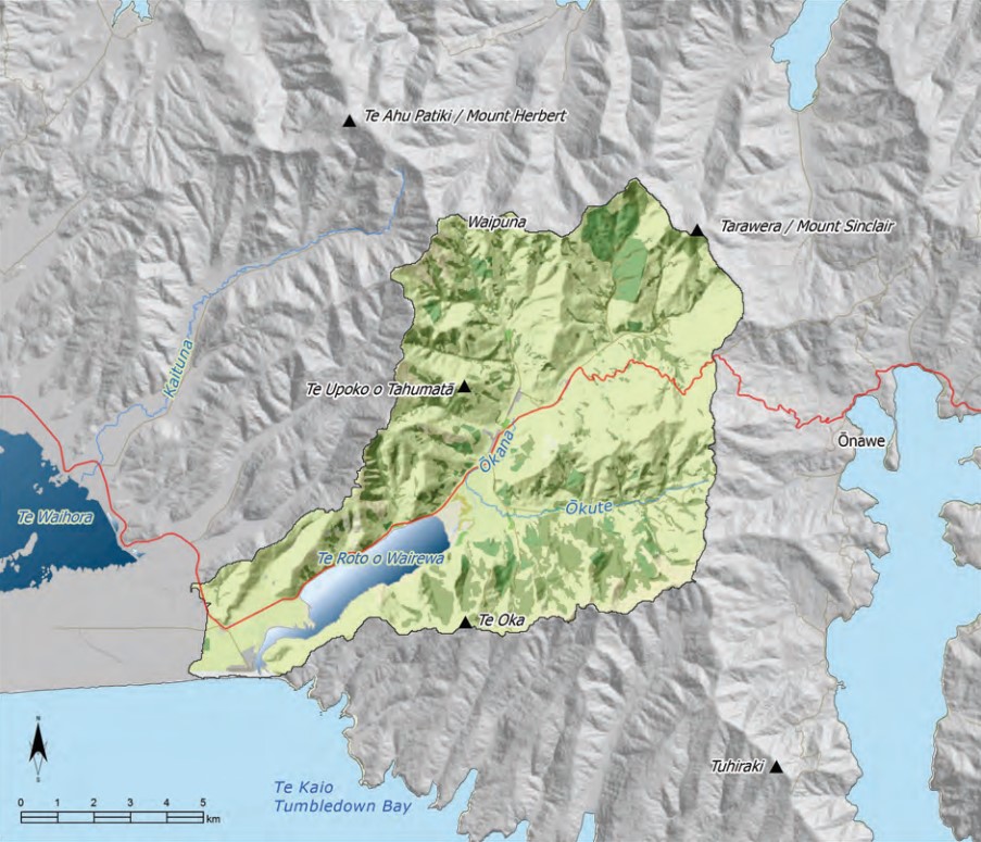
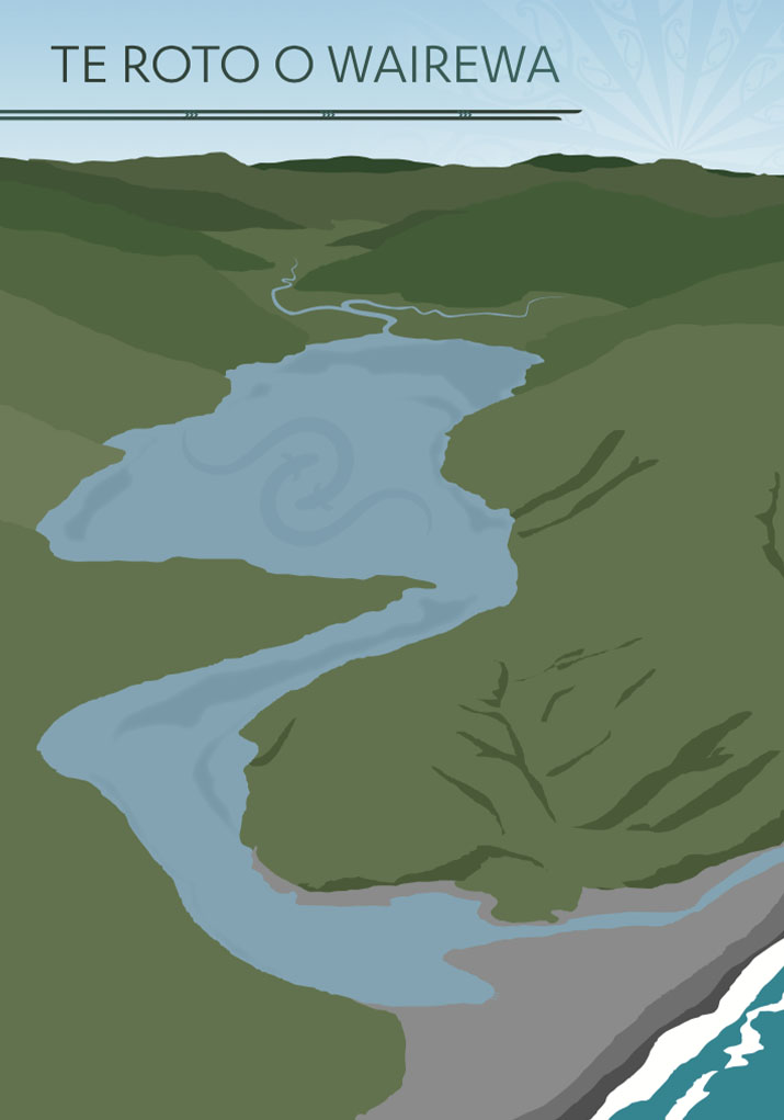
This section addresses issues of particular significance in the catchment of Te Roto o Wairewa. The catchment is centered on the lake, and includes Western and Ōkuti Valleys and the eastern end of Kaitōrete Spit (Map 22).

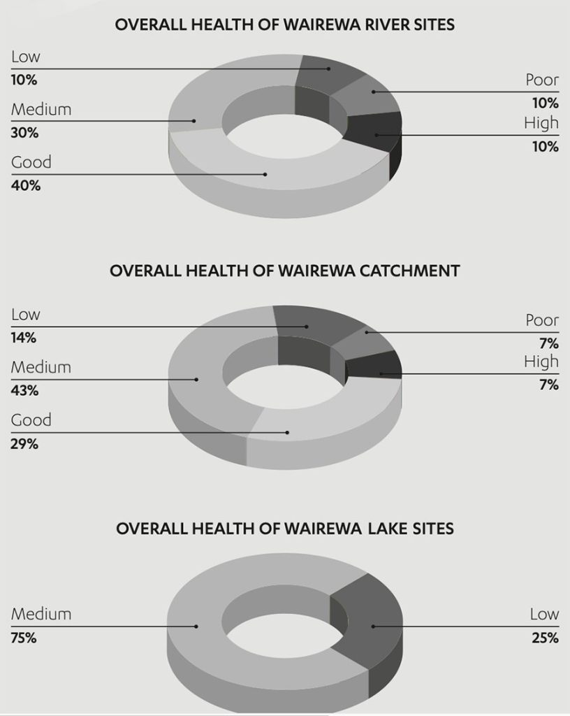
Over the last 160 years, the catchment has been dramatically modified and mahinga kai values severely degraded. The majority of native forest cover was removed between 1860 and 1890 to open up the land for agricultural and pastoralland use, resulting in massive reductions in native bird and plant species. The level of Te Roto o Wairewa has been controlled for flood protection since the 19th century.

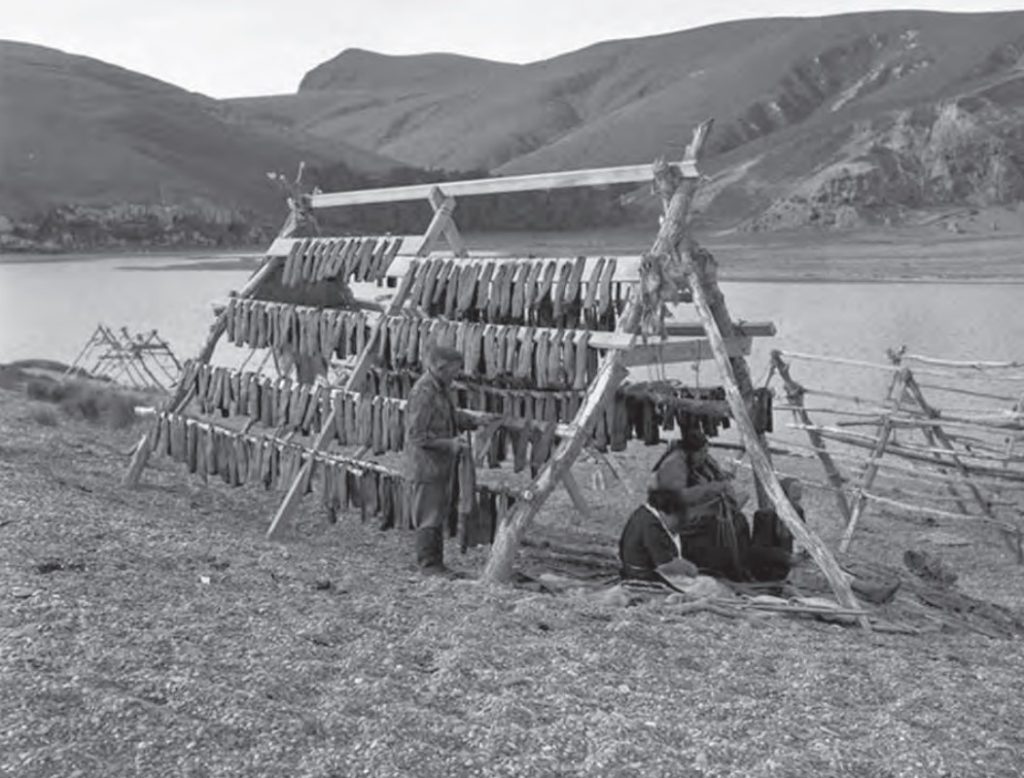
Te Roto o Wairewa is a Statutory Acknowledgement site, recognising the mana of Ngāi Tahu with regard to the lake and guaranteeing tribal involvement in management. Schedule 71 of the NTCSA 1998 is a statement of Ngāi Tahu’s cultural, spiritual, historic, and traditional association to the lake (see Appendix 7). The lake is also one of only two customary lakes in Aotearoa, the other being Horowhenua. This means that only persons belonging to the Ngāi Tahu iwi can take tuna from the lake.

Map 22: Te Roto o Wairewa

Te roto o Waiwera catchment

NOTE: See Section 5.1 (Issue K1 - Recognising Manawhenua) for guidance on identifying the Papatipu Rūnanga with manawhenua and kaitiaki interests in this area.

Ngā Paetae | Objectives

(1) The revitalisation of mahinga kai of Te Roto o Wairewa and its catchment: the tuna fishery and the places and the practices that have been with us for hundreds of years.
(2) The establishment of the Wairewa Mahinga Kai Cultural Park, based on integrated management of the Te Roto o Wairewa catchment and surrounding landscape, Ki Uta Ki Tai.
(3) Ngāi Tahu is instrumental and influential in natural resource management in the catchment, and is setting the standard for best practice.
(4) Strong community and stakeholder relationships are developed and maintained to facilitate the rehabilitation Te Roto o Wairewa.
(5) Improved lake level management that allows the lake to breathe again, and provides improved cultural, environmental, social and economic outcomes.

Ngā Take | Issues of Significance

W1: Cultural Health of the Lake

Issue W1: The cultural health of Te Roto o Wairewa is degraded as a result of:
(a) Lake level management based on arbitrary trigger levels;
(b) Decline of the tuna population;
(c) Contaminants entering the lake as a result of inappropriate land use on lake edge margins;
(d) Nutrient rich sediment entering the lake as a result of poor land cover and inappropriate land use in the catchment; 
(e) Poor water quality in lake tributaries.

Ngā Kaupapa / Policy

Rehabilitating the lake

W1.1 To continue to work towards the rehabilitation of the cultural health of Te Roto o Wairewa as a matter of priority.

W1.2 To continue to progress lake and mahinga kai rehabilitation work under the korowai of the Wairewa Mahinga Kai Cultural Park, including:
(a) Progressing and implementing joint resource consents with CCC to manage lake levels in partnership;
(b) Managing the Te Roto o Wairewa Mātaitai Reserve to improve customary fisheries;
(c) Supporting our freshwater tāngata tiaki;
(d) Managing waterways as the kōhanga of the lake;
(e) Progressing the construction of a permanent opening for the lake;
(f) Addressing the effects of land use on the lake (see Policy W1.4);
(g) Continuing to undertake State of the Takiwā assessments in the catchment to monitor our progress;
(h) Consolidating land gains in the catchment;
(i) Working to have ownership of the lakebed vested to Ngāi Tahu; and
(j) Engaging our people in contemporary and traditional mahinga kai management, gathering and sustainability.

W1.3 To require that local authorities and other agencies with lake management responsibilities recognise the value of Matāuranga Ngāi Tahu as a complement to western science to improve understandings of the lake.

Effects of catchment and lake margin land use

W1.4 To address the effects of catchment and lake margin land use on the cultural health of Te Roto o Wairewa by:
(a) Securing a protected margin around the lake to provide a buffer from land use, with:
(i) Revegetation/restoration of lake margin indigenous vegetation;
(ii) Implementation of a sheep only grazing policy, with some areas removed from grazing completely; and
(iii) Establishment of defined access tracks in sensitive areas, to minimise damage to environment and cultural values from recreational access.

(b) Riparian enhancement, bank stabilisation and fencing for lake tributaries;
(c) Improved and monitored septic tank management and a clear and structured approach to wastewater issues associated with subdivision and development (see Policy W6.5 for an explanation of what this means), including the potential to establish a reticulated sewage system at Te Mata Hāpuku;
(d) Prohibiting aerial top dressing in the catchment;
(e) Investigating the different methods that may be available to remove sediment from the lakebed; and
(f) Monitoring the old rubbish site to ensure no adverse effects on groundwater from leaching of contaminants into soil and then the lake.

W1.5 To require that local authorities include measures in district and regional plans and operations to implement the measures set out in W1.4.

He Kupu Whakamāhukihuki / Explanation

The degraded cultural health of Te Roto o Wairewa and its fisheries is the most significant issue in this catchment. Although the lake continues to be a productive environment, its mauri has been severely degraded.

A State of the Takiwā assessment in 2005 and 2006 showed that catchment land use is having a marked effect on the cultural health of the lake. The assessment highlighted the dramatic loss of cultural health as you move from upper to lower catchment: source to sink (see Box - State of the Takiwā assessment results). Sedimentation and the concentration of nutrients in the sediment of the lakebed are key issues. There is over 1 metre of sedimentation in the lake, equating to approximately 5,000,000 m3 of topsoil which has eroded from the catchment. (1)

“Everything that happens in the catchment affects the lake. The lake becomes a big sink, with no plughole. There is nowhere for the excess nutrients to go.”

Phosphorus is a critical nutrient input into the lake. As the soils of catchment are naturally high in phosphorus, bank erosion on degraded waterways and lack of vegetation cover on land results in high inputs of sediment into the lake during storm events. Compounding this is the increased nitrogen inputs into the lake from lake edge land use and settlement. Nitrogen enters the lake via direct run-off from the land, septic tank leaching, or when the lake levels are high enough to inundate land that has been grazed by stock. High levels of nutrients and low summer lake levels create an ideal environment for Nodularia spumigena (blue-green algae).

Te Roto of Wairewa has little protection from the effects of land use on its margins. Historically, lake margin wetlands acted as a nutrient and sediment filter and played an important role in maintaining water quality. However, very few wetlands remain on the landscape today.

Tāngata whenua have a long-term vision and strategy to rehabilitate the cultural health of Te Roto o Wairewa. The lake was gazetted as a Matāitai Reserve in 2010 to protect customary fisheries interests once the fishery returns. Investigations for a permanent opening for the lake are well underway (Issue W2), and tāngata whenua are working to increase ownership and management of key lands in the catchment, as a means to have greater influence on management issues in the catchment, and to further progress lake rehabilitation activities. Central to this vision and strategy is the bringing together of an extensive network of people willing to work on behalf of the lake.

State of the takiwā assessment results

A State of the Takiwā assessment undertaken in 2005 and 2006 assessed the catchment as in a state of moderate or medium cultural health. The results showed that:

  • The catchment is degraded, particular in the mid-lower catchment where land use is having a marked effect on water quality and biodiversity;
  • There are promising signs for regeneration and restoration, providing the adverse effects of land use are better managed; and
  • There is a dramatic loss of cultural health as you travel down the catchment – source to sink.

An important result of the Assessment was the difference noted between overall catchment health, the health of the rivers and those of the lake itself. Of all sites assessed, 36% ranked as ‘good to high’ compared to 50% of river and 0% of lake sites. This highlights the dramatic loss of health noticed as you travel down the catchment –‘source to sink’.

Health of Waiwera River

Cross reference:

» Issue W2: Lake level management
» Issue W3: Cultural health of waterways in the catchment
» Issue W5: Subdivision and development in the catchment

W2: Lake Level Management

Issue W2: Lake level management should achieve outcomes consistent with the protection and restoration of mahinga kai and other cultural values associated with Te Roto o Wairewa.

Ngā Kaupapa / Policy

W2.1 Te Roto o Wairewa lake level management to be managed jointly by Ngāi Tahu and Christchurch City Council recognising:
(a) Ngāi Tahu as tāngata whenua; and
(b) Christchurch City Council as the agency with statutory responsibility for managing lake levels.

W2.2 To require that local authorities with statutory responsibilities recognise that lake level management and lake openings must reflect mahinga kai values first and foremost. This means:
(a) Continue to progress work on infrastructure for a permanent opening for the lake with the goal of:
(i) “Allowing the lake to breathe”;
(ii) Providing permanent passage into the lake for fish (recruitment);
(iii) Achieving water quality suitable for contact recreation and mahinga kai; and
(iv) Re-creating an estuary environment.

(b) Until a permanent opening is achieved, the existing mechanical opening regime must:
(i) Reflect the protection and enhancement of fisheries values (i.e. openings are triggered by fish recruitment rather than inundation risk); and
(ii) Take into account weather patterns, waves, and predictive flood control.

He Kupu Whakamāhukihuki / Explanation

Te Roto o Wairewa was historically a tidal hāpua. Until whaling times, the lake had a permanent outlet to the sea and waka could travel right into the forested inlet, which was then known as Mowry (Māori) Harbour. In those days, the flush of nutrients and fresh water flowing into the sea acted as a beacon; attracting the young tuna into the waterways of the catchment. The ebb and flow of these tides is how Wairewa got its name.

The lake eventually closed due to a build up of gravel pushed north from the Waitaki, Rangitata and Rakaia rivers. The gravels were deposited at Te Mata Hāpuku end of Kaitōrete, and over many years gradually closed the mouth to the estuary. The closing had significant impacts on the fishery:

The moment the estuary closed the eel fishery was under threat. Unable to scent a strong beacon and having to climb over an ever increasing gravel barrier, fewer and fewer elver found their way back into the lake.” (2)

Since 1946, the lake has been mechanically opened at arbitrary times and at various levels to reduce the threat of flooding. The regime was initiated after the costs for the preferred option of creating some form of permanent opening were deemed too high, and continued without recourse to cultural, social or environmental considerations. The regime has always been unacceptable to tāngata whenua, and has had a profound effect on the cultural health of the lake and its fisheries (see Box - Recruitment of tuna into Te Roto o Wairewa).

The focus of Policies W2.1 and W2.2 is to establish a lake level management regime that protects and enhances mahinga kai values and the customary relationship of tāngata whenua with Te Roto o Wairewa. This means that water quality and fish recruitment and escapement will replace flood management and drainage as the drivers behind the timing and duration of lake openings. In 2008, Wairewa Rūnanga was granted resource consent to build an experimental rock groyne to test the feasibility of creating a permanent mouth opening. The approach is based in bio-engineering: testing the feasibility of reinstating a permanent opening to the lake as a means to harness the available natural energy and allowing the lake to breathe again.

Recruitment of tuna into Te Roto o Wairewa

The lake opening regime restricts the recruitment of tuna. It takes approximately 35 years for tuna in the lake to grow to heke size and run the gauntlet of the drains out to the ocean. Research commissioned by tāngata whenua showed that there are no longer the stocks available in the lake to keep the fishery alive, and that without immediate and effective action, the last heke tuna will be hooked from the drains and our most valuable mahinga kai could be lost in less than 10 years.


It would be interesting to determine how many stock units are protected by maintaining a low lake level and enabling lake margin grazing, vs. how many of our fish are affected by poor water quality and low lake levels.”

Every season Ngāi Tahu individuals and whānau groups gather at the tuna drains, reconnecting ties and friendships, sharing knowledge, passing on skills and expertise while fishing tuna. Often they are returning after a long absence to a place they frequented as children following in fathers or grandfather’s footsteps.

When the sun comes up they are together again busy cleaning and preparing their eels. The whata are filled and the tuna hung drying in the ever present wind. The smoke houses are fired up and for a few short months Te Mata Hāpuku (Birdlings Flat) resonates with the sounds, scents and sights of our ancestors.”
(3)

Photo: Wairewa Whānau drying tuna on a whata at Te Roto o Wairewa. | Source: Alexander Turnbull Library, Tourist and Publicity Department Collection Reference: 1/2-040042.|

Wairewa Whānau drying tuna on a whata at Te Roto o Wairewa. Source: Alexander Turnbull Library, Tourist and Publicity Department Collection Reference: 1/2-040042

Cross reference:

» Issue WM1: Cultural health of the lake

W3: Cultural Health of Waterways

Issue W3: The cultural health of waterways in the catchment has declined as a result of:
(a) Stock access and run-off;
(b) Degradation of riparian areas;
(c) Sewage and stormwater disposal; and
(d) Soil erosion and sedimentation.

Ngā Kaupapa / Policy

W3.1 To require that waterways in the Te Roto o Wairewa catchment are managed as kōhanga, consistent with managing the catchment as mahinga kai. This means:
(a) Protection of mauri as a first order principle;
(b) Discourage takes of fish until waterway health is improved and lake fishery rehabilitated;
(c) Encourage landowners to take responsibility for riparian margin planting and management;
(d) Prohibit the discharge of contaminants to waterways; and
(e) Prohibit stock access to waterways.

W3.2 To address water quality issues in the rivers and streams of the catchment with reference to general policies on Water quality (Section 5.3 Issue WM6).

Effects of forestry on Poronui


W3.3
To identify Poronui / Reynolds Stream as a waterway in good cultural health that is at risk from forestry activities in the Ōkuti valley.

W3.4 To continue to undertake State of the Takiwā assessments to monitor the cultural health of Poronui.

He Kupu Whakamāhukihuki / Explanation

The waterways in the Te Roto o Wairewa catchment flow from maunga to lake, Ki Uta Ki Tai. This means that the cultural health of the lake is directly related to the cultural health of waterways. For this reason, tāngata whenua sought to include the catchment’s waterways in the Wairewa Matāitai Reserve. The matāitai would protect the waterways as kōhanga, or nurseries for customary fish species, consistent with managing the catchment for mahinga kai. While the matāitai was ultimately limited to the lake, tāngata whenua maintain that the waterways should still be managed as kōhanga.

Beginning as springs in the Mountains that surround our marae, the streams of Waipuna, Ōpouwaho (also known as Ōpuahou), Hikuika and Puaha flow down the hills and join Hukahukaturoa before going on to meet and form the Ōkana that flows behind our marae. Travelling on to the Ōkuti the waters reach Takiritawai (also known as Kakerikawai) at the headwater of our lake." (4)

Water quality and quantity in the catchment’s waterways has decreased significantly in the memory of the people of Wairewa. Land use change has reduced the catchment’s water yield and increased the presence of contaminants in water. Tāngata whenua also question whether intensive land and water use across Ngā Pākihi Whakatekateka o Waitaha is affect - ing freshwater resources of the Te Roto o Wairewa catchment.

Tāngata whenua are also concerned with the effects of commercial forest plantations on waterways, particularly in Ōkuti Valley. Land clearance, planting and harvesting of plantations can result in sedimentation and contamination of waterways. Plantations can also negatively affect catchment water yield, as pine trees absorb a significant quantity of water, including stormwater, that would otherwise contribute to the catchment’s water yield.

Cultural health assessments in the catchment ranked Poronui/Reynolds Stream in the upper Ōkuti valley as the best site in the catchment for cultural health. Monitoring the potential effects of forestry in the valley on this waterway is an important kaupapa for tāngata whenua.

Our old water quality policy, when we were young, was to look upstream before you drink!”

Cross reference:

» Issue W1: Cultural health of the lake
» Issue W6: Restoring important places
» General policies in Section 5.3 – Issue WM3: Priorities for freshwater use; and Issue WM8: Water quality

W4: Māori Reserve Land

Issue W4: Recognition of owners of Māori Reserve land.

Ngā Kaupapa / Policy

W4.1 When a proposed activity is adjacent to or may impact on Māori Reserve land, consultation must occur with owners or trustees of that reserve land.

W4.2 To require that district and regional plans contain provisions to address the issues and barriers associated with the use and development of ancestral and Māori reserve land for the purposes for which it was set aside, as per general policy on Papakāinga (Section 5.4 Issue P5).

He Kupu Whakamāhukihuki / Explanation

There are a number of Māori Reserves located in the catchment of Te Roto o Wairewa: Wairewa, Otawira, Takiritawai, and Te Pourua. When a proposed activity is adjacent to or may impact on Māori Reserve land, the applicant must consult with the owners or trustees of that land as individuals, in addition to the Papatipu Rūnanga.

Cross reference:

» General policy on papakāinga (Section 5.4 Issue P5)

W5: Subdivision and Residential Development

Issue W5: Lifestyle block and residential intensification has the potential to affect:
(a) The mauri of freshwater resources;
(b) The cultural health of Te Roto o Wairewa; 
(c) Wāhi tapu, wāhi taonga and archaeological values.

Ngā Kaupapa / Policy

W5.1 To use the following principles as a guide for assessing subdivision and residential land development in the catchment of Te Roto o Wairewa:
(a) Activities should be consistent with managing the catchment as mahinga kai;
(b) Settlements should be concentrated in areas sustainably able to absorb change (i.e. with regards to energy, water, waste and the protection of significant sites); and
(c) Natural and cultural landscapes that are largely unmodified should be protected from subdivision and residential development.

W5.2 To require a clear and structured approach to managing sewage and water infrastructure in the catchment of Te Roto o Wairewa, including:
(a) Subdivision consents must be applied for and considered alongside discharge consents;
(b) Careful consideration of reticulated vs. individual systems for sewage disposal, including consideration of the nature of land, the economic and cultural cost of reticulation and the economic and cultural cost of not reticulating;
(c) Detailed information on water supply, wastewater and stormwater as prerequisite for resource consent applications; and
(d) A requirement that all new residential developments install roof collection systems for rainwater. Streams and springs should not be relied on.


Protection of wāhi tapu and wāhi taonga


W5.3
To utilise the methods set out in general policy on Wāhi tapu me wāhi taonga and Silent files (Section 5.8, Issues CL3 and CL4) to protect wāhi tapu and wāhi taonga from potential effects associated with subdivision and residential land development activity in the catchment.


Te Mata Hāpuku


W5.4
To continue to work with Christchurch City Council to develop a long term solution for effluent disposal for at Te Mata Hāpuku (i.e. reticulated system) to:
(a) Protect water quality and the cultural health of the lake; and
(b) Protect wāhi tapu and wāhi taonga.

He Kupu Whakamāhukihuki / Explanation

The last decade has seen a marked land use change from relatively low impact pastoral farming to intensified lifestyle communities in the Te Roto o Wairewa catchment. This is particularly evident in areas such as Te Mata Hāpuku, Western Valley and the outskirts of Little River.

Given the potential for effects on cultural values, tāngata whenua must participate in decision making on how development occurs in the catchment. It is imperative that subdivision and residential land development, including lifestyle blocks, are considered for consistency with the vision and objective for the wider catchment (i.e. lake as mahinga kai), and the cumulative effects on cultural and environmental values.

Tāngata whenua seek to enable development in areas that can absorb growth and change, like the community of Little River, while recognising the limitations of existing community infrastructure such as water supply. As with other areas of Te Pātaka o Rākaihautū, community water supply infrastructure needs to reflect the limits of water availability, by adopting methods such as rainwater collection. Careful consideration is required to identify areas that are able to absorb land use intensification and change, without compromising existing landscape values or future aspirations that rely on maintaining open space (e.g. restoration of areas of significant native vegetation).

Even with good septic systems like Oasis Clearwater, there is still the issue of density and cumulative effects.”

Cross reference:

» Issue W6: Restoring important places (with case study on Te Mata Hāpuku)
» General policy on subdivision and development (Section 5.4, Issue P4)
» General policy on coastal land use and development (Section 5.6, Issue TAN7)

W6: Restoring Important Places

Issue W6: To enhance and restore cultural important sites and places in the catchment.

Ngā Kaupapa / Policy

W6.1 To enhance and restore culturally important sites in the catchment, including but not limited to:
(a) Continuation of the existing program of fencing and riparian planting at Ōkana Stream at Pā Road;
(b) Riparian planting at Takiritawai stream at the headwaters of Te Roto of Wairewa; and
(c) Fencing, landscaping, erection of pou, and naming of the site at Browns Pit, where Te Whare Tūpuna Makō is buried.

He Kupu Whakamāhukihuki / Explanation

In addition to a general objective to restore the cultural health in the catchment through rehabilitating the lake, there are number of specific projects that are identified as matters of priority. One of these is the restoration and landscaping of Browns Pit at Birdlings Flat, where Te Whare Tūpuna Makō is buried. The old marae hall was demolished in January 2008 to make way for a new whare. Browns Pit was chosen given the proximity to Marokura nui, Marokura iti, Waikākahi, Te Mata Hāpuku and Ōruaka, and the suitability of the site for fencing, landscaping and the erection of pou to mark the site.

CASE STUDY: Te Mata Hāpuku (Birdlings Flat)

Te Mata Hāpuku (a reference to the groper fisheries that were once plentiful in the area) was an extensive Pā site that our people occupied in the 1800’s. Our people fought to have this area recognised and it was finally recognised as a Māori Reserve in 1876. Despite this, the reserve land and the area around it was sold by the provincial survey department’s Wastelands Board in 1877. Our people at the time complained bitterly at this miscarriage of justice. Eventually the provincial government tried to repurchase the area but ultimately decided not to proceed due to the exorbitant price the landowner placed on the land. To add insult to injury, the landowner obtained 10 pounds from the government when two of our people were charged with trespassing on what had effectively been their own land.

The sad saga of Te Mata Hapuku still haunts us to this day. In 1999 local authorities re-zoned the land as residential and in 2004 a subdivision was granted via non-notified consent. This meant that we were unable to put in place appropriate processes to protect cultural sites, or to address issues such as a water supply, wastewater disposal or stormwater management.

Today the tāngata whenua continue to work with residents, local authorities and the Historic Places Trust to facilitate robust cultural, community and environmental outcomes with respect to effluent disposal and the protection of sites of significance. One method used to achieve these outcomes is the use of ‘hot zones’ to protect sites of significance. Each zone (see map below) has specific requirements, reflecting the level of risk to wāhi tapu and wāhi taonga values.

Image source: Wairewa Rūnanga.

archeological sites kairoete spit

W7: Wāhi Tapu me Wāhi Taonga

Issue W7: Protection, management and access to wāhi tapu and wāhi taonga.

Ngā Kaupapa / Policy

W7.1 To recognise and provide for the Te Roto o Wairewa as a Ngāi Tahu cultural landscape with significant historical, traditional, cultural and contemporary associations.

W7.2 To increase the ability of Ngāi Tahu whānui to access wāhi tapu and wāhi taonga on private land using the methods set out in general policy on Access to wāhi tapu and wāhi taonga (Section 5.8 Issue CL5).

W7.3 To utilise the methods set out in general policy on Wāhi tapu me wāhi taonga and Silent files (Section 5.8, Issues CL3 and CL4) to protect wāhi tapu and wāhi taonga from potential effects associated with subdivision and residential land development activity in the catchment.


Kaitōrete Spit

W7.4 To identify Kaitōrete Spit as a high risk area for the potential for land use to modify, destroy or damage archaeological sites.

He Kupu Whakamāhukihuki / Explanation


The catchment of Te Roto o Wairewa is a rich cultural landscape. Key features of this cultural landscape include:

  • Waikākahi – Tutekawa’s fishing settlement and pā;
  • Te Ana o Koko – cave near the outlet of the lake;
  • Wairewa pā (east bank of the Ōruāka stream);
  • Marokuraniu and Marokuraiti – Devils Knob;
  • Te Puia – pa at the tip of spur at the foot of Prices Valley;
  • Ōruāka Pā; and
  • Te Mata Hāpuku.

Archaeological sites continue to be at risk from both natural erosion and human activity, particularly along the eastern end of Kaitōrete Spit. For example, ancient middens located along Baileys Road continue to be exposed as a result of grading.

Many sites of significance, locally and tribally, are on private land. For example, Waikakāhi is one of the most significant pā sites in the Ngāi Tahu rohe, but when Ngāi Tahu whānui want to access the site they have to seek permission from the landowner. Access to sites such as Waikākahi is dependent on the goodwill of private landowners. Another example is Te Upoko o Tahumatā, the ancestral maunga standing behind Wairewa marae, also on private land.

“There are areas within our takiwā that we are shut out of as a result of little understanding of the significance of the areas.”

“Every time we want to visit our maunga we have to ring the farmer before we can sit up there.”

Cross reference:

» General policies in Section 5.8 – Issue CL1: Cultural landscapes; Issue CL2: Ngāi Tahu Cultural Mapping Project; Issue CL3: Wāhi tapu me wāhi taonga; and Issue CL5: Access to wāhi tapu and wāhi taonga
» Section 6.11, – Issue TW11 (Kaitōrete Spit)

W8: Climate Change

Issue W8: Climate change is an important consideration for the management of Te Roto o Wairewa.

Ngā Kaupapa / Policy

W8.1 To require that potential changes to Te Roto o Wairewa and adjacent lands as a result of climate change induced sea level rise are recognised and provided for in all planning and consenting activities in the catchment.

He Kupu Whakamāhukihuki / Explanation

Climate change is an important consideration with regard to achieving Ngāi Tahu objectives and aspirations for the Te Roto o Wairewa catchment. Specific issues include:
(a) Potential changes to the depth and flow of waterways in the catchment, as a result of less rainfall. This will affect the cultural health of the waterways and therefore Te Roto o Wairewa;
(b) Sea level rise would pose a threat to Mata Hāpuku/ the community of Birdlings Flat;
(c) Sea level rise could result in increased erosion and exposure of significant sites on Kaitōrete Spit and the lake edge; and
(d) Climate change induced changes to waterways and coastal areas could result in a loss of mahinga kai resources, sites and opportunities.

Cross reference:

» General policy on climate change (Section 5.2, Issue R2)

END NOTES / REFERENCES

  1. Wairewa Group Annual Report 2005-2006.
  2. Ibid.
  3. Wairewa Ngāi Tahu Fund Application, n.d.
  4. Cranwell, I. and M. Wakefield. 2008. Hikoi Whakawhānaukataka. Wāhaka Tuatahi. Te Rohe o Wairewa. Wairewa Rūnanga.
  5. Tau, TM., Goodall, A., Palmer, D. and Tau, R. 1990. Te Whakatau Kaupapa: Ngāi Tahu Resource Management Strategy for the Canterbury Region. Aoraki Press: Wellington.