IMP: Ngā Take ā-hikawai Me Ngā Kaupapa | Catchments

6.9 Poranui ki Timutimu

Wāhi Tuaono | Part 6

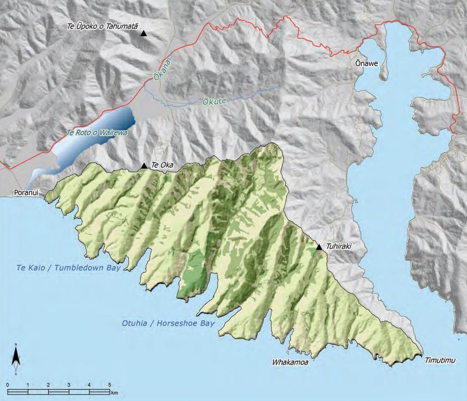
6.9 Poranui ki Timutimu [PT]

Poranui ki Timutimu

This section addresses issues of particular significance from Poranui to Timutimu, encompassing the whole of the southern bays between Akaroa Harbour and Kaitōrete Spit (Map 19). It is characterised by numerous small narrow catchments extending Ki Uta Ki Tai, from hill to sea.

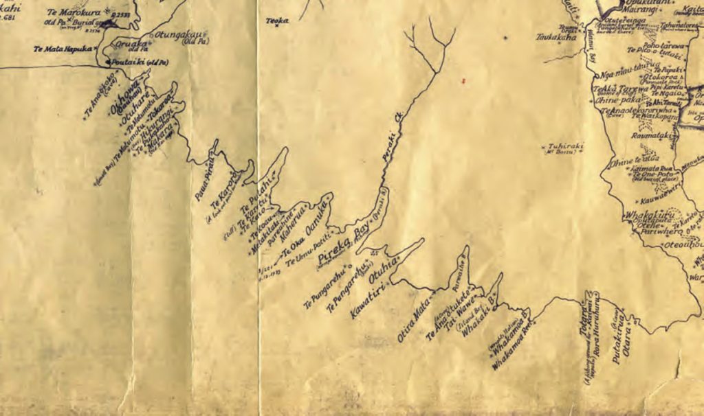
As with other coastal areas of Te Pātaka o Rākaihautū, the southern bays are a rich cultural landscape with a long history of Ngāi Tahu land use and occupancy. Some of the earliest Māori occupation on Te Pātaka o Rākaihautū was in the southern bays. Evidence of ancient settlements, fishing grounds, birding sites and urupā remain on the physical landscape and in oral traditions today.

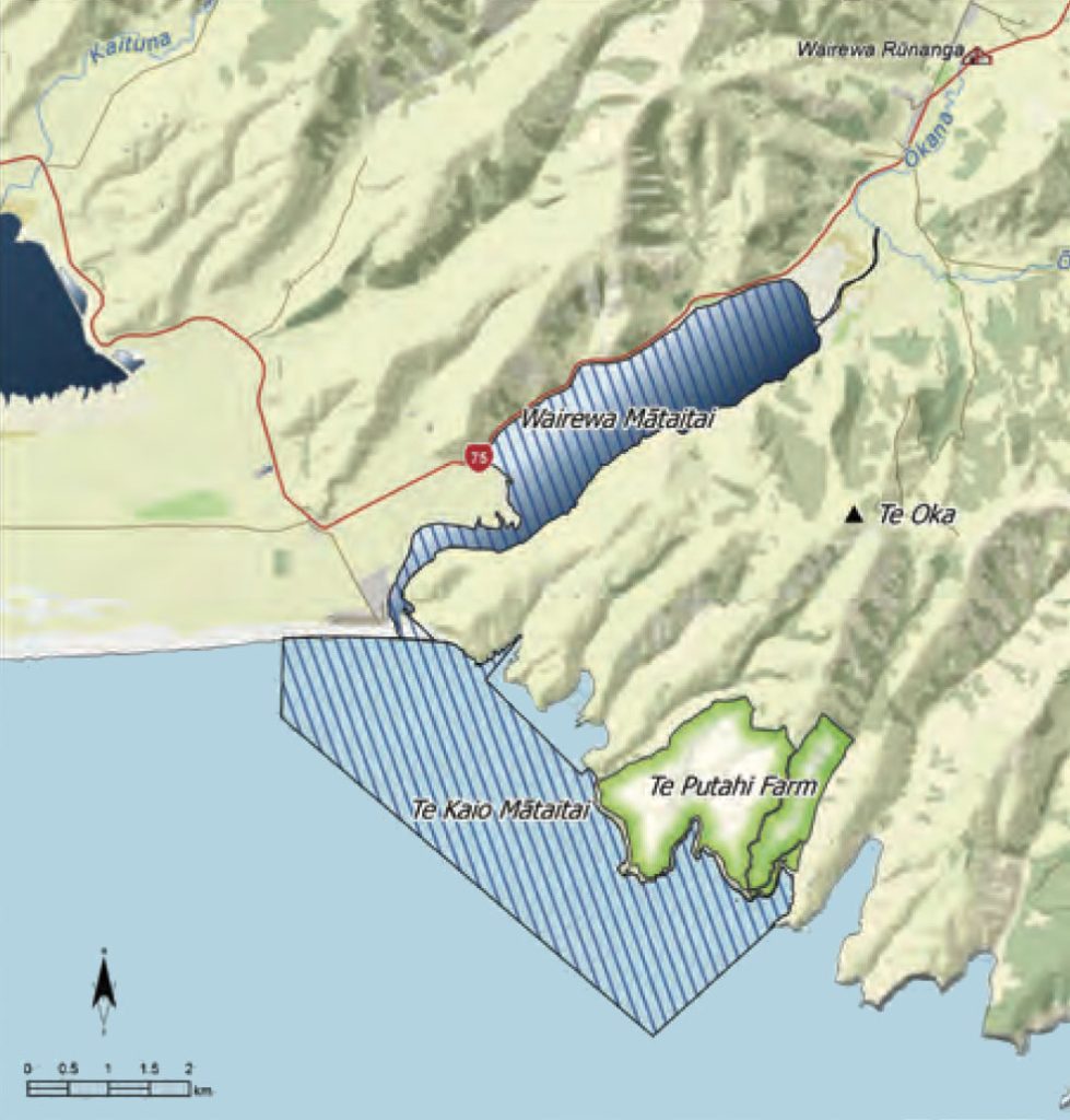
Two significant features on the contemporary cultural landscape are Te Putahi Farm and the Te Kaio Mātaitai reserve. These places are part of the long term vision of the tāngata whenua to establish a Mahinga kai Cultural Park in the takiwā, restoring the traditional fisheries that the area was once famous for, and creating contemporary mahinga kai opportunities including the production of organic beef, lamb and vegetables.

Map 19: Poranui ki Timutimu

Map19 Poranui ki Timutimu

NOTE: See Section 5.1 (Issue K1 - Recognising Manawhenua) for guidance on identifying the Papatipu Rūnanga with manawhenua and kaitiaki interests in this area.

Ngā Paetae | Objectives

(1) Protection and enhancement of the waterways that flow through the southern bays catchments, Ki Uta Ki Tai, and the waipuna that are their source.
(2) Papatipu Rūnanga management of Te Putahi farm and the Te Kaio Mātaitai as part of a larger Wairewa Mahinga Kai Cultural Park.
(3) Protection of wāhi tapu and wāhi taonga, and other cultural landscape values, from inappropriate land use and development, including coastal development.
(4) The continued expression of customary rights and interests in coastal space in the southern bays catchments.
(5) Protection and enhancement of indigenous biodiversity in the southern bays catchments, including restoration of degraded areas, the protection of remnants and the enhancement of mahinga kai resources and opportunities.

Ngā Take | Issues of Significance

PT1: Cultural Landscapes

Issue PT1: The protection of cultural landscape values associated with the southern bays, including wāhi tapu, wāhi taonga, ingoa wāhi and mahinga kai.

Ngā Kaupapa / Policy

PT1.1 To recognise and provide for the southern bays as a Ngāi Tahu cultural landscape with significant historical, traditional, cultural and contemporary associations.

PT1.2 To require that effects on cultural heritage values are fully and effectively assessed as part of all resource consent applications for activities in the southern bays' catchments.

PT1.3 To maintain and enhance the ability of Ngāi Tahu whānui to access particular coastal areas that are on private land, by:
(a) Engaging landowners to develop management plans to protect sites and enable access; and
(b) Using mechanisms such as LIMs and consent notices to inform new landowners of culturally significant sites.

He Kupu Whakamāhukihuki / Explanation

As with other coastal areas of Te Pātaka o Rākaihautū, the southern bays have a long history of Ngāi Tahu (and earlier) land use and occupancy. The bays are an important cultural landscape for Ngāi Tahu, with archaeological evidence and oral tradition maintaining the connection between people and place.

The southern bays show evidence of some of the earliest Maori occupation on Te Pātaka o Rākaihautū, including pā sites, fishing settlements, birding sites, and urupā (see Map 20 - Ingoa wāhi associated with the southern bays). Some sites are registered archaeological sites (NZAA) and 298 silent files, while others are recorded in oral traditions and historical sources.

There are two silent files located in the region Poranui to Timutimu. Silent file 029 includes the land and coastal waters of Oashore, Hikuraki and Tokoroa bays. Silent file 022 includes the land and coastal waters from Timutimu Head to Whakamoa Bay.

Map 20:  Ingoa wāhi associated with the southern bays. | Source: Māori Place Names of Banks Peninsula 1894. Christchurch City Library digital map collection

Ingoa wahi associated with the southern bays of Banks Peninsular

Cross reference:

» General policies in Section 5.8 – Issue CL1: Cultural landscapes; Issue CL2: Ngāi Tahu cultural mapping project; Issue CL3: Wāhi tapu me wāhi taonga; and Issue CL5: Silent files
» General policy on coastal land use and development (Section 5.6, Issue TAN7)
» General policy on access to coastal areas (Section 5.6, Issue TAN8)

PT2: Protection of Customary Fisheries

Issue PT2: Protection of customary fisheries in the southern bays.

Ngā Kaupapa / Policy

PT2.1 To continue to implement the Te Kaio Mātaitai Reserve, including:
(a) Development of bylaws to control the species and amounts taken;
(b) Development of bylaws that promote sustainability as opposed to focusing on legal takes of particular species; and
(c) Consultation with the wider community as an integral part of managing the mātaitai reserve.

PT2.2 To require that coastal water quality in the southern bays catchments is such that customary fisheries are protected, and tāngata whenua can engage in mahinga kai activities.

He Kupu Whakamāhukihuki / Explanation

Te Kaio is an ancient site of significance that is now part of the contemporary vision of the Papatipu Rūnanga to restore mahinga kai traditions to the landscape and people. As with the mātaitai reserve located on Te Roto o Wairewa (Section 6.10), the Te Kaio Mātaitai is intended to protect customary interests in fisheries in anticipation of an improvement in fisheries stocks (see Map 21 for the location of the Mātaitai). The impact of commercial fishing in this area is evidenced by depleted fish stocks and the damage to valuable kaimoana beds as a result of bottom trawling. The intention of the mātaitai is that, without commercial fishing, stocks in both the lake and the ocean will recover. Mātaitai are about kaitiakitanga. They give Ngāi Tahu the ability to form bylaws that control what is taken from the sea. For the Papatipu Rūnanga that established the Te Kaio Mātaitai, it is important that the mātaitai is managed through bylaws that focus on sustainability as opposed to legal takes of particular species, and that management and the development of bylaws occur in consultation with the community. The Te Kaio Mātaitai ties the concept of Ki Uta Ki Tai and mahinga kai directly to Te Putahi farm (Issue PT3), reinforcing the cultural footprint of Ngāi Tahu and signaling the willingness of Papatipu Rūnanga to ‘manage their own patch’.

Map 21: Te Putahi farm location

Map 21 Te Putahu farm location

Cross reference:

» General policy on tools to protect customary fisheries and the marine environment (Section 5.6 Issue TAN4)

PT3: Te Putahi

Issue PT3: The continued development of Te Putahi farm.

Ngā Kaupapa / Policy

PT3.1 To continue to develop Te Putahi farm according to the following vision:
(a) Te Putahi farm as part of the Wairewa Mahinga Kai Cultural Park that protects the whenua, koiora kanorau, wai māori and wai moana of Papatūānuku, Ki Uta Ki Tai; and
(b) Te Putahi farm is developed and managed as a contemporary kaupapa Māori model of kaitiakitanga for all its mahinga kai resources to help inspire members, the Ngāi Tahu Whānui and the wider community as to how a whole ecosystem mahinga kai me te ahuwhenua approach to kaitiakitanga can be culturally, environmentally and economically sustainable and resilient. (2)

PT3.2 To restore the Te Kaio catchment as a matter of priority. This includes:
(a) Replanting pīngao in the dune and beach area;
(b) Riparian planting, and stream fencing to keep stock out; and
(c) Gorse management.

He Kupu Whakamāhukihuki / Explanation

Te Putahi is a farm owned by Wairewa Rūnanga. The farm runs from Te Kaio south to Makara (Magnet Bay), and overlooks Kaitōrete Spit, Mata Hāpuku and the Te Kaio mātaitai reserve (see Map 21).

Te Putahi farm comprises 449 hectares with diverse micro-climates and has not used any synthetic fertilisers or pesticides for over 20 years. It is the first farm to be accredited under the Ngāi Tahu mahinga kai system and it is currently in the process of converting to organic production methods. The farm is part of the contemporary vision of the Papatipu Rūnanga to restore mahinga kai traditions to the landscape and people. Over time Te Putahi will become an integral part of the Wairewa Mahinga Kai Cultural Park, supplying organic beef, lamb and vegetables.

Map 21: Te Putahi farm location

Map 21 Te Putahu farm location

PT4: Waterways and Waipuna

Issue PT4: Protecting the mauri of waterways in the southern bays catchments.

Ngā Kaupapa / Policy

PT4.1 To require that waterways in the southern bays catchments are managed Ki Uta Ki Tai. This means recognising and providing for:
(a) The relationship between land use and water quality and quantity; and
(b) The relationship between land use and coastal water quality, given the nature of the short, steep catchments and a relatively short distance between land use and coastal water quality.

PT4.2 To require that waipuna in the southern bays catchments, as the source of many of the waterways, are recognised and protected as wāhi taonga, as per general policy on Wetlands, waipuna and riparian margins (Section 5.3 WM13).

PT4.3 To encourage landowners to take responsibility for riparian planting and management and to support incentives and funding schemes to assist them to do so.

PT4.4 To construct fencing and undertake riparian planting on Te Kaio stream as a matter of priority.

He Kupu Whakamāhukihuki / Explanation

The protection of waterways is a significant issue in the southern bays catchments. Surface water is the primary source of water for domestic and stock purposes. Land use activities such as pastoral farming and forestry can have effects on riparian areas and water quality if not managed appropriately. Streams flow from hill to sea within a relatively short and steep catchment, and therefore the effects of land use on waterways will also be seen in coastal water quality and mahinga kai.

Cross reference:

» General Policy on Wai Māori (Section 5.3)

PT5: Coastal Land Development

Issue PT5: Coastal land development can have effects on Ngāi Tahu values and the environment.

Ngā Kaupapa / Policy

PT5.1 To require that local government recognise and provide for the interests of tāngata whenua in coastal land use and development in the southern bays, as per general policies on Coastal land use and development (Section 5.6 Issue TAN7), in particular:
(a) Protecting wāhi tapu and wāhi taonga, and Ngāi Tahu access to these;
(b) Recognising the short and steep nature of the southern bays catchments, and therefore the relatively short distance between land use on coastal water quality;
(c) Protecting the natural character and remoteness of these catchments, including headlands, skylines and the foreshore;
(d) Protecting coastal water quality; and
(e) Protecting Ngāi Tahu interests with regard to protecting customary fisheries (see Issue PT2).

He Kupu Whakamāhukihuki / Explanation

The southern bays coastal landscape is of particular significance to Ngāi Tahu given the long and continued association with the coastal environment (see Issue PT1). For this reason, a cultural landscape approach is required to identify and protect Ngāi Tahu values and interests from the adverse effects of coastal land development. A cultural landscape approach shifts the focus from sites of significance to the larger landscapes that they occur in.

Many of the southern bays are remote and have little development intrusion. More accessible bays may have potential for certain coastal land development activities. For Ngāi Tahu, any coastal land development must be sustainable and appropriate; fitting into the landscape rather than working against it, and enhancing existing values rather than degrading them.

Given the high degree of natural character and richness of cultural landscape values in the southern bays, the RMA 1991 clearly provides protection for the coastal environment and the relationship of Ngāi Tahu to it as a matter of national importance.

Cross reference:

» Issue PT1: Cultural landscapes
» Issue PT8: Indigenous biodiversity
» General policies in Section 5.6 – Issue TAN7: Coastal land use and development; and Issue TAN8: Access to coastal areas
» General policy on access to wāhi tapu and wāhi taonga (Section 5.8 Issue CL5)

PT6: Commercial Forestry

Issue PT6: Tāngata whenua have significant concerns with some commercial forestry activities in the southern bays catchments.

Ngā Kaupapa / Policy

PT6.1 To oppose large scale, exotic commercial forestry plantations in the southern bays catchments, due to the significance of effects relating to:
(a) Loss of natural landscape values and indigenous biodiversity;
(b) Establishment and spread of wilding trees;
(c) Reduction in stream flows and catchment water yield; and
(d) Sedimentation of waterways.

PT6.2 To encourage, where forestry is desired for soil stabilisation or commercial purposes, small scale woodlots of specialised native timber.

He Kupu Whakamāhukihuki / Explanation

Tāngata whenua are concerned with the effects of forestry on water resources and the landscape in the southern bays catchments, and see the need to control the establishment of new commercial plantations. One example is the nature and extent of vegetation that is cleared to establish forestry plantations. Large areas of kānuka and mānuka may be cleared to make way for forestry (see Issue PT7), and this is contrary to tāngata whenua efforts to restore these and other native species on the landscape. Forestry is a common land use activity in catchments such as Peraki Bay.

"We’ve planted 1/4 ha of kānuka, mānuka and other species, and will have to wait years for these trees to mature, and yet we see proposals from forestry companies to clear 30 ha of kānuka and mānuka ‘scrub’ in a few days."

Cross reference:

» Issue PT4: Waterways and waipuna
» Issue PT7: Vegetation clearance
» General policies in Section 5.4 – Issue P14: Commercial forestry; and Issue P15: Wilding trees

PT7: Vegetation Clearance

Issue PT7: If not managed appropriately, vegetation clearance and burning can result in:
(a) Continued fragmentation and loss of remnant native bush and habitat, particularly along streams and gullies;
(b) Soil erosion and increased sedimentation into waterways and coastal waters;
(c) Changes to catchment water yields;
(d) Loss of opportunities for regeneration of indigenous biodiversity;
(e) Loss of nutrients and carbon from the soil; and
(f) Loss of cultural and natural landscape values.

Ngā Kaupapa / Policy

PT7.1 To require that local authorities recognise and provide for the effects of vegetation clearance and burning activities on landscape, biodiversity, water yield and soil health in the southern bays catchments.

PT7.2 To assess vegetation clearance activities with reference to general policy on Vegetation clearance and burning.

He Kupu Whakamāhukihuki / Explanation

The hills and valleys of Te Pātaka o Rakaihāutū have a long history of vegetation clearance. The once forested landscape is now dominated by pastoral farming. While there are significant efforts to protect and restore indigenous biodiversity, maintaining the land for pasture means that vegetation clearance still occurs. Vegetation clearance occurs by mechanical clearing, spraying and burning.

One of the most significant concerns for tāngata whenua is that the clearing of ‘scrub’ for pasture often includes indigenous species such as kānuka, mānuka and pātōtara (mingimingi). Kānuka (Kunzia ericoides) and mānuka kahikāto (Leptospermum scoparium) and pātōtara (Leucopogon fraseri) are taonga species under the NTCSA 1998 (Schedule 97). It is even more concerning when vegetation is cleared in gullies and along waterway margins. Clearance of vegetation can result in small fragments of native bush; and this can have important implications for the regeneration of podocarps in the takiwā.

The southern bays are steep catchments and therefore vegetation clearance must be managed to avoid loss of slope stability, and the erosion and sedimentation of waterways. Vegetation clearance also needs to be considered alongside the significant restoration efforts occurring on Te Pātaka o Rākaihautū.

Cross reference:

» General policy on vegetation buring and clearance (Section 5.4 Issue P2)

PT8: Indigenous Biodiversity

Issue PT8: Protecting and restoring indigenous biodiversity in the southern bays.

Ngā Kaupapa / Policy

PT8.1 To require the protection of land of high indigenous biodiversity value in the southern bays region using:
(a) Covenants, including the Banks Peninsula Conservation Trust and QEII Trust;
(b) Establishment of reserves (e.g. scenic reserve); and
(c) Private covenants registered against the land title.

PT8.2 To approach the restoration of indigenous biodiversity based on the desire to restore original and natural landscapes, and on the intent to restore customary use resources and opportunities, as per general policy on Restoration of indigenous biodiversity (Section 5.5 Issue TM3).

He Kupu Whakamāhukihuki / Explanation

Maintaining and enhancing indigenous biodiversity within the southern bays is an important kaupapa for the kaitiaki Rūnanga, as healthy biodiversity ensures the ongoing availability of mahinga kai, both food and cultural materials such as pīngao. Restoration from a tāngata whenua perspective is not about locking places away; there is a clear intent with restoration activities to enable cultural and customary use.

Restoration of degraded environments is a priority, particularly in areas such as Te Kaio Bay, where an important pīngao remnant exists.

Cross reference:

» Issue PT3: Te Putahi

» General policies in Section 5.5 – Issue TM2: Indigenous biodiversity; and Issue TM3: Restoration of indigenous biodiversity

PT8: Aquaculture

Issue PT8: Protecting and restoring indigenous biodiversity in the southern bays.

Ngā Kaupapa / Policy

PT9.1 To require that Papatipu Rūnanga have an explicit and influential role in decision-making regarding aquaculture in the southern bays, as per general policy on Aquaculture (Section 5.6 Issue TAN10).

PT9.2 Tāngata whenua have the intent to develop sustainable and culturally appropriate aquaculture opportunities in the Te Kaio Mātaitai Reserve, once fish and kaimoana stocks have recovered.

He Kupu Whakamāhukihuki / Explanation

The coastal waters from Te Mata Hāpuku to the point between Te Kaio and Te Oka bays are recognised as the Te Kaio Mātaitai Reserve as per the Customary Fishing Regulations 1999. The mātaitai recognises the importance of these coastal waters as traditional fishing grounds for Ngāi Tahu.

Mātaitai do not preclude marine farming, and the Papatipu Rūnanga is considering options for marine farming in the Te Kaio Mātaitai once the fisheries protected by the reserve have recovered. Sustainable aquaculture has the potential for significant contributions to cultural, social, and economic and cultural well being of iwi and hapū.

Cross reference:

» Issue PT2: Protection of customary fisheries

» General policy on aquaculture (Section 5.6 Issue TAN10)

END NOTES / REFERENCES

  1. Ogilvie, G., 1990. Banks Peninsula. Cradle of Canterbury. Wellington.
  2. http://ahikakai.co.nz